We start off our forecast period with a severe threat over SE Mississippi and SW Alabama. Today, a high CAPE value along with a slightly elevated wind shear profile will support the chance for some strong storms. The risk is small in any given area, although when looking at the whole region, there is definitely a chance for a pop up severe thunderstorm.
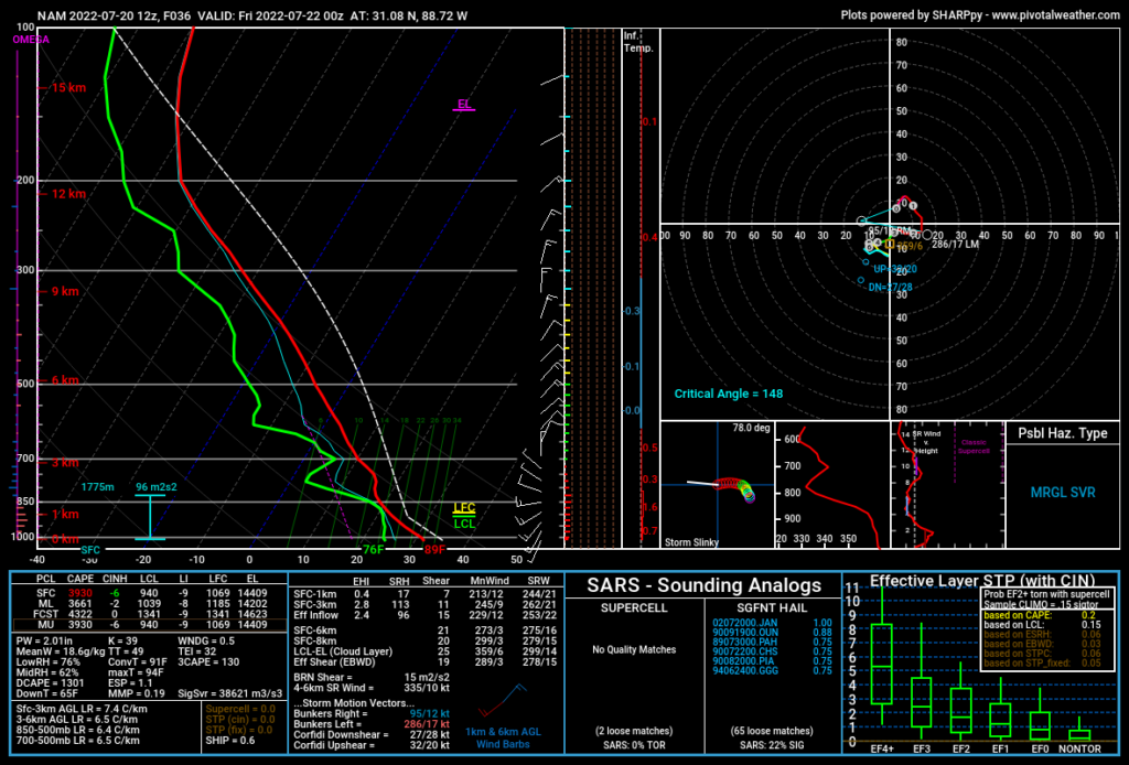
On the sounding shown above, the high CAPE value immediately stands out. Mixed layer CAPE is at over 3500. To put that in perspective, you only need 600 mixed layer cape to have a thunderstorm. Now, high CAPE alone is not enough to produce severe thunderstorms (apart from perhaps a strong pop up pulse storm). The shear is also important. The shear values are not too impressive, only reaching about 20 knots max (40 knots is generally good for severe storms), but when combined with the high CAPE, it does allow for at least a small severe threat.
The general threat is for strong winds, but the Storm Prediction Center also notes a small hail threat, likely due to the high CAPE allowing for strong updrafts. The SCP shows the northern part of the region in a Slight risk and the southern part of the region in the Marginal risk category.
For tomorrow, there may be a small severe threat as well, assuming the NAM model guidance is accurate for this day. As I am writing this, the SPC does not currently have a severe risk listed, however from a sounding as well as looking at the CAPE and shear, I feel at least a marginal risk may be needed if the forecast holds. The CAPE is not as impressive as today, but it is still enough, and shear values are higher than they are forecasted for today.
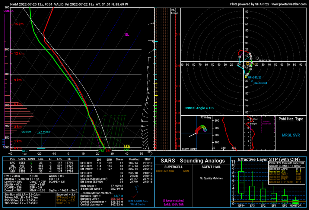
A couple of things stand out to me on this sounding. First, the shear is in the mid 30s (knots). While 40 knots is generally what you would look for to see a significant severe weather day, the current shear forecast may present a small severe threat when combined with the sufficient CAPE. What also stands out to me is the non zero tornado threat in this sounding. If you look in the bottom right corner of the sounding where it says “Effective Layer STP”, you can see the significant tornado parameter. The brown line is above zero. The box and whisker plots show the potential for a tornado of a given strength based on the sounding. Look to where the brown line crosses each individual plot. For example, the brown line crosses the EF0 plot above the first quartile of the plot but below the median. In layman’s terms, this means that the threat for an EF0 tornado is below 50 percent but is not out of the realm of possibility. I want to reiterate that the tornado threat is still low, but I cannot say it is nonexistent. The biggest threat would still be for strong winds.
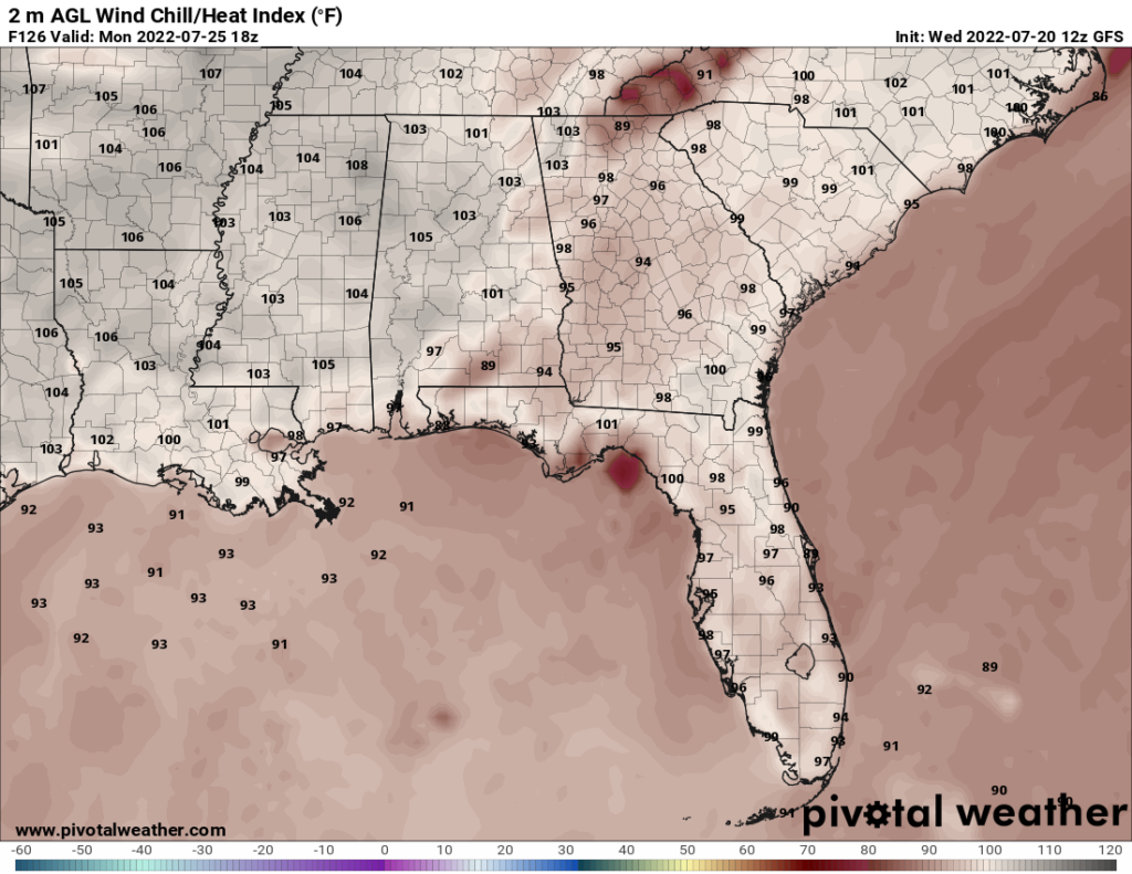
After tomorrow, the forecast becomes more of the same again: high temperatures with the chance for pop up storms most days. The actual high temperatures are not expected to rise above the mid 90s, but the heat index may get to or above 100 on a couple days. For instance, Monday’s heat index may reach 105.
Day to Day Forecast
Thursday
Mostly sunny with a slight chance of thunderstorms. Potential for gusty winds and small hail. Highs in the lower 90s. Heat index between 100 and 105. Winds SW at 10 mph. Chance of rain 30 percent.
Thursday Night
Partly cloudy with a chance of thunderstorms. Lows in the upper 70s. Chance of rain 40 percent.
Friday
Cloudy with thunderstorms. Potential for gusty winds. Highs in the mid 80s. Heat index in the mid 90s. Chance of rain 90 percent.
Friday Night
Partly cloudy. Lows in the lower 70s. Chance of rain 20 percent.
Saturday
Partly cloudy with a slight chance of thunderstorms. Highs around 90. Heat index in the upper 90s. Chance of rain 30 percent.
Saturday Night
Mostly clear. Lows in the mid 70s. Chance of rain 10 percent.
Sunday
Partly cloudy with a slight chance of thunderstorms. Highs in the lower 90s. Heat index around 100. Chance of rain 30 percent.
Sunday Night
Mostly clear. Lows in the lower 70s. Chance of rain 20 percent.
Monday
Mostly sunny with a slight chance of thunderstorms. Highs in the lower 90s. Heat index between 100 and 105. Chance of rain 30 percent.
Monday Night
Partly cloudy with a chance of thunderstorms. Lows in the lower 70s. Chance of rain 40 percent.
Tuesday
Partly cloudy with a chance of thunderstorms. Highs in the lower 90s. Heat index in upper 90s. Chance of rain 40 percent.
Tuesday Night
Mostly clear. Lows in the mid 70s. Chance of rain 20 percent.
Wednesday
Sunny. Highs in the mid 90s. Heat index around 100. Winds S at 5-10 mph. Chance of rain 10 percent.
Wednesday Night
Clear. Lows in the mid 70s. Chance of rain 10 percent.


