This isn’t an understatement for clicks, the NWS in Jackson is also on top of this as we will likely have another excessive heat warning next week. Let’s look into the details about why this is happening and what else will be a little different than earlier this summer.
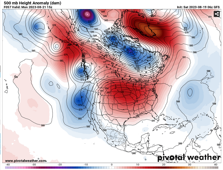
First of all, we’ll look at the upper levels. What you’ll notice is the high anomaly over the northern plains and it spans about 80% of the US right now. What you might not notice is the fact that the center of the ridge is 600mb. That’s incredibly strong. For us, the peak of this will take place towards the middle of the week as the surface high is placed around Arkansas and the upper level ridge is not far behind.
What makes this heat different than earlier this summer?
The main difference from the heat this coming week and what happened a few weeks ago is the placement of the ridge and the dewpoint/humidity. Earlier this summer, we had to contend with either a strong Atlantic Ridge or a Gulf Ridge which has a strong southerly component to the surface and mid-level winds. With the southerly winds, we receive a lot of the Gulf moisture that we’re familiar during the majority of the summer.
With this ridge, however, the placement of it over the Plains and the northern end of the Southeast gives it a more Northerly/Easterly component. With this, there will be less Gulf moisture to deal with which will keep the dewpoints lower during the day. Dewpoints will stay around the 60s while temperatures soar into the 100s and even the 110s in some areas. Heat indices will still reach into the mid to upper 110s with the humidity we already have.
Fire Concerns
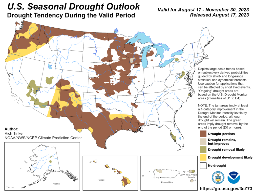
Another major concern we have is wild and brush fires. With such a lack of rain in the past month and the drought extending into West and Southern Mississippi, there is plenty of fuel ready to burn. As I’m sure many counties and cities have already posted, please do not burn anything. Monday is already our biggest concern for wind and that can spread the fire very fast.
The Forecast
Temperatures will remain in the 100s for all of this weekend and into next week. Our main concern for early next week is the wind. A tight gradient with this high pressure zone on Monday will cause the winds to gust up to 20 mph throughout the day.
Looking into Tuesday, Wednesday, and Thursday, this is where the surface high shows up. We will likely reach into the mid-to-upper 100s during the day, especially Wednesday and Thursday. Friday doesn’t look much better as we still will remain in the 100s.
From what Nick mentioned in his blog earlier this morning, the week after next may see temperatures lower slightly as the center of that ridge moves further west, however, we’ll still have temperatures in the 100s until then for the weekend.
[wpcode id=”41179″]
Regional Day-to-Day Forecast
Today – Sunny and hot, with a high near 104. West northwest wind around 5 mph becoming northeast in the afternoon.
Tonight – Mostly clear, with a low around 76. East northeast wind around 5 mph becoming calm.
Sunday – Sunny and hot, with a high near 104. Heat index values as high as 109. Calm wind becoming east around 5 mph in the afternoon.
Sunday Night – Mostly clear, with a low around 77. East southeast wind around 5 mph becoming calm in the evening.
Monday – Sunny and hot, with a high near 100. Light east northeast wind becoming east southeast 5 to 10 mph in the morning. Winds could gust as high as 20 mph.
Monday Night – Mostly clear, with a low around 76. South southeast wind around 5 mph becoming calm in the evening. Winds could gust as high as 20 mph.
Tuesday – Sunny and hot, with a high near 102. Calm wind becoming east northeast around 5 mph in the afternoon.
Tuesday Night – Mostly clear, with a low around 78. South southeast wind around 5 mph becoming calm in the evening.
Wednesday – Sunny and hot, with a high near 106. Calm wind becoming northeast around 5 mph in the afternoon. Winds could gust as high as 20 mph.
Wednesday Night – Mostly clear, with a low around 79.
Thursday – Sunny and hot, with a high near 105.
Thursday Night – Mostly clear, with a low around 79.
Friday – Sunny and hot, with a high near 105.
[wpcode id=”41149″]


