I’ve been getting a lot of questions about when this big ridge and all of this heat finally end. Rightfully. This ridge has been parked over the US for quite some time now. It has bubble up and down and moved around, but has generally had us all ‘by the scruff of our neck’ since June.
I wanted to start with a look back at the NWS site in Hattiesburg.
[wpcode id=”41149″]
QUITE THE SCORCHER
This summer has been quite warm. There is no escaping that. But just how warm?
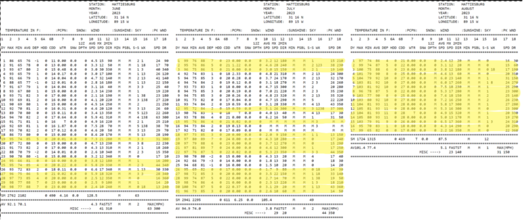
There have been 40 days above 95F since June 1st. Considering there have only been 78 days (of record), that means more than half the days this summer featured a temp above 95F. There have been 13 days greater than 100F. And we have tallied Top 10 consecutive days above 90F and 100F (twice!) this summer.
If we stopped counting today, we would settle the summer with an average temperature of 89.98F. Good for the Hottest summer on record.
And if we look at the forecast for the remainder of the month, And take those into account, you get a final value around 85.4F. That is a full degree hotter than the record set in 2011, which I always considered a nearly unbreakable record as it was almost a full degree hotter than second place.
And if we take the forecast through the rest of the month and compare it to the total number of ‘days above XX value’ we will end the Summer with about 50 days above 95F and about 20 days with temperatures above 100F.
That keeps us around 54-percent of days above 90F and about 21-percent of days above 100F – nearly all of them in August.
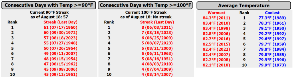
Speaking of August, we are on pace to obliterate the Average Temperature record for August. Currently we are on pace to set the record around 90 degrees. The amazing thing about that is the normal high temperature in August is about 91F. To set the average temperature record one degree shy of the normal high temperature is astonishing, but not surprising given the trends.
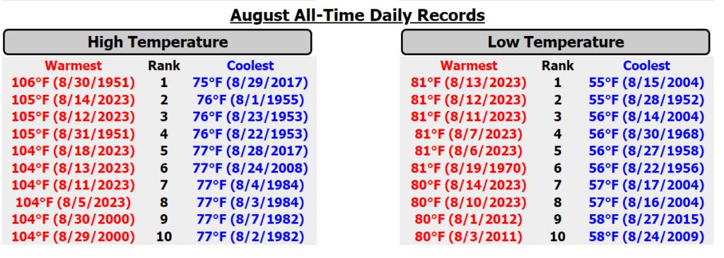
Six of the Top 10 warmest highs in the history of August (back to the early 1900s) are from this year. Same with seven of the Top 10 warmest overnight lows. And we are about to start baking again for the next eight days with forecasts calling for afternoon highs at or above 104F at least four times (including a forecast of 107F on the 23rd) and overnight lows between 81F and 84F at least four times, too.
That means nearly every record warm temperature – high and low – on the lists above may eventually read “2023”
Un. Real. Heat.
And it isn’t just Hattiesburg, the entire area has seen prolonged heat. The NWS sent out a note earlier this week highlighting, “Vicksburg-Tallulah Airport (TVR) set a record high temperature [on] 08/15 of 105F, breaking the record high last set on this date in 2000. Of note, this exceptionally warm stretch also ties 2nd highest all-time daily record for the month of August, last set earlier this week on Mon 08/14. 6 of the top 10 all-time records for the month of August have occurred this year in August, in order of ranking on 08/18, 08/14, 08/12, 08/05, 08/13 & 08/04. Lastly, this ties the 2nd highest all-time daily record overall of 105F, last set on 08/14/2023 & 09/01/2000. 4 of the top 10 all-time records overall have occurred this year in August, on 08/18, 08/14, 08/12 & 08/05.”
So, if you live across southern MS/AL/LA and you’re thinking to yourself, “I don’t remember a Summer this hot!” it isn’t recency bias and you’re not crazy – it has been that hot.
[wpcode id=”41149″]
WHEN DOES IT END?
In about eight days things start to change. But that doesn’t mean an immediate end to the heat. Instead, we will slowly pull away from this intense heat into more manageable warmth. But it will still be hot.
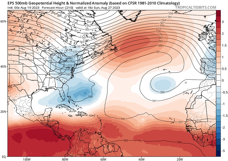
The Euro Ensemble guidance shows the ridge should start to back off to the west by August 27th and troughing digs out just to our east. But operational guidance from the GFS doesn’t cool the area below 95F until about 5 days later around September 1st or 2nd..

Looking at the raw model data from our friends Meteomatics who have developed their own downscaled blend of the European model (which tends to be pretty accurate)we are going to see days around – or well above – 100F through the end of the month. And if you follow the trend here, you can see that it lines up (reasonably) with the GFS guidance above.
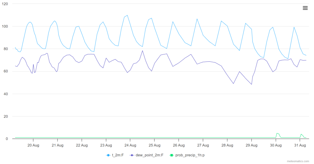
If you want to get really fancy, we can look at the VAR-EPS which looks out through the middle of September. The specific accuracy of this model is still being decided. Currently, I don’t give it ‘super high’ marks, but it does okay “generally” with things.
It shows temperatures really falling off around August 29th with afternoon highs near normal through September 5th and then we warm back to around 100F for about a week, and then cool off again toward the middle of September.

The really interesting thing about this data is the spikes of ‘prob_precip” showing only four or five shots for rain during the next month which I think are a bit too low.
Looking at the mapped version of the analogs of the data above, things don’t look quite as warm. That said, when we are talking about consistently breaking record all of the country, there isn’t really a good analog to pull from.

But I think it does highlight an important bullet point — even when we cool down toward the start of September, we probably have another brief bump of warmth coming again before we can finally wave goodbye to this gigantic ridge.


VERY informative, as usual. Wonder if a REALLY hot Summer will mean a REALLY cold Winter?
Honestly, I’ve just started looking at the Winter outlook and early indications are for a pretty mild Winter. In fact, we may see a very, very mild winter with only a few shots of cold here and there. But it is still pretty early, so I’m going to hold off on any ‘official’ prognostications!
I have been searching for information like this for the last several weeks. Great information and thank you!
Happy to help! Glad you found it useful.
PLEASE correct me if I’m wrong but, with your chart showing the top 10 warmest on record since the early 1900’s, you say that 6 of them are NOT in this year. I’ve counted, and re-counted, and I’m seeing that 6 of the top 10 ARE in this year. Could be wrong … was never good at math. What gets me is that the remaining 4 record highs are toward the end of August and it’s only just past the middle of the month! I guess we’ll see about this Winter.
I’m referring to the chart concerning the month of August only.
You are spot on. That was a typo on my part! Good eyes, Charles!