The southerly wind off the Gulf of Mexico is a big component in the day-to-day weather along the Gulf Coast. But new research dives into just how big a driver that is – particularly in the fall. Turns out, much like summer, the moisture-rich air pushed inland during the fall can lead to more intense rain events.

You may ask, ‘Wait, we needed research for this? That seems pretty straight-forward, Nick.’
Research is done on things like this to try and pin-point exactly what is going on. Sure, it is easy to say that more moisture means more rain, but the authors of the study looked into whether that rain was coming from tropical systems (like hurricanes) or from regular old cold fronts. They also looked into whether the rain was coming more at once or if there were just more fronts move through the area.
Once you clean up all of the data, then you can get down to the nitty-gritty to figure out exactly what is going on.

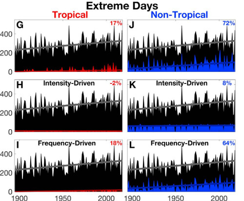
And what is going on is the cold fronts that move through can produce heavier rainfall because there is more available moisture. An quick way to digest the above graphic is to compare the red line on the left to the blue line on the right. The line that is higher up is the one that is more influential.
And in this case, the blue (non-tropical) is higher. For both.
So, for any day with rain, the intensity is increasing (top graphic) and on the days with the most extreme rainfall, the intensity of that most extreme rain isn’t changing… but the frequency of those events is increasing.
In other words, when it rain, it pours… more frequently.
To read the paper by Daniel A. Bishop, A. Park Williams, and Richard Seager, click here.
The Abstract
During 1895‐2018, fall precipitation increased by nearly 40% in the southeastern United States north of the Gulf of Mexico due to increased circulation around the western North Atlantic Subtropical High, which enhanced moisture transports into the region. We find here that these increases in southeastern U.S. fall precipitation manifested almost entirely as increases in precipitation intensity, not frequency.
Further, the enhanced moisture transports increased precipitation totals far more on the highest‐intensity precipitation days than on the lower‐intensity days, leading to nearly all of the increase to be delivered on extreme (top‐5% intensity) precipitation days. Eighty‐seven percent of the fall precipitation increase was driven by non‐tropical storms (mostly frontal), not tropical cyclones, though the proportion of precipitation falling as either storm type did not change. Further research is needed to evaluate whether these observed precipitation increases are likely to continue, stabilize, or reverse.
The data
It is well-documented that extreme rain events, in the Southeast during the fall, are often caused by Tropcial Systems. The climatological peak of the Atlantic hurricane season is September 10th, and the region can see tropical systems move through all the way through Halloween. In fact, during the last five years, there have been six tropical systems that have affected the Gulf Coast. One of which, Hurricane Harvey, smashed all kins of rainfall intensity records.
But this study was looking at non-tropical related rainfall. From the Authors:
Here, we investigate the influences of daily precipitation intensity, frequency, and storm type on the observed increases in fall precipitation in the southeastern United States during 1895–2018. Our analysis seeks to answer the following questions:
1. How did extreme precipitation affect the observed fall precipitation trend in the southeastern United States?
2. Did the observed fall precipitation trend in the southeastern United States align with a specific storm type such as tropical cyclones?
But first we have to figure out where the authors are looking.
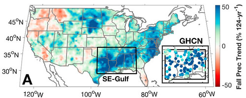
The authors made a geographic box immediately north of the Gulf of Mexico (29 to 37°N, 98 to 84°W) that runs from aboutFreepot, Texas through about St. Marks, FL. The area, according to the authors, has the largest fall wetting trend in the contiguous United States. The authors grabbed the daily precipitation totals for 1895‐2018 from the U.S. subset of the daily Global Historical Climatology Network. They made sure weather stations were only included if, for at least 75% of 1895–2018 years, all three fall months (September–November) had valid observations of precipitation total on at least 95% of days.
The authors also grabbed some of the 700mb moisture flux data, too, however for this review, that is less important.
Conclusions from the Authors
Here are two snippets of the conclusions from the authors:
Substantial increases in southeastern U.S. fall precipitation during 1895–2018 were driven mostly by increased precipitation intensity, with little change in the number of precipitating days. The increase in precipitation intensity occurred as an intensification of the strongest storms leading to more precipitation events exceeding the extreme (top 5%) threshold. Despite fall being tropical cyclone season, the intensified precipitation events that led to the increase in fall precipitation total were mostly frontal storms. Tropical cyclone intensity also increased slightly, however. Our previous research indicates that the observed increases in non‐tropical precipitation intensity that we report here have been driven mainly by enhanced mean atmospheric circulation around the western ridge of the North Atlantic Subtropical High, which led to increased moisture transports into the southeastern United States from the Gulf of Mexico (Bishopet al., 2019). Our findings here provide further insight into how increased southerly moisture transports from the Gulf of Mexico have manifested as increases in southeastern U.S. fall precipitation
The most severe flood events in the southeastern United States are often associated with tropical cyclones, such as Hurricane Harvey in 2017 (Emanuel, 2017; van Oldenborgh et al., 2017).However, non‐tropical (mostly frontal) systems compose the vast majority of the southeastern U.S. fall precipitation in terms of both total precipitation and number of storms. It is therefore reasonable to suspect that continued intensification of non‐tropical storms would enhance the risk of severe flooding as extreme precipitation totals become more commonplace among already frequently observed frontal storm types.While the thermodynamic (humidity‐driven) contribution to the southeastern U.S. fall precipitation trend has been small relative to the dynamic (wind‐driven) contribution (Bishop et al., 2019), the projected warming‐induced increase in atmospheric moisture content is expected to amplify extreme precipitation increases globally (Allan & Soden, 2008). In the southeastern United States, models do project daily precipitation extremes to intensify due to anthropogenic warming (Pendergrass et al., 2017), but the observed,circulation‐driven increases in fall precipitation in this region far exceed simulated trends (Bishop et al.,2019). Should the as‐yet undiagnosed circulation‐driven increases in extreme precipitation continue, and if these co‐occur with model‐projected increases in extreme precipitation that is driven by increases in humidity, it follows that the resultant increases in storm intensity could increase flood risk beyond that which may be inferred from current climate‐model projections of precipitation.
Interesting to note that the increase in intense / extreme rainfall events was tied to fronts more than tropical systems.
What those conclusions mean for you
Flooding is becoming more of a risk along the Gulf Coast during the Fall. Anecdotally, during the last five years, it seems that flooding events have become more common in the fall. Now, there is research to back it up.
I think the authors have done a pretty good job here of spelling out the difference between intense tropical and intense non-tropical rain events. And it really highlights how our changing climate continues to modify how we need to prepare for weather.
Generally along the Gulf Coast the thought is that during the Fall, unless there is a hurricane, there isn’t much weather of consequence. And that may still hold true ‘most of the time’ but it isn’t true ‘all of the time’ anymore. As cold fronts swing through, or subtropical storms develop, or tropical waves meander across the region, there is a chance for substantial rain to fall and flooding to occur. And that risk is higher today than it was 50- or 100-years ago.
I hear from people all the time that say “You know, it didn’t used to rain like this when I was a kid…”
Research like this shows that those people aren’t wrong.
In fact, other research – completely independent of this research – has found a similar trend. For South Mississippi, there has been an increase in heavy rainfall events, in general.

This new research about fall precipitation is another piece of data to support the finding of the previous research about heavy rainfall, in general.


