Good evening everyone and thank you for joining me again for another look my review of a scientific article! Tonight I’m taking a look at Interaction Between Subtropical and Polar-Front Jet Stream by E.R. Reiter (very close to my name!) and L.F. Whitney. The jet stream topic in my severe storm forecasting class was something that truly boggled my mind when I was first introduced to the topic, but as I tried to get outside perspective and look at various scientist’s explanation of how air moves within the jet stream, I finally understood it and what I found was astounding! Therefore, I was really excited to get to read this article and gain even more information into the variance in the jet stream. Take a look at what I found. . .
Summary:
The article begins by looking at a study by Oliver, Anderson and Ferguson from 1964 (relatively new considering when this article was originally written) and their look at cloud development between the two sides of these jet streams. The conclusion from this comparative study was that in an optimal atmosphere with perfect conditions, high-level cirrus clouds would create enough of a band to be seen on TIROS photographs. From there, Reiter and Whitney claim their purpose for writing this article is to, “expand on this concept by providing additional documentation,” (433). Their main focus begins with a look at the jet stream on November 20, 1962. They recount seeing cloud heights being clearly visible in the image shown below.
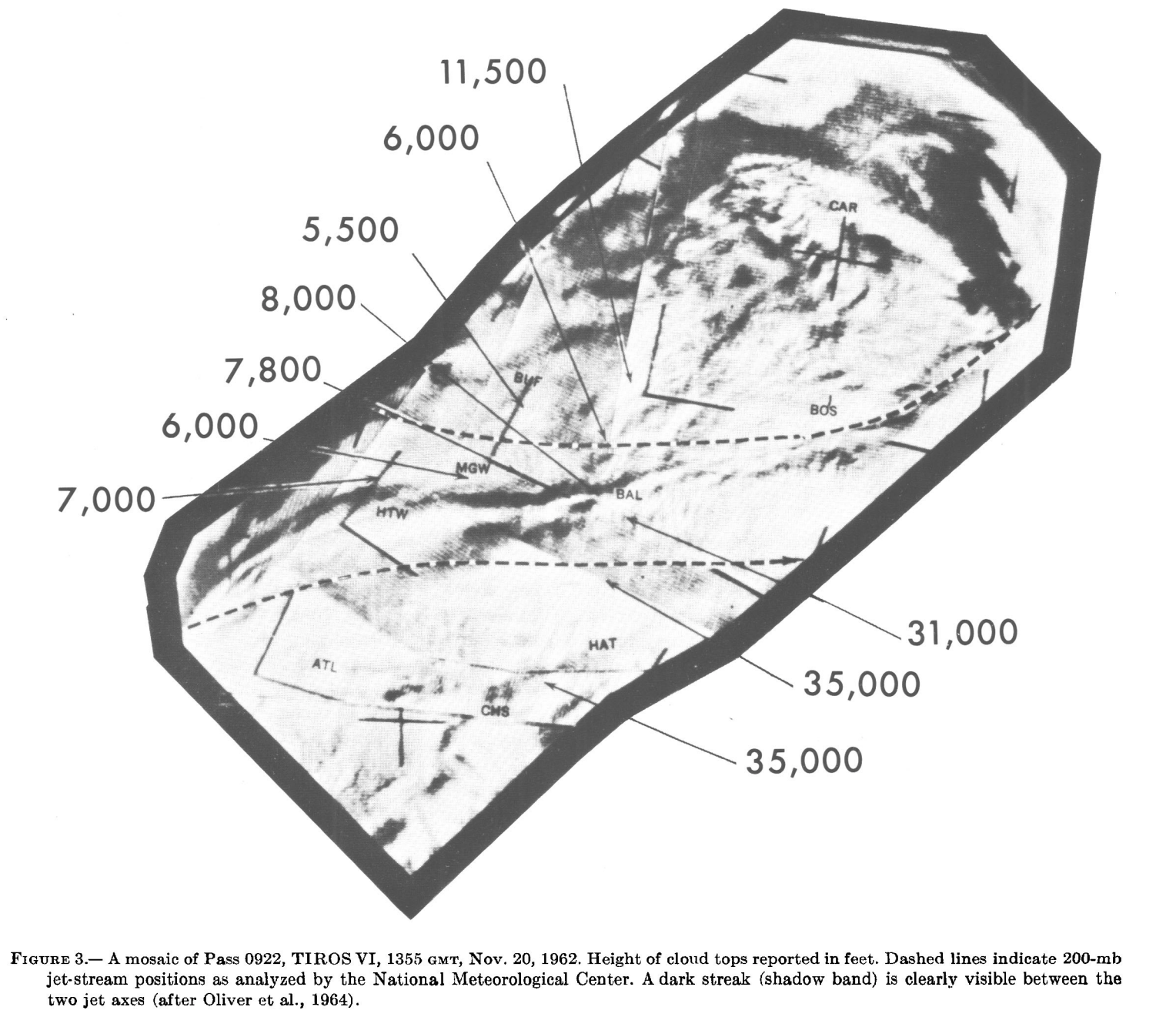
There is a sudden change in cloud height which was also verified by pilot reports and they describe how at 1448 (2:48 p.m.) the shadowed line was virtually stationary. At 1200 on this day, a jet out of the northwest merged with a southwesterly flow that alone was strong over Pittsburgh and Huntington. Only one jet was seen in figure 4 (provided below), and they recognize that Oliver saw how the seemingly parallel jets were the cause of the dashed lines heading through the northeast. Thus, identifying the overlapping of streams into one line but splitting into different isotachs. Additionally, they note how precipitation was found in the right rear quadrant of the strong stream and joins the vorticity distribution to create upper divergence pattern.
Furthermore, Reiter and Whitney show that a frontal zone becomes prominent under the southern region of the stream, which goes forth to negate the jet stream as an STJ (subtropical jet) due to the baroclinicity of the upper troposphere being above 400mb or 500mb. The authors introduce a term, “motorboating” which refers to, “a layer of dry air with its base at 10,000 to 15,000 ft,” (435) which outlines the vertical quantity of cloud coverage in the area.
In figure 3, we see the “cirrus shield” as it ends suddenly on the anticyclonic side of the jet and, ” diffuse baroclinic zone which contains motorboating humidity reports,” (436). This indicates stratosperic levels in the “tropopause gap” which has also been seen in transportation of debris from the stratosphere to troposphere. They state, “it appears that at least in this case the subsistence of stratospheric air within the baroclinic frontal zone beneath a jet stream is most effective in regions where two well-developed jet branches are merging,” (436).
In the conclusion of the article, Reiter and Whitney claim that by basing the bands in TIROS cloud photographs could be an effective way to study the deficiencies within the normal jet-stream idea. They make 4 main points:
- Two established jet branches might not meet the criteria to be classified as a PFJ or STJ
- Implications from crossover flow might be imperative for stratospheric and tropospheric exchange
- If jet axis cross to make the southern jet cross the northern jet, the cloudiness would remain on the anticyclonic side of the flow
- Observation of shadow bands is dependent on satellite imaging in relation to variables such as the sun angle and spatial positioning
3 Things for Future Study:
- The assumption that cirrus clouds, “broke off slightly to the north of Shreveport, to remain on the anticyclonic side of the southern branch as postulated by Kadlec model” – how can we assume that this was the response of the clouds? Who’s to say that the clouds didn’t turn south?
- Why are the vorticity more difficult to predict even considering the high wind speeds near the jet core and the absolute vorticity reaching zero? – At this time I can see how their technology would have prevented a lot of in depth research so is this still a problem? Does vorticity measurements become harder to collect with higher wind speeds?
- “Clear-air turbulence” – the authors state that Reiter and Nania found that clear air turbulence is found where jets cross one another which creates a large vertical wind-shear vector. – Why is this the case? what about the crossing of jet streams creates this cleared air?
Modern Meteorology:
This dated article gives light to the modern look at the beauty within technology that we use today to take a closer look at jet streams. We’re now able to break them apart and examine them in greater depth. Modern meteorology has come so far into the ability to understand why the air around jet streams reacts when they cross and what initially leads streams to cross.
Thanks for reading ya’ll, goodnight!


