Take a look at this article I found, it’s a look at some rare cloud formations in Oklahoma and I think it’s a pretty cool read in understanding potential causes of these clouds.
Summary:
This article looks at a development of reticular clouds from June 4th, 1995 in Norman, Oklahoma. Pictured below is the formation that seems to be fixed with a thunderstorm outflow from the anvil base. The original photographer took numerous pictures over the course of 45 minutes and included in these was the picture found below:

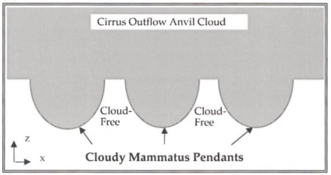
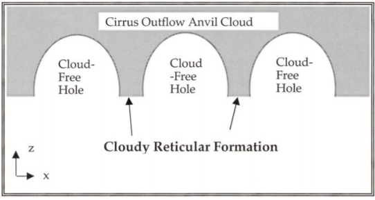
The initial response to classifying this cloud formation was to label it a mammatus cloud which is bubble like pockets that protrude from the bottom of a cloud base, however after further examination, the authors discovered that the lighter spaces (referred to as “holes” by the authors), are actually not clouds at all and are instead, the absence of clouds. The darker lines forming a woven pattern or “netlike pattern” as described by the authors are the presence of clouds in very thin bands to form the rings around the gaps.
The difference between the reticular clouds and the mammatus are described by the authors as follows:
Mammatus Clouds – “‘hanging protuberances, like pouches, on the under surface of a cloud'” (Huschke 1959) The diagram below illustrates the shape looking at the cloud through a vertical slice of the cloud layer. The picture followed shows a real picture of said clouds.
Reticular Clouds are found to have the opposite formation and thus are essentially an inversion of a mammatus cloud. (As seen in the diagram below)
As the authors look to begin identifying possible causes of this type of cloud formation, they first introduce a statement from Ludlam and Scorer (1953) stating, “though reticular (netlike) clouds do appear, it cannot be concluded from their appearance that downward motion in the middle is producing the evaporation of the clouds, for the holes may be due to the perforation of the cloud layer by a clear layer below.” Upon further examination, the authors provide the meteorological conditions for the area on this day. We’re informed of several thunderstorms surrounding the area of where the cloud formation was found, we see heavy rainfall in Norman and in the southwest neighbors. A thunderstorm established in Fort Cobb, Oklahoma (west-southwest of Norman) is believed to be the host of this anvil downdraft created cloud bank. Significant winds were found and created notable directional shear.
To explain this unique formation, several explanations are provided in the author’s discussion section:
- Presented by Scorer (1972) suggests the, “fallout of ice crystals due to subsidence of a newly glaciated cirrus cloud deck. Crystals that fall from the cirrus deck into the dry layer of air below could induce local downdrafts, which may cool and moisten the ambient air through which they fall by sublimation.” (420)
- The authors conclude that the problem with Scorer’s proposal is that this occurred during a thunderstorm which would negate the ice crystal aspect and rather suggest they would be water droplets.
- The authors state that, “the nearly saturated layers at, and above 562mb, are assumed to represent the thunderstorm outflow anvil cloud deck. ” (420)
- The authors then state that the wind speeds and directional shear would contradict this hypothesis.
- As an alternative, the authors suggest that the formation could have been a result of the dry-adiabatic layer from 608 to 562mb has the potential to steepen the lapse rate of the area. They go further and explain that, “in this case, weak downdrafts could bring dry air downward and create clear holes in the moist layer at 623mb.” (421)
- They include how Scorer expound upon this idea in that the lifting of dry air could act like a perforation source and essentially cut through the thin cirrus cloud bank which would result in the “holes”.
The authors conclude their article by stating how while they don’t have a definitive answer to the cause of these clouds, they do note how incredibly rare reticular clouds are and how most of the solutions at hand are purely speculation.
3 Things for Further Study:
- The authors themselves included their comments for further study, claiming that more numerical study would be helpful in the study of thunderstorm anvil outflow.
- The differences between mammatus and reticular cloud formations – what leads to the inverted processes of these two formations?
- Thunderstorm outflow development and results – what other effects do we see with the downdraft of an anvil cloud?
Modern Meteorology:
The authors set a “call to action” for the audience to increase investigation of this cloud development and give more attention to the small details that would overlap for unique cloud development. This article looks at how scientific research doesn’t have to solely be about the next best forecasting or prediction methods, but could reach to include the small and unknown oddities in the weather world. Just a small reminder of the nuances of weather that still give it a little bit of wonder and joy into discovering something that we have very little understanding of.
Thanks for reading! I’ll be bringing two more reviews this week to catch up on the one I missed last week so stay tuned!


