Good evening lads and ladies! I’m here to bring you yet another article review! If you haven’t caught on to it, I post these twice a week and I provide a summary, 3 points I would like to see further study on, and what this means for modern meteorology.
This is another long one but oddly enough, I really enjoyed the approach of this article. It seems like nowadays, everyone wants to be the one who finds a more finite way of predicting tropical cyclones and ensuring the most accurate information is used for future research. Anyway, take a look at what I found in Uncertainty of Tropical Cyclone Best-Track Information by Ryan Torn and Chris Snyder.
Summary:
To begin, the audience is already facing the challenge as posed by the authors, “few studies have taken into account or tried to objectively estimate the inherent uncertainties in TC position and intensity, measured by minimum sea level pressure or maximum wind speed, contained in these datasets,” (715).
From there, the audience sees how both Torn and Snyder seek to propose a study in which more valuable elements are included in study and adequately give a well-rounded approach. Through various looks at probability (past and present methods) in connection to the data readings from numerous sources; they discover that confidence and certainty (as found in the title) are achieved when more advanced sources are consulted for data analysis.
They claim that, “by verifying satellite-based intensity estimates against best-track data during times with reconnaissance data over a 10-yr period. The latter is used to define intensity uncertainty because a majority of TC intensity estimates are obtained from satellite-based algorithms and NHC does not provide estimates of intensity uncertainty,” (726).
The proposal is then made that because there are so many algorithms that all use this data, they should be entered into one ensemble and have studies run the culminated ensemble rather than rely on one alone. They clearly state that they find the microwave-based values to be, “objective, automated, and based on a completely different algorithm,” (727).
I find this study was one of the first that was successful, not because their study concluded any new evidence, but they actually created a new plausible solution to the enacted methods of today. Whereas other studies merely said what to do next time, this study found useful answers that could be implemented if so chosen by the NHC.
3 Things for Further Study:
- How does the microwave data from satellites provide a more precise look at TC intensity? Why does this give us a better look as opposed to having data sent back from aviation that gathers it straight from the center of the TC? I would like to see how they discovered that this was worth adding into algorithms and how they factor this in with all of the other data.
- Dvorak technique – I would personally like to study this more. They elude to a summary of what it is, but leaves more questions as to how this was discovered and why it’s still seen as the most widely accepted practice.
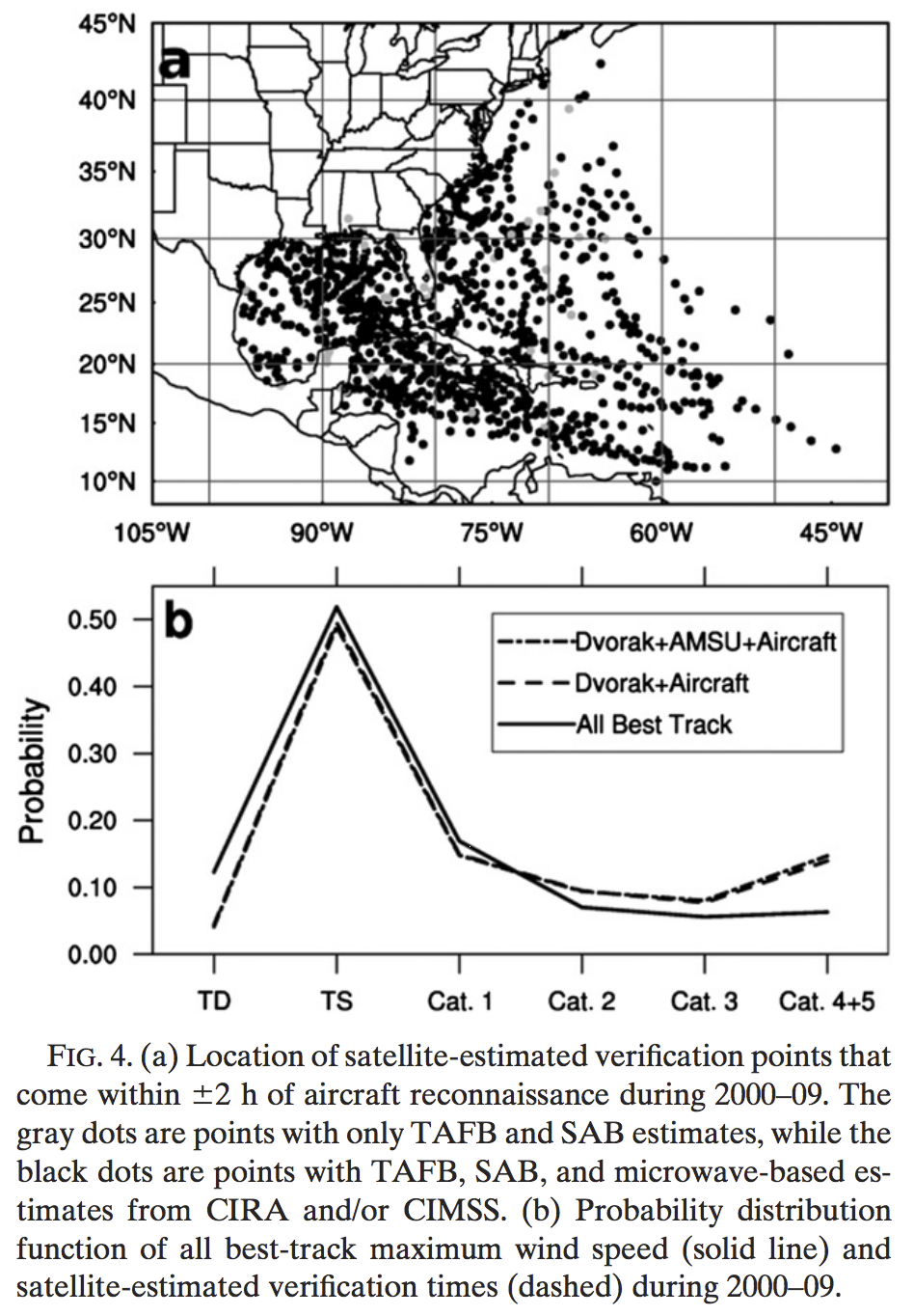
- The aircraft fixing aspect in figure 4a. shows that the Dvorak+AMSU+Aircraft follows almost exactly the same probability of category track as the Dvorak+Aircraft only. How then does the aircraft fix the probability and how is this calculated with the other variables. – I think overall, I would like to see what this actually does and how it’s conducted in a study.
Modern Meteorology:
This study challenges that as of now, the algorithms use incomplete or data that could be more thorough when looking at storm probability. They present a good case in where they add numerous elements to the preexisting methods and adapt the practice to show a better outcome. I think that if this type of study were to continue, not only would looking at previous storms give more conclusive predictability for the next time one occurs, but also give real-time forecasting a much more advanced and perhaps accurate study. All of this, to ultimately create less damage and gain a quicker response in due time to provide ample warning without causing chaos with uncertainty in a forecast.
Thanks for reading! You can find the original paper here: https://journals.ametsoc.org/doi/pdf/10.1175/WAF-D-11-00085.1


