There is another threat for severe weather coming up this next week, but so far deterministic model guidance has been slow to develop any specific outcomes that feature a potent severe weather setup while the ensemble guidance shows a higher risk.
I wanted to explore the reason why there may be a difference. And I think I may have stumbled upon the reason.
Past research
A few years ago (almost four!) I had the chance to chat with Matt Haworth, a meteorologist at StormGeo. At the time, he was working on research following up on a previous study about how Gulf of Mexico sea surface temperatures impacted the potential for severe weather that was done in the 90s.
Here is a look at our brief chat:
“Basically I expanded on a study done by Roger Edwards and Steven Weiss out of the Storm Prediction Center done in 1996,” Haworth said. “I expanded the study to include the areas within 100 miles of the Gulf Coast.”
Haworth found that there was an increase in severe weather when the Gulf of Mexico sea surface temperature was higher.
“During the warm cases, we had over 110 out of the 202 cases (of severe weather) I found,” Haworth said.
The idea is that an small increase in sea surface temperature could mean extra moisture available in the atmosphere. And, as echoed by Holworth’s colleagues in other presentations, an increase in dewpoint means more CAPE (instability) – regardless of the amount of instability available from daytime heating.
You can find the original post with Matt Haworth’s interview here!
The next year, at the American Meteorological Society’s annual meeting he presented his research. Noting the difference between Warmer, Cooler and Neutral Gulf of Mexico temperatures.
Here is his presentation from that meeting:
Just as an aside
In his presentation above he references a March 28th event. I recall forecasting that event. The SPC put out a Slight Risk for the day.
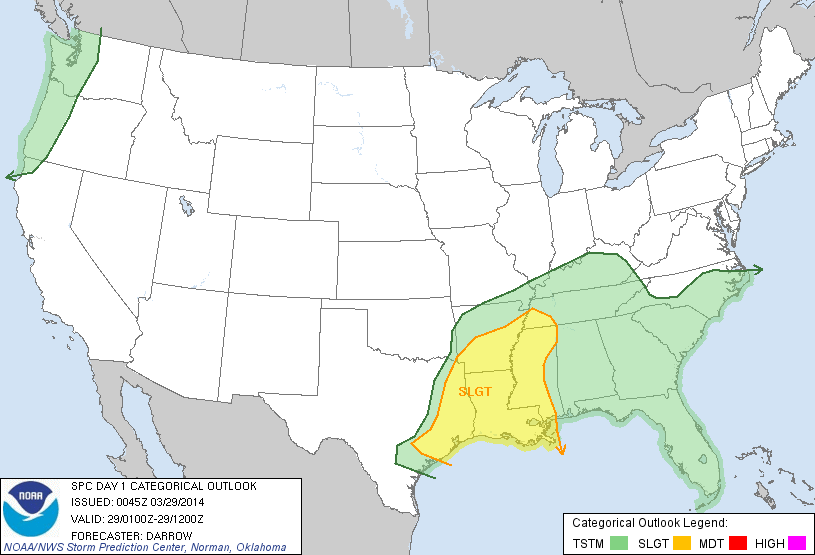
That morning, I put out this forecast…

And the final storm reports looked like this….
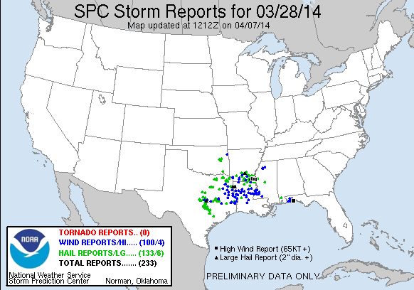
It was both a good and bad forecast, personally. I think I over-warned folks in Mississippi, alabama and Tennessee. But definitely gave a better forecast than the SPC for Texas, Louisiana and Arkansas.
Always interesting to revisit old event when I watch presentations like that. Sometimes it is a good forecast, other times not as good. I would vote this one… decent.
What does this mean for next week (the science-y explanation)?
Great question. Given the presentation above, I wanted to take a look at the Gulf of Mexico sea surface temperatures. To my knowledge, the ensemble guidance doesn’t take variable SSTs into account as much (if at all) as the deterministic guidance.
So what do the temperatures look like? Like this:

Notice that the ‘loop current’ is still out there. But aside from that, the Gulf is generally “cool” and running between 17C and 23C. But how does that relate to average?

It looks to be a mixture of running above average in some spots and below average in others. With the ‘loop current’ as the sticking-out-like-a-sore-thumb above average area.
That makes sense. Since that is just the surface waters, and recently with a northwest wind, cooler water has been allowed to upwell closer to the coastline. Plus runoff from rivers to the north have been dumping cooler water into the Gulf.
But as high pressure builds in, that may allow for warmer water to get shoved back north. And perhaps even allow the warmer waters at depth further out to sea to mix toward shore as well.
The question is, does that even exist? For that we ahve to use sea height anamoly to get an estimation.

The short answer is “sort of” and the longer answer is “it depends” and the reality is that generally it looks like ‘cooler’ waters may be the predominant profile closer to the coast, but further out to sea, warmer waters exist – so the fetch of wind in the coming days may provide the ultimate answer. And on top of that, how those winds interact with the water’s surface and how it transports the any warmer water closer to shore will also play a role.
What does that mean for next week (the non-science-y explanation)
Given the past research showing that (1) cooler sea surface temperatures lead to a greater threat for hail, and a lower threat for tornadoes as well as (2) the potential to shift the placement of the marine layer and thus the overall threat for severe weather… And the current predominant water temperature profile closer to the shore is ‘cooler than average’ at the moment, there is some question about whether a true tornado threat will develop. And there is also some indications/evidence that it may shift the severe threat further inland, too.
For now, it is worth watching.
The CIPS Analogs – using ensemble guidance – continues to show a threat for severe weather
Today’s CIPS for Day 6 / Day 7 pic.twitter.com/fbJimfn2D9
— Nick Lilja (@NickLilja) January 19, 2021
While the operational /deterministic guidance continues to show very little fanfare as the front rolls through next week.

The Bottom Line
There is a chance for showers and storms across the Gulf Coast Thursday and Friday of this week, but it looks like the threat for severe weather is minimal. Next week on Monday and Tuesday, it is worth watching, but for now there is still enough uncertainty between model guidance to “put a flag in the sand” and claim one way or another.
Please just keep tabs on the forecast through the weekend.


