Pretty benign weather this week. There will be a few shots for storms, but it looks like while severe weather is possible this weekend, it doesn’t look likely by any means. Just riding the weather roller coaster of temperatures going from mild to cool. Beats tornadoes, that’s for sure!
We will have another cold morning on Friday with most folks waking up around 30 degrees. so cover up those plants that don’t like the cold.
For those concerned about the chance for storms, the threat for any kind of severe weather will wait until Sunday as the second cold front moves through the area. As it does so, it will allow some Gulf moisture to ooze north. And that will allow some moderate instability and weak shear to overlap.

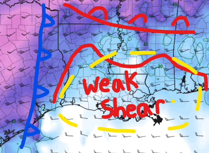
This will be another conditional, low-end event fo the Gulf Coast where the threat is low and the potential for significant severe weather is also low. But we can’t rule out the chance for some wind gusts up to 60mph or a brief weak tornado.
But I really want to stress here that the potential for those things to occur is very low.
And, in fact, there isn’t much on the horizon (within the available data) that screams “severe weather” through January 20th. So that is good, too!
Day to Day Forecast
Today
Partly cloudy with a 10-percent chance of showers in the afternoon. Highs in the mid 60s.
Tonight
Partly cloudy with a 10-percent chance for showers overnight. Lows in the lower 50s.
Thursday
Partly cloudy with a few showers and storms possible. Severe weather is unlikely. Highs in the mid 60s. The chance for rain is around 40-percent.
Thursday Night
Partly cloudy. Much colder. Lows around 30.
Friday
Sunny, cooler. Highs in the lower 50s.
Friday Night
Mostly clear. Lows in the mid 30s.
Saturday
Mostly cloudy with occasional showers and storms. Warmer. Highs in the upper 60s. The chance for rain is around 30-percent.
Saturday Night
Cloudy with passing showers. Much warmer. Lows in the upper 50s. The chance of rain 60-percent.
Sunday
Cloudy with storms likely. Severe weather possible, but not likely. Highs in the lower 70s. The chance of rain 70-percent.
Sunday Night
Mostly cloudy with a 40-percent chance for lingering showers. Cooler once skies clear. Lows in the mid 40s.
Monday
Partly cloudy in the morning, then clearing. Cooler. Highs in the mid 50s.
Monday Night
Mostly clear. Colder. Lows in the mid 30s.
Tuesday
Sunny. Highs in the lower 50s.


