Author: Nick Lilja
|| Published: 2/10/2020 at 9:42am
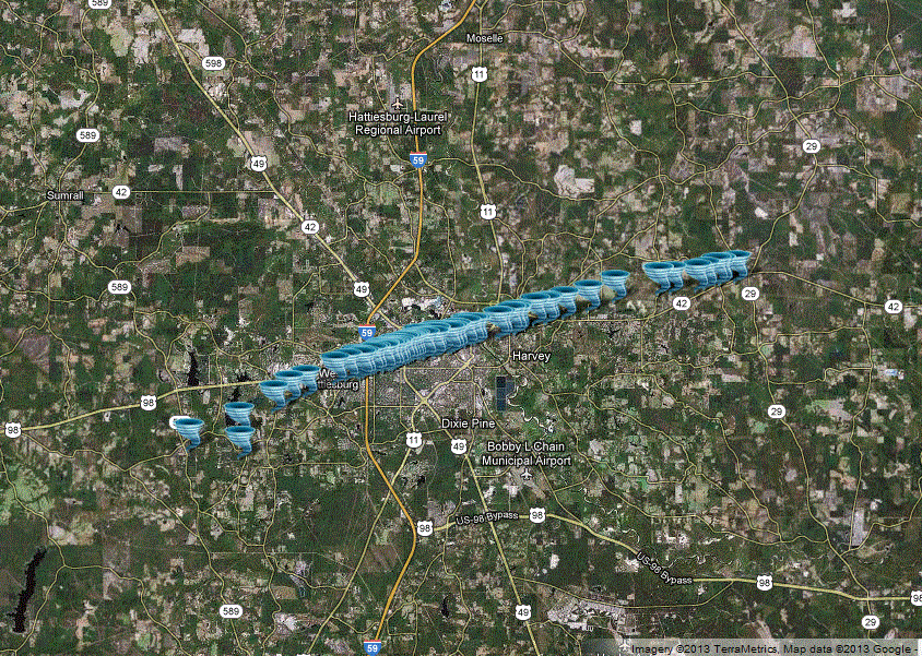
Tornado track // Courtesy: NWS Jackson
Seven years ago today, at 5:03pm the supercell moving through Lamar County spawned a tornado that quickly gained intensity and move through Hattiesburg and Petal. The eventual EF-4 tornado was only on the ground for 33 minutes. It traveled 21 miles.
Despite the dozens of injuries, no one was killed.
Official account of the tornado
From the National Weather Service in Jackson, Mississippi:
The tornado started along Highway 589, where some limbs and small trees were downed. It became intense rather quickly, producing significant damage as it moved through the West Lake Serene area. The tornado reached its maximum intensity in the area around and just southwest of Oak Grove High School. There was a brick home in a subdivision southwest of the high school, just west of old Highway 11, that was completely leveled with all interior and exterior walls down, and a fair amount of large debris was blown downstream. Additionally, very high end timber damage occurred in this location with a number of trees showing debarking and denuding. Several other homes in this subdivision also sustained EF-2 to EF-3 damage. As the tornado crossed old Highway 11, it produced extensive damage on the campus of Oak Grove High School. The field house adjoining the football stadium was destroyed, the baseball stadium and a large metal building adjoining the stadium were essentially destroyed, and several large steel/concrete light standards were snapped at both the baseball and football stadiums. A vehicle was thrown from the parking lot adjoining the baseball stadium, up a small hill and was deposited near the pitching mound in the middle of the baseball field. The main building of the high school also suffered some roof damage.
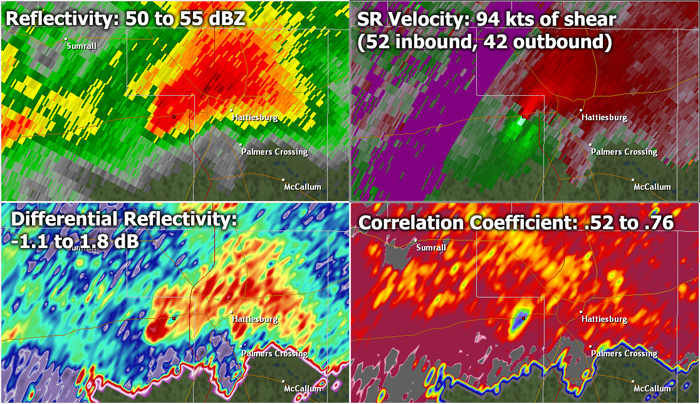
Radar imagery of the tornado // Courtesy: NWS Jackson
The tornado then moved northeast into the heavily populated areas of Oak Grove and West Hattiesburg, including areas along Lincoln Road Extension, Weathersby Road, Oak Grove Road, and the area just south of Highway 98 along Clark, Lamar and Foxgate Avenues. Numerous homes were destroyed or suffered major damage, and a few homes showed evidence of high end EF-3 type damage. Dozens of power poles were snapped, extensive tree damage occurred. Video evidence and ground survey damage appeared to indicate that the tornado was multi-vortex in nature during its Lamar County portion. Just before crossing Interstate 59, it caused significant roof damage to a number of apartment buildings just west of the interstate. In total in Lamar county, preliminary estimates from emergency management indicate that 51 homes were destroyed and 170 suffered major damage. There were 8 reported injuries, 2 of which were critical.
The tornado moved into Forrest County just to the south of Hardy Street damaging numerous homes with the damage in the EF-2 and EF-3 category. It then crossed Hardy Street impacting the southeast corner of the University of Southern Mississippi campus. Numerous buildings were damaged in this area including several campus buildings and a large church. Numerous power poles were downed in this area and several medal traffic lights were bent and torn off their bases. Damage in this area was also EF-2 and EF-3.
The tornado continued across Highway 49 impacting multiple neighborhoods. Numerous roofs were blown off houses and many trees fell on houses and vehicles. The tornado crossed north Main Street causing significant damage to the Red Cross building and the Girl Scouts building and bending large metal poles at the Hattiesburg High School athletic fields. The tornado then moved across east 7th Street causing significant damage to several large brick buildings. Damage in the area between north Main Street and east 7th avenue was in the high end EF-3 range with maximum winds around 160 mph.
The tornado continued into Petal with the most significant damage occurring to a Tru-Value hardware store on south Main Street. Numerous homes in the vicinity of the hardware store also had roofs torn off and exterior walls collapsed. This damage was also rated high end EF-3 with maximum winds around 160 mph.
The tornado began to weaken as it crossed the Evelyn Gandy Parkway to the northeast of Petal. Damage in this area was mainly EF-1 and EF-2 and consisted of roof damage and snapped trees. The tornado strengthened one last time as it moved through a neighborhood just off Twin Lakes Road. Numerous well built homes experienced EF-2 damage to the roofs in this neighborhood. The tornado weakened as it approached the Perry County line and dissipated a couple of miles into Perry County. Damage at the end of the track was in the EF-0 to EF-1 range.
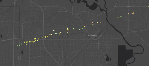
a portion of the Hattiesburg / Petal EF-4 track // Courtesy: apps.dat.noaa.gov
In total in Forrest County, preliminary estimates from emergency management indicate that 133 homes were destroyed and 207 suffered major damage. There were 63 reported injuries.
This is the second violent tornado to impact Lamar and Forrest counties in our records. The other violent tornado was the infamous Purvis tornado on April 24 1908. This tornado was on the ground for 155 miles and impacted many parishes/counties across Louisiana and Mississippi. In total 143 people were killed by this tornado, including 60 in Lamar County and 4 in Forrest County.
Another violent tornado would move through the area again in January of 2017. And in 2019, it would be the first time since 2009 that a tornado didn’t move through the Hattiesburg city limits during an odd-year (2011, 2013, 2015, 2017 all feature a tornado).
Of note, while a lot of people refer to this tornado as the “Hattiesburg EF-4” it was actually only an EF-3 tornado in Hattiesburg. The EF-4 damage happened in Petal.
On the ground
Ryan Moore, who was working at the Hattiesburg American at the time, was in the path of the storm and managed to get some of the very first pictures of the destruction
The Weather Channel featured this storm on their Tornado Alley show.
Part1:
Part 2:
Author of the article:
Nick Lilja
Nick is former television meteorologist with stints in Amarillo and Hattiesburg. During his time in Hattiesburg, he was also an adjunct professor at the University of Southern Mississippi. He is a graduate of both Oregon State and Syracuse University that now calls Houston home. Now that he is retired from TV, he runs this site and its app in his spare time.