Looking at the latest model trends, there is still the potential for severe weather Saturday night and into early Sunday morning for South Mississippi.
As a deepening area of low pressure moves from East Texas through Arkansas and into Tennessee, a warm front will lift north through the Gulf Coast region during the day on Saturday. Along the front, some showers and thunderstorms may develop across parts of Texas, Arkansas, and northern Mississippi. But the main event will be the development of storms along the cold front Saturday afternoon, evening and into the overnight hours.
That front could spawn a handful of discrete supercells and then eventually a broken line of showers and storms that pushes through southern sections of Louisiana, Mississippi and Alabama.
What we know
The line of storms that moves through could be pretty potent, even if they aren’t technically severe. Most thunderstorms on Saturday night and into Sunday morning will feature heavy rain, frequent lightning, wind gusts greater than 30mph.
That is likely with every thunderstorm. At a minimum.

That said, this sounding data would suggest that the atmosphere is capable of producing and sustaining significant severe weather. More on that in a second.
The timeline is also looking reasonably stable – between 9pm and 6am for South Mississippi. But that may wobble a bit, too. Details on that below
What we don’t know
We don’t know if the cold front will produce and sustain significant severe weather… yet. We are just starting to get within the range of our modeling that allow us to get a better idea about where the stronger storms may be.
And where the strongest storms develop is going to be decided by how fast the cold front moves, as well as, how much rain the area receives on Friday.
One early estimate is for a line of storms to develop in Louisiana and fall apart as it approaches South Mississippi. At the same time another line of storms, ahead of that first line and already in South Mississippi, may develop and move east through the area and into Alabama.
This isn’t a “likely” scenario, but it is the first attempt by one of the shorter-range models to figure out what will happen. So, what we are trying to figure out is just how likely that outcome is, when the first line dies, when the second line forms, and if there is any severe weather involved with either in South Mississippi. Or does the first line just hold together the whole time.
Generally, forecasts on specifics like “specifically where storms will develop” and “how strong the storms will be” can’t be known until about 48 hours before an event. Once we start to get a better handle on where models suggest storms will develop, then we can start to delve into which storms, and which areas, will have the best chance to see severe weather.

And 48 hours before the event is around midnight tonight. So the overnight data tonight will likely offer the first real glimpse into what to expect this weekend.
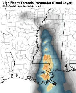
For south Mississippi, as of now, it looks like the best chance for severe weather will be to the west and southwest. That is shown by the Significant Tornado Parameter data above.
As for the timeline, that will be dependent on a host of factors, but should be reasonably nailed down. The line of storms is unlikely to speed up. So at this point a timeline ending around 6am is likely going to hold. But the question of “will storms fire up ahead of the line?” is one that we can’t fully answer yet.
The early data says, “No storms will develop,” but it is, after all, just the early data. In the graphic above, the vertical motion is absent over South Mississippi during the evening on Saturday, and doesn’t arrive until overnight and into Sunday morning.
And while my hunch agrees. a hunch isn’t a forecast.
So for now the timeline starts at 9pm, but could need to be pulled back to, as early as, 6pm
But again, we won’t really start to get a better handle on specifics until – likely – late tonight.
What will it do to my house?
No matter how you slice it, like I said above, pretty much all of South Mississippi is looking at heavy rain, a lot of lightning and gusty wind – at a minimum. Some of us will see wind gusts over 60mph. Others may be under a tornado warning. And, truly, we can’t rule out the possibility of a tornado or two.
In fact, as far as impacts as concerned, the CIPS Analogs out of Saint Louis University paint the best picture.

Recall that the CIPS Analogs looks back in history. It compares the atmosphere during past severe weather (or lack of severe weather) against what the model data is showing for an upcoming forecast. Notice it shows the region blanketed with severe weather reports with multiple storm reports happening during similar situations in the past.
That gives meteorologists higher confidence that severe weather is possible – and even likely for some – during this upcoming severe weather event.
Gimmie some Data!
Here is a slideshow of some of teh weather data used to put together this forecast…


