It’s a classic spring setup as the week closes across the high plains. A southwest flow aloft, moisture at the surface and the hint of a frontal boundary will supply enough juice to spark a few showers and mainly a few thunderstorms.
Quick Breakdown

Thursday, Friday and Saturday the Texas and Oklahoma panhandles will be “under the gun” so to speak for severe weather as a few of the right ingredients come together. As the area of high pressure in control over the area today, shifts east, it will allow for a southwest flow to develop. As moisture rushed in from the southeast, it will be a sufficient breeding ground for severe weather.
Right now, the main threats look to be damaging winds, large hail and flash flooding. And, in this particular scenario isolated tornadoes cannot be ruled out, either.
Location / Timing
Thursday
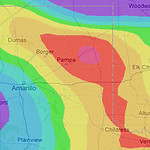
Right now it looks like the main bulk of the severe action will be relegated to the eastern and southeastern counties of the Texas panhandle and the most extreme sections of western Oklahoma. Storms will initiate between 2pm and 4pm and carry into the overnight hours. There is some indication, right now, that there could be thunderstorms that remain active overnight and into the early hours of Friday morning, as well.
On Thursday, because of the atmospheric conditions, the threat for damaging straight-line winds, large hail and tornadoes exist. In fact, some of the models suggest hail stones larger than two inches – bigger than a golfball – will be possible.
Friday
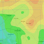
Generally speaking a wider area will need to remain alert to severe weather as the dryline sags back to the west. While places like Dalhart, Texas, Hereford, Texas and Guymon, Oklahoma looked safer on Thursday, Friday they will be fair game.
The forecast for Friday, though, will be a little trickier as it will depend on the action that develops on Thursday. Outflow boundaries from the previous night’s storms will dictate where/if storms develop and how fast they become severe.
On the flip-side, if Thursday is a very active day, it could “spend” the atmosphere. And it would be more difficult to get severe weather initiated as quickly.
Saturday
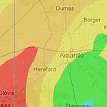
Saturday becomes even trickier. The weather models are suggesting that the better bet for severe thunderstorms will be in the western counties of the Texas Panhandle, but, because Saturday will play by the same rules as Friday, it gets difficult.
Yes, Saturday will also be dependent on the day prior, just as Friday will be. The tough part here is – a lot like long-range weather models – we are making predictions based on other predictions. Think of it like in math class and trying to solve: x + y = z. Where Thursday is “x” and Friday is “y” and “z” is what we are trying to predict for Saturday.
Right now we have a good feeling for what “x” might be.. but that doesn’t help us figure out what “Y” and “z” will definitely be.
Reminder
As always we’ll keep a close eye to it. Make sure to check back for details. It’s also a good idea to establish a severe weather plan and have a NOAA weather radio handy for updates about watches and warnings.


