This week is shaping up to be a wet one across much of the Southeast. Showers and storms are expected cover the Gulf Coast and most of Florida for at least the next three days. A frontal boundary has made its way to the South and has become stationary. This is one of the driving forces for the uptick of thunderstorm conditions coupled with strong daytime heating. This has also spun up a surface low pressure system that looks to bring heavy rainfall to the Central Gulf Coast.
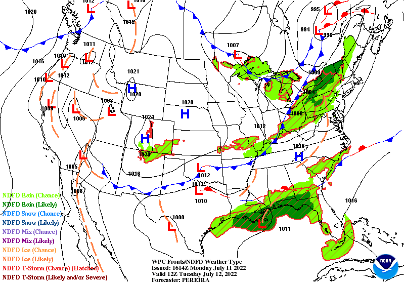
Tuesday will see showers and thunderstorms begin offshore in the morning before moving inland in the afternoon when daytime heating kicks in. Surface troughing is stretched over the region aiding the frontal boundary in producing these showers and storms. These features are also helping to bring in plenty of moisture from the Gulf with precipitable water values reaching 2″ near the coast. Behind the front to the north exists drier air where storm coverage will be limited in the Tennessee Valley. Eastern Georgia and South Carolina could see some scattered storms right on the boundary line.
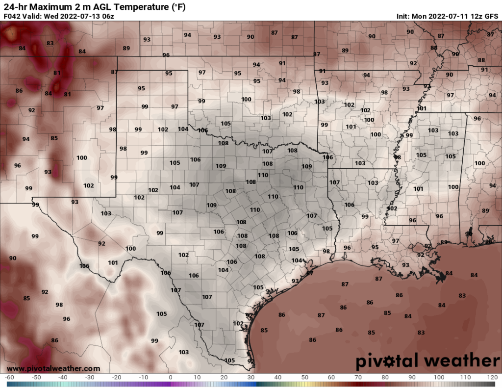
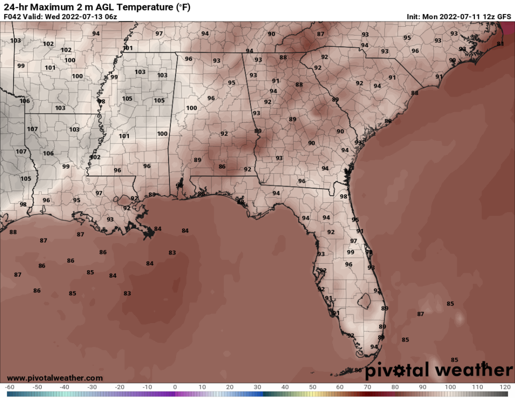
With the increased cloud coverage and rainfall, temperatures will be milder than our friends towards the western part of the region. Most places along the Eastern Gulf Coast will see highs in the mid-to-upper 80s. Low-to-mid 90s will be along the Eastern Coast. Around the Texarkana region, highs will be reaching 105F in some areas. Heat indices will also reach 110F in some parts indicating that heat advisories and warning will be in place for Tuesday.
Wednesday
Wednesday will see very similar conditions to Tuesday. The low pressure will slowly move inland bringing heavy rain with it. Regardless if this system gets an official tropical cyclone designation, it will bring flooding concerns to the Gulf Coast. The possibility of a named system will not diminish the impacts of heavy rainfall and flooding/flash flooding risks.
South of the I-10 corridor could see 4″-8″ of rainfall through the week with possible locally heavier amounts. Places more inland could get around 2″-4″ of rainfall throughout the week. Plenty of moisture is present still in the southern part of the region. Much of the region will see precipitable water values around 1.75″ while values of 2″-2.5″ will be present over the Central Gulf Coast and immediate inland areas. Weak flow aloft will allow for storms to be slow movers to accumulated lots of rain in a short period of time. Some of the stronger storms could contain gustier winds with them.
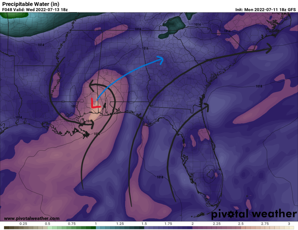
As the low meanders inland bringing heavy rainfall, Florida will see some sea-breeze convection kick off storms down the spine of the state. An approaching cold front from the north will increase storm chances near the Tennessee Valley. Isolated to scattered showers and storms can be expected near the Atlantic Coast.
Temperatures will be almost identical to Tuesday with mid-to-upper 80s in areas with increased cloud cover and precipitation. Highs in the 90s for much of the eastern side and extreme heat up to 105F over the Eastern Texas area. Heat advisories and warnings are likely to be issued in the Southeastern Plains.
Thursday
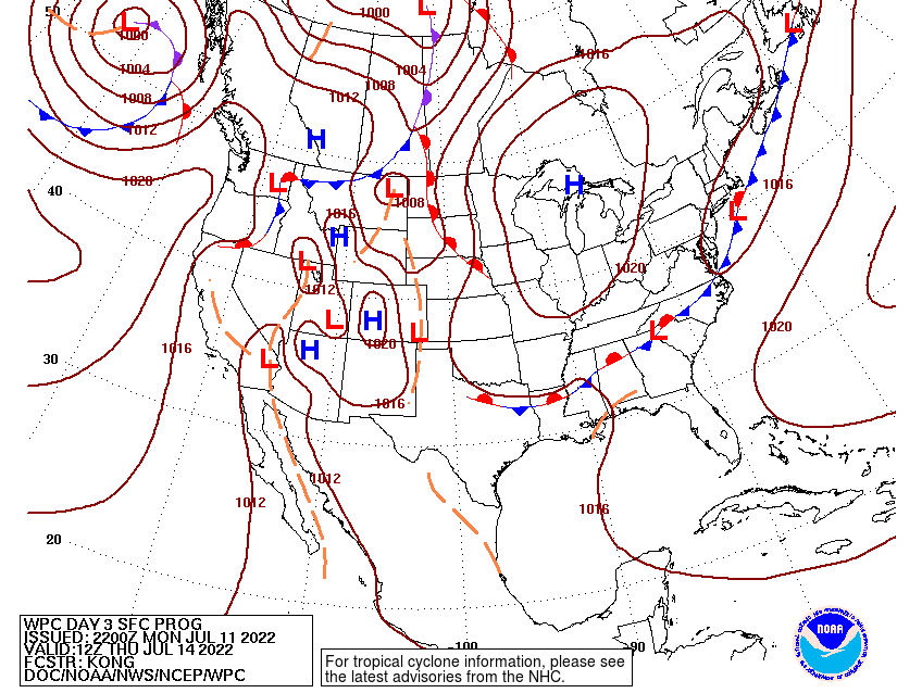
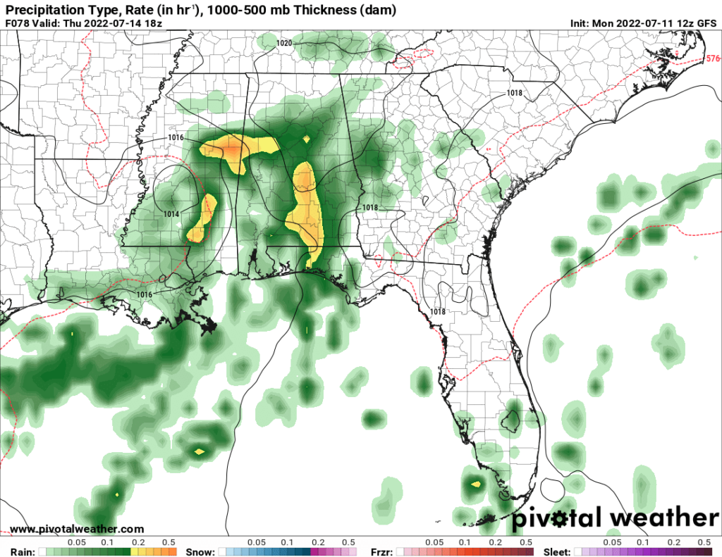
The same conditions will persist into Thursday with heavy rains in the central portion of the Southeast and extreme heat west towards Texas. An upper-level trough will inch closer to the region bringing another frontal boundary. Troughing will be stretched from the northeast to southwest stuck between two upper-level ridges. The main ridge over the Southern Rockies and the Bermuda High reaching westward towards the East Coast will lead to weak flow aloft.
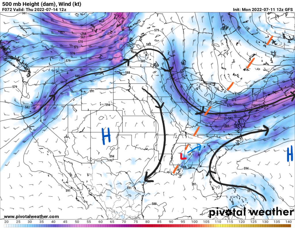
Weak flow aloft means that the low will persist over the area. There is no dominant steering for the system to move along quickly. Rather, the surface frontal boundary will help keep it pinned in the region. This increases the rain chances greatly for the Southeast. As the system evolves, it will eventually move northeastward towards the back half of the week.
Outside of the immediate low, scattered showers and storms are expected across the region in response to the front. Dewpoints reaching the 70s will help destabilize the atmosphere to allow the stronger storms to have a severe wind gust risk. SPC has included a marginal risk (1/5) for Northern AL/GA into the Carolinas on Thursday. With so much rain in the recent days, the soil will be very saturated; therefore, flash flooding remains an imminent risk for the Central Gulf Coast and more inland areas as well.
3 Day Forecast
| Dallas | ||
| Tuesday | Wednesday | Thursday |
| High: 105 | High: 105 | High: 102 |
| Low: 82 | Low: 80 | Low: 78 |
| Precip: None | Precip: None | Precip: None |
| Houston | ||
| Tuesday | Wednesday | Thursday |
| High: 102 | High: 97 | High: 96 |
| Low: 80 | Low: 80 | Low: 80 |
| Precip: 20-percent | Precip: 40-percent | Precip: 40-percent |
| New Orleans | ||
| Tuesday | Wednesday | Thursday |
| High: 88 | High: 83 | High: 84 |
| Low: 78 | Low: 76 | Low: 76 |
| Precip: 90-percent | Precip: 90-percent | Precip: 90-percent |
| Little Rock | ||
| Tuesday | Wednesday | Thursday |
| High: 99 | High: 94 | High: 93 |
| Low: 76 | Low: 72 | Low: 70 |
| Precip: 20-percent | Precip: None | Precip: None |
| Memphis | ||
| Tuesday | Wednesday | Thursday |
| High: 100 | High: 95 | High: 92 |
| Low: 76 | Low: 73 | Low: 73 |
| Precip: 20-percent | Precip: 20-percent | Precip: None |
| Birmingham | ||
| Tuesday | Wednesday | Thursday |
| High: 92 | High: 92 | High: 86 |
| Low: 74 | Low: 72 | Low: 70 |
| Precip: 20-percent | Precip: 60-percent | Precip: 60-percent |
| Atlanta | ||
| Tuesday | Wednesday | Thursday |
| High: 90 | High: 90 | High: 85 |
| Low: 74 | Low: 72 | Low: 70 |
| Precip: 30-percent | Precip: 70-percent | Precip: 70-percent |


