Happy Tuesday everyone and welcome to this tropical update! Today we will be going over the current status of the Atlantic and taking a look at one particular disturbance that is looking to affect the Gulf coast States over the coming week.
Like many of my prior tropical updates, we will begin with a look at the NHC 5-day outlook, a breakdown of the current conditions of the tropics, model prognosis of any disturbance(s), and then wrap it up with conclusions and the overall takeaway message.
Looking at the current outlook from the NHC, we can see the Atlantic currently shows one tropical disturbance with a low development potential of 30-percent within the next 5-days.
Currently from the NHC
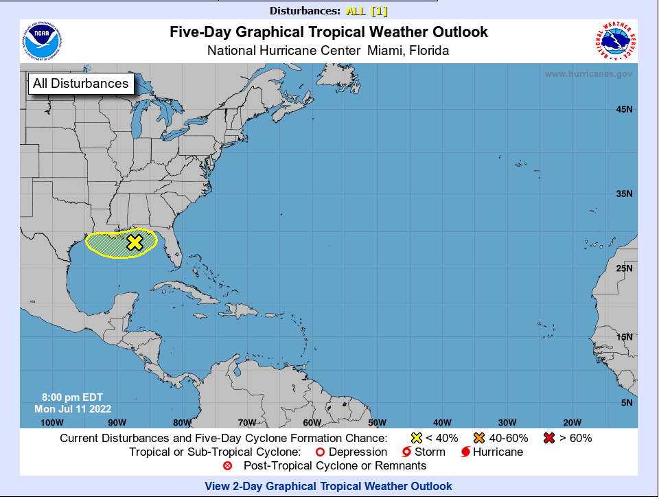
Despite the low chance, we will see further below that this disturbance has the potential to bring notable rainfall amounts to areas from Louisiana through the Florida Panhandle.
Current Tropical Conditions

Taking a look at the current Mid-level WV, there are three different areas of interest to note from the map.
Disturbance 1 is the one previously highlighted by the NHC, and the system that currently has the potential to being heavy rains to the Gulf coast. Disturbance 2 is a cluster of disorganized shower and thunderstorm activity out over the Northern Atlantic. Disturbance 3 is another area of disorganized showers and thunderstorms beginning to move out into the open Atlantic. As was previously mentioned, Disturbance 1 is the current area of interest and the only feature with the potential for development over the next week or so. This system also has the potential to impact the US, so its important to track this moving forward.

Taking a quick look at the upper-level troughs and ridges at 500MB, the most important things to pick out from this map would be the two subtropical ridges located to the east of Florida and to the west of Texas respectively. Those two ridges have the potential to “trap” any system in the Gulf, since there is no steering flow to move the system out of the area.

From the current wind shear across the Atlantic, we can see for disturbance 1, that the wind shear in the Gulf is low, compared to the Caribbean near Hispaniola where wind shear remains very high at near 50kts. The region just off the coast of Africa and to the south of the Cape Verde Islands is a region with moderate shear, with values upwards of 30kts. Just a quick reminder that wind shear negatively affects tropical systems and can lead to weakening / completely prevent development.

Looking at relative humidity which is another key indicator in tropical development, there is currently an abundance of dry air present across much of the Northern Atlantic, with a thin strip of moisture associated with the ITCZ or an area with increased thunderstorm activity just to the north of the equator. We can also see an area of moisture down through the Gulf coast which is associated with disturbance 1.
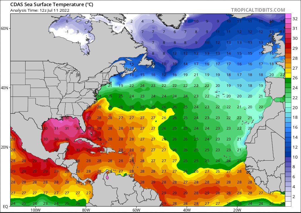
Current sea surface temperatures are well within range for tropical development, especially in the Gulf of Mexico where temperatures are currently 30C+(86F+). With our current disturbance in the Gulf however, current models do not show any major storm development and the NHC only has a 30-percent chance of development, so despite the warm ocean temperatures no major storm is currently expected to form.

Looking at the 850MB low level heights and vorticity, we can see that the GFS model has picked up on rotation development in the Gulf. This indicates a more organized system of showers and thunderstorms which will likely affect the Gulf coast.
Model Prognosis
As I stated previously, this section will focus mainly on the development and progression of disturbance 1 highlighted by the NHC, as the tropical Atlantic is forecasted to remain quiet besides this particular disturbance.
Starting off with the 500MB heights, we can take a look at how the upper-level steering pattern will develop over the next few days.

As I began to previously allude to, the system in question is likely stick around the area for a while if any formation comes about. This is due to the two subtropical ridges marked with the blue “H’s” causing a lack of upper-level steering flow. This is shown in many of the models where the system hangs around the area and then begins to move out by the end of the week into the weekend. This is what is giving the potential for higher rainfall totals as the system continues to funnel in moisture from the Gulf into the area for an extended period of time.
Some models are pushing for more development as compared to others, so as of writing this post given the 30-percent chance of development from the NHC and the disagreement among model guidance, any sort of robust system is unlikely to develop. Regardless, there will still be impacts from this system, mainly in the rainfall totals that are likely to occur across the Gulf coast States.


The American GFS model is showing a more organized system with stronger cyclonic vorticity indicating a stronger system, while the European model is showing a more loosely defined system with weaker levels of cyclonic vorticity, showing a weaker system in the area. This gives a difference between rain totals, which would be higher in the American model as compared to the European model.
Due to this difference in modeled strength of the system, the precipitation outcomes are quite different from model to model as expected.


Among these models, the NAM shows the potential for the greatest precipitation amounts, with Louisiana being the jackpot with localized amounts of 4″+ through Friday, and the European model (ECMWF) showing the least with the bulk of the heavier precipitation remaining offshore. This is just to give an example of how different the models are currently forecasting rain totals.
Currently, the WPC is on the higher side of rainfall totals, with rainfall through Monday being quite significant across the area.

The current WPC forecast shows Louisiana receiving up to 11″ of precipitation in spots, with southern portions of Mississippi, Alabama, and the Florida Panhandle receiving up to 10″ of precipitation. This is definitely something worth keeping an eye on, as flooding is always a potential when receiving such a high amount of rain.
Conclusions
With the possibility of areas along the Gulf coast receiving 10″ or more of rainfall over the coming week, it will be important to continue to monitor tropical updates and look out for any flood watches or warnings put out by your local NWS office. Despite the NHC only showing a 30-percent chance of system development, the enhanced moisture this disturbance will bring off of the Gulf of Mexico could be enough to lead to heavy precipitation across the area. Therefore, continue to lookout for future discussions to monitor any changes, good or bad, that happen over the next few days.


