Good morning folks! Today’s temperatures will be about 5F cooler than they were yesterday, reaching as high as 88F. These lower temperatures are being caused by an area of disorganized thunderstorms located just off the Gulf Coast, which is expected to bring heavy rainfall (especially closer to the coast) both today and the next several days. Southerly winds at around 5mph to 10mph at the surface will usher in plenty of moisture with dew points reaching 75F-to-77F, causing heat indices to reach the mid 90s.

The 500mb ridge hasn’t moved much in the past few days and is expected to remain over the West/Central U.S. for at least the next 7 days. This pattern is causing winds at the 500mb level to be rather weak over the region, which will allow for the Gulf disturbance to linger for the next several days. This disturbance was given a 10-percent chance of cyclone development within the next 48 hours and a 30-percent chance within the next 5 days by the National Hurricane Center, but heavy rainfall is expected to be the main impact.

The above image displays how much rainfall is expected to fall over the next several days up through Sunday morning. The coast of LA/MS/AL is expected to be especially wet with rainfall amounts generally in the 3″-to-5″ range, with locally greater amounts in excess of 7″. This will all be possible not only because of the disturbance, but the high precipitable water (PWAT) values associated with it. PWAT values will exceed 2″, reaching as high as 2.5″ over the region, which is very supportive of heavy rainfall.
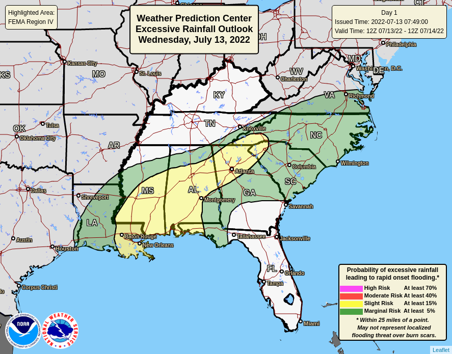
This atmospheric disturbance, abundance of moisture, and instability have all aligned over the region and has warranted a slight risk of excessive rainfall for the coast today. Some of the pop-up thunderstorms associated with the disturbance could prove hazardous as rainfall rates up to 2″ per hour are possible. These rates can create flash flooding, reduce visibility, and cause water to temporarily pile on the surface of roads making hydroplaning more likely; please keep it slow if driving through one of these downpours!
Day to Day Forecast
Today
Partly cloudy with a 80-percent chance for showers and thunderstorms. Highs in the mid to upper 80s. Heat Index values around 95F.
Tonight
60-percent chance for showers and thunderstorms. Lows in the lower 70s.
Thursday
Mostly cloudy with a 80-percent chance for showers and thunderstorms. Highs in the mid to upper 80s. Heat Index values around 95F.
Thursday Night
60-percent chance for showers and thunderstorms. Lows in the lower 70s.
Friday
Partly cloudy with a 70-percent chance for showers and thunderstorms. Highs in the mid to upper 80s. Heat Index values around 95F.
Friday Night
40-percent chance for showers and thunderstorms. Lows in the lower 70s.
Saturday
Mostly sunny with a 70-percent chance for showers and thunderstorms in the afternoon/evening. Highs in the mid to upper 80s.
Saturday Night
60-percent chance for showers and thunderstorms. Lows in the lower 70s.
Sunday
Mostly cloudy with a 60-percent chance for showers and thunderstorms. Highs in the upper 80s. Heat Index values around 95F.
Sunday Night
40-percent chance for showers and thunderstorms. Lows in the lower 70s.
Monday
Mostly sunny with a 60-percent chance for showers and thunderstorms in the afternoon/evening. Highs in the upper 80s.
Monday Night
30-percent chance for showers and thunderstorms. Lows in the lower 70s.
Tuesday
Mostly sunny with a 40-percent chance for showers and thunderstorms in the afternoon/evening. Highs in the upper 80s.
Tuesday Night
Partly cloudy. Lows in the mid 70s.


