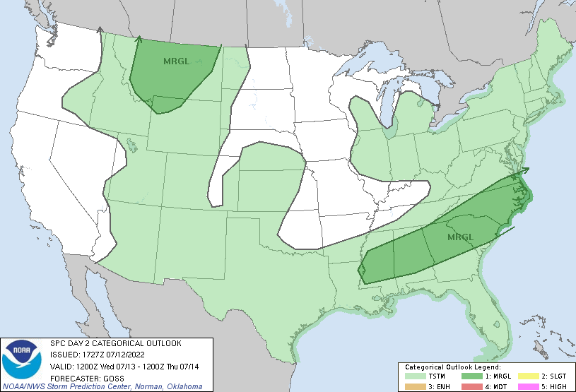
The forecast period begins with a marginal severe threat in SW Mississippi. The main threat would be a small chance for damaging winds. Moderate instability and slightly elevated shear have allowed a small severe risk to materialize. That being said, marginal is the lowest severe risk aside from no defined severe risk at all, so any severe weather would likely be isolated. Additionally, due to low amounts of vertical motion and forcing (which is related to background vertical motion that makes it easier for storms to develop), the storms will probably be fewer in number and isolated.
The next few days after this will see temperatures in the lower 90s and upper 80s throughout the region with low precipitation chances. On Saturday night, however, a trough is expected to move into the area. This trough will bring cooler air. The cold front moves in Saturday night, resulting in a high chance for thunderstorms.
This cold front will also bring more pleasant temperatures. The next few days may only see highs in the mid 80s. The rain chances will also be elevated for at least the first few days after the cold front.
Day to Day Forecast
Wednesday
Partly cloudy with a slight chance of thunderstorms. Storms could contain gusty winds. Highs in the low to mid 90s. E winds shifting to S at 5-10 mph. Chance of rain 30 percent.
Wednesday Night
Mostly cloudy with a chance of thunderstorms. Lows in the mid 70s. Chance of rain 40 percent.
Thursday
Partly cloudy with a slight chance of thunderstorms. Highs in the upper 80s. Chance of rain 30 percent.
Thursday Night
Mostly cloudy. Lows in the lower 70s. Chance of rain 10 percent.
Friday
Mostly sunny. Highs in the lower 90s. Chance of rain 20 percent.
Friday Night
Partly cloudy. Lows in the lower 70s. Chance of rain 10 percent.
Saturday
Partly cloudy with a chance of thunderstorms later in the day. Highs around 90. Chance of rain 40 percent.
Saturday Night
Thunderstorms. Lows in the lower 70s. Chance of rain 80 percent.
Sunday
Showers and thunderstorms in the morning, then still a chance for thunderstorms in the afternoon. Highs in the mid 80s. Chance of rain 80 percent.
Sunday Night
Mostly clear. Lows in the lower 70s. Chance of rain 10 percent.
Monday
Thunderstorms. Highs in the mid 80s. Chance of rain 80 percent.
Monday Night
Mostly cloudy with a chance of thunderstorms. Lows in the lower 70s. Chance of rain 50 percent.
Tuesday
Partly cloudy with a slight chance of thunderstorms. Highs in the mid 80s. Winds SW at 5-10 mph. Chance of rain 30 percent.
Tuesday Night
Mostly clear. Lows in the lower 70s. Chance of rain 20 percent.


