Good morning, folks, and happy Hump Day! As with Sincere’s discussion yesterday, the main story is still the chance for heavy rain across portions of southeastern Mississippi and southwestern Alabama.
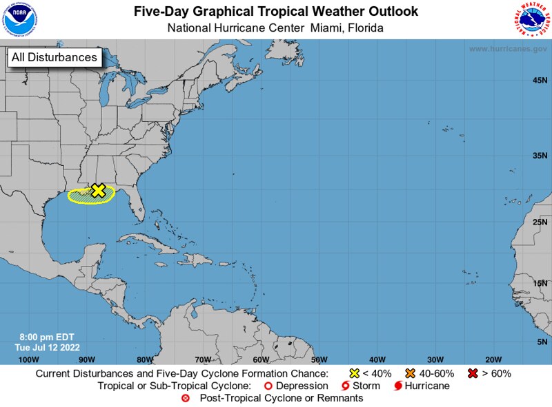
This morning, the National Hurricane Center is still monitoring an unorganized region of showers and thunderstorms in the northern Gulf of Mexico for the potential to develop into a tropical depression or weak tropical storm. The NHC has only given this region a 10-percent chance to develop due to its proximity to land and limited time left over the warm waters of the Gulf. Regardless whether or not this system develops, the impacts will remain the same, with an enhanced threat for locally heavy rainfall across some regions in the Southeast, including southeastern Mississippi and southwestern Alabama.
But, before we get in too deep with this system, let’s take a look at the current synoptic picture to see what else is affecting the weather in our region today.
Current Synoptic Picture

It’s great to start off one of these discussions and to not see a huge ridge just sitting over the Southeast. In the past month or so, a formidable ridge has been drifting about the southern half of the United States, with the Southeast experiencing some very hot weather so far this summer.
Well, right now the center of this upper-level ridge has shifted well to our west over the Four Corners region. In fact, at the moment the Southeast is feeling the affects of some troughing due to an upper-level low well to our north in eastern Canada.

A little bit closer to the ground, this SPC Mesoscale Analysis product let’s us see the 700mb geopotential heights across the region, as well as the average mid-level relative humidity, shown by the green shading. At the moment, a swath of lowered heights and an associated plume of greater moisture is sitting over the Southeast, in a ribbon extending from the central Gulf of Mexico, onshore to southeastern Louisiana, southeastern Alabama, the Florida Panhandle, central Georgia, and all the way into South Carolina. Embedded in this tongue of moisture are some scattered showers and thunderstorms associated with the disturbance in the northern Gulf of Mexico we mentioned earlier.

The energy associated with this disturbance can be seen pretty well with a view of the mid-level cyclonic vorticity, which shows enhanced vorticity across southern Louisiana, southern Mississippi, southeastern Alabama, the Florida Panhandle, and into parts of Georgia – exactly where the moisture plume is located. Of course, this is no coincidence and it’s what’s been responsible for the unsettled weather here recently. This unorganized disturbance that originated as a stalled boundary will continue to bring the chance for rain and thunderstorms to the region throughout the week.

Finally, let’s take a look at some infrared satellite imagery from earlier this morning. The cooler temperatures correspond to higher cloud tops, which can show us where there are clouds and convection across the region. Near the Gulf Coast, there is some cloudiness associated with the disturbance offshore, as well as a complex of thunderstorms near the Mississippi-Tennessee-Alabama tri-point.
This leaves a good portion of the region cloud-free this morning, a condition that will likely persist into the afternoon.
Slightly Above-Average Today, with Rain Coming Later This Week
Even with upper-level ridge far-removed from the region, and with 500mb heights about average for this time of year, temperatures will still manage to climb into the mid-90s, a few degrees above average for this time of year.

These hot temperatures, as well as dew points in the low-to-mid-70s for much of the region will support heat indices between 100 and 105 for most areas across southeastern Mississippi and southwestern Alabama.


For this reason, the local National Weather Service offices have issued Heat Advisories for parts of Mississippi, where there exists the greatest threat for apparent temperatures over 100F.
As the day progresses, the change for some thunderstorms approaching from the north with the passage of a weak boundary increases.

As this boundary approaches the disturbance just offshore, Thursday will bring some much more widespread rain across the region. As this disturbance hangs around through the end of the week, the chances for showers and thunderstorms will remain high.

Through Friday evening, models are in agreement that up to an inch of rain will fall across the region, mostly falling tonight through Friday morning, with the chances for rain starting to diminish Friday night.
Drier for the Weekend, then More Rain into Next Week
By the time the weekend roles around, we may be in a sweet spot stuck between two regions of unsettled weather for a time.

After the energy associated with the stalled-boundary moves back to the south out of the region, the upper-level ridge attempts to build into the northern and central parts of Mississippi and Alabama, which will help to keep temperatures around-, if not slightly above-, average, and to reduce the risk of rain to the chance of an afternoon storm, as opposed to widespread showers and thunderstorms.
By Sunday afternoon, however, an approaching disturbance will put an end to our quick break from the clouds and rain. Early next week, an upper-level cut-off low will bring the chance for more clouds and rain to much of the Southeast – with this feature weakening some by late next week and drifting about near the shores of the Gulf of Mexico.

Day-to-Day Forecast
Today
Mostly sunny skies early, with a 60-percent chance of an afternoon or evening thunderstorm. High temperatures in the mid-90s are likely, with heat indices approaching 105F.
Thursday
Cloudy with an 80-percent chance of thunderstorms throughout the day. High temperatures in the mid-to-upper 80s are likely.
Friday
Party cloudy skies, with a 40-percent chance for an afternoon shower or thunderstorm. High temperatures around 90F are likely.
Saturday
Partly cloudy skies, with a 30-percent chance for an afternoon shower or thunderstorm. High temperatures in the low 90s are expected.
Sunday
Partly cloudy skies early, with increasing cloudiness expected throughout the day, with a 50-percent chance for an afternoon shower or thunderstorm. High temperatures in the upper-80s to the low-90s are expected.
Monday
Mainly cloudy, with some peaks of sun possible throughout the day, with a 70-percent chance of rain or thunderstorms throughout the day. Expect high temperatures in the mid-to-upper 80s.
Tuesday
Mainly cloudy, with some peaks of sun possible throughout the day, with a 70-percent chance of rain or thunderstorms throughout the day. Expect high temperatures in the mid-to-upper 80s.


Need to show the day and time each image represents. Zulu time means NOTHING as far as knowing when what happens when.