As another storm system swings by to our north, it will open the door for showers and storms to develop Saturday afternoon. Most of these will be regular storms. Some may be on the strong side. But the severe weather threat doesn’t really arrive until we get into the overnight hours on Saturday night into Sunday morning.
Timeline in a Nutshell…
Saturday morning: Increasing clouds, temperatures in the 50s and 60s
Saturday afternoon: Hit and miss showers and storms. Severe weather not anticipated at this point. A strong storm is possible with heavy rain, frequent lightning, gusty wind and small hail. Temperatures around 70.
Saturday evening: A lull in the action for some of the area. Showers and storms become fewer and farther-between. Temperatures falling back into the 60s.
Saturday night late / Early Sunday morning: Isolated supercell thunderstorms possible ahead of the line of strong-to-severe storms. The main concerns are heavy rain, frequent lightning, damaging wind gusts, hail up to the size of quarters, and the possibility of a brief, weak tornado.
Sunday morning: Clearing skies behind the storms. Temperatures around 60.
The Sciency Breakdown
As the system swings this direction, the atmosphere isn’t going to be oriented in an “A-Typical” way – and that may be good news for us. Generally, when we get areas of low pressure that pass by between (roughly) Oklahoma City and Nashville, the cold front that passes by sets storms up to travel in the “A-Typical” southwest to northeast direction.
This time, storm motion may actually be a lot like the last storm system: west to east. or even west-northwest to east-southeast. This would decrease the tornado threat and increase the hail and wind threat.
Why does that matter?
While the line of thunderstorms may bring with it heavy rain and gusty wind, often meteorologists are more concerned about the Supercell Thunderstorms – either on their own (called “discrete” storms) or embedded (hidden) within the line.
Supercell thunderstorms are the most prolific severe weather producer. The storms use a conveyor belt within them. They need warm air to come in from the south to feed it, it gets pulled up into the storm and then cooled, and dropped on the north side of the storm. And when they travel from SW to NE, you can think of it like Pac-Man chomping up all the warm air ahead of him.
And, if I can continue with this analogy, if Pac-Man is facing a different direction than he is traveling, it is tough for him to chomp down food, right?
That is what happens to supercells when they start moving a different direction than SW to NE. It becomes more difficult (though not impossible) for the storms to have easy access to warm moist air. And the conveyor belt has a more difficult time becoming established.
This means that while storms will still pack a punch, and will still have the chance to be severe… But it may be a bit more difficult for strong tornadoes to develop.
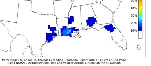
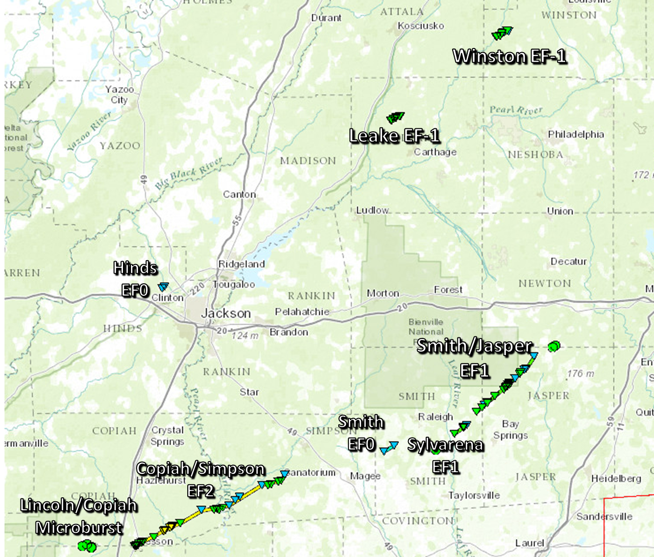
The CIPS Analogs highlights this pretty well. It shows that while looking at the Top 15 most similar situations, there is – historically – a tornado less than 10-percent of the time. And there were only two of the Top 15 that produced tornadoes here. The most recent one was February 15, 2016. The map below highlights that on that day, while there were multiple tornado reports in our area, most of the reports came from just two storms.
Also notice that most of the tornadoes were either EF-0 or EF-1. That said, even that event, storms were still moving in the “A-Typical” way, from SW to NE. In our setup, that will not be the case. Just to drive the point home, speaking of CIPS, it shows that only six of the Top 15 times the atmosphere looked like this, did we get severe weather. And when we did, it was mainly wind and hail.
Bottom Line
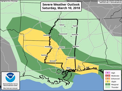
Be prepared for some severe weather overnight Saturday and into Sunday morning. The main threat will be rain and wind. But we can’t rule out the possibility of a tornado. This isn’t a widespread severe weather outbreak. There may only be a few storms that are severe. So, as it looks like right now, there isn’t any reason to lose sleep over this threat.
Reminder!
You can always get the latest forecast discussion from the National Weather Service here. You can always get the latest information on the severe weather threat here.


