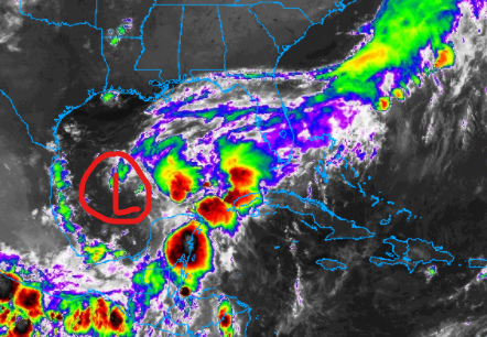
Interesting to see that the National Hurricane Center hasn’t issued any products designating Invest 92L as “Potential Tropical Cyclone One” yet. I’m sure there is a good reason, but we are definitely within the timeframe where this should be a thing.
The NHC created the “PTC” moniker so that it could distribute forecast cones and issue watches and warnings on systems that were going to make landfall within 48 hours but were not – yet – well-organized enough to deserve Tropical Depression status.
Invest 92L would seem to fit that description.

The latest guidance from the models shows a slightly different solution this morning. Not totally surprising, but also probably not totally accurate, either. As you guys have probably learned over the years from reading this blog (or watching me on TV) these models really do struggle to accurately forecast track and intensity when any system doesn’t have a defined low-level center yet.
The models need something to grab ahold of, and there just isn’t enough there. A good comparison might be to think of that old fable of Rapunzel. The models are screaming, “Rapunzel, Rapunzel! Let down your hair!” and instead of getting a full head of hair (well organized system) the models are getting a single strand of hair (Invest 92L).
Tough to climb up the side of a tower (make an accurate forecast) using a single strand of hair.
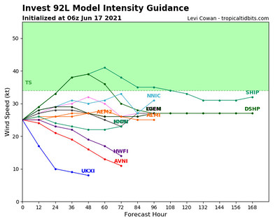
And until there is a better-organized system, a lot of the models are going to struggle with a specific solution.
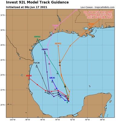
You can see the spread between the track guidance has gotten wider and the track has shifted farther west. I don’t know that I agree with that, but it will depend on where the low-level center is pulled by where convection fires up today. I find it unlikely that the system will be pulled to the NW that far, but given where the low-level center is this morning and the general nudging it seems to be getting fromt eh southeast, it can’t be totally ruled out.
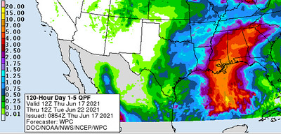
Either way, the biggest impact will be rainfall. The Weather Prediction Center is already carving out a Moderate Risk for flash flooding on Day 3 (Saturday).

Day-to-Day Forecast
With all of the tropical riff-raff, I didn’t have as much time to deep dive into the forecast. There is a chance for a front to move through next week, but I didn’t take as much time to look it over this morning.
Today
Mostly sunny. Highs in the lower 90s.
Tonight
Partly cloudy. Lows around 70.
…. Invest 92L influence begins
Friday
Increasing clouds with a few showers and storms possible – mainly south. Highs in the upper 80s. The chance for rain is around 40-percent.
Friday Night
Mostly cloudy with passing showers and storms. Lows in the lower 70s. Southeast winds 5 to 15 mph. The chance of rain 60-percent.
Saturday
Mostly to fully cloudy with passing showers and storms. Highs around 80. Southeast winds 10 to 20 mph. Gusts up to 30 mph. The chance of rain 80-percent.
Saturday Night
Rain continues. Wind still between 10 and 15 mph. Mostly cloudy. Lows in the lower 70s. The chance of rain 80-percent.
Sunday
Mostly cloudy with passing showers and storms in the morning. Then drier with only isolated showers and storms by afternoon. Highs in the mid 80s. The chance of rain 70 percent.
…. Invest 92L influence ends
Sunday Night
Partly cloudy. Lows in the mid 70s.
Monday
Partly cloudy with summertime-style storms possible. Highs in the upper 80s. The chance of rain 60 percent.
Monday Night
Partly cloudy. Lows in the mid 70s.
Tuesday
Mostly cloudy with more storms possible. Highs in the mid 80s. The chance of rain 40-percent.
Tuesday Night
Mostly cloudy. Lows in the lower 70s.
Wednesday
Partly cloudy with a 40-percent chance of showers and thunderstorms. Highs in the mid 80s.


I agree … it ‘is’ strange that they have ‘this’ system that they seemingly are hesitating declaring it a PTC but, yet, give a cluster of t’storms a name. Strange, it is.