(UPDATE: 10:00 AM)
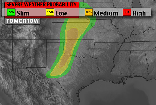
Latest models continue to show storms struggling to develop in the daytime heat on Saturday. That said, there are a few models that are changing their tune and coming around to the idea of storms firing along the Texas and Oklahoma border between Childress, Texas and Woodward, Oklahoma around 6 pm.
If these storms fire, they would be strong to severe. ain threats owuld be high wind and large hail.
(ORIGINAL 5:00 AM) Alliteration aside… Sorry, I couldn’t resist one last one. But seriously, there is a chance for severe weather on Saturday, though, there may be a good reason not to change your afternoon plans.
In fact, if you’re reading this in the Texas and Oklahoma panhandles, central Kansas, central and western Oklahoma and north Texas, don’t cancel you Saturday softball game just yet.
Right now, most of the computer weather models show the right ingredients for severe weather on Saturday afternoon. There are high CAPE values, plenty of shear, abundant moisture and the beginnings of “opening” in the atmosphere aloft.
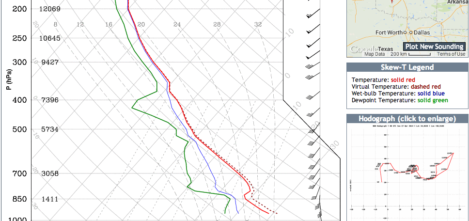
What the models also show is a stout “cap of warm air” in the mid-levels of the atmosphere.
This is good news and bad news. The good news is that the “cap” would hold a vast majority of storms from developing.
The bad news is if a storm was to develop and “break the cap” as we say, it would become severe and the aforementioned ingredients would support large hail, damaging winds and the possibility of a tornado.
Regardless of what happens, this scenario will be watched closely.
That said, most of the Friday morning computer weather model output holds off introducing any showers and thunderstorms until late Saturday night and into Sunday. And then breaks out severe weather across eastern Oklahoma and Texas, Arkansas and Missouri.
I’ll have more details and I’ll try to post a full severe weather breakdown this afternoon. But, as it looks right now, you might want to keep that tee time. Just make sure you can take cover if any storm is to develop.


