Another week. Another High Risk from the SPC. This is going to be another dangerous day across parts of the Southeast. Even ‘Stefon’ from SNL is paying attention

The “HOD’S” (hodographs) and “CAPES” (instability) are both looking rather robust this morning on the 12z soundings from local NWS offices.
Jokes aside, the Storm Prediction Center has issued a High Risk for sections of Mississippi, Alabama and Tennessee for today. This is a “5” on the 1-to-5 scale where “5” is the highest risk for the most significant severe weather.

Here is a look at their discussion:
…Synopsis…
In mid/upper levels, a longwave trough will be maintained over the western CONUS, as a strong shortwave trough and related speed max dig south-southeastward across the interior Northwest, and a formerly basal trough ejects northeastward.
The latter trough is evident in moisture-channel imagery over the southern High Plains to the Big Bend region of TX, and will move to MO/AR by 00Z. By 12Z, this feature should reach Lake Erie and OH. This trough will pack the height gradient to its southeast enough to yield 110-130-kt 250-mb flow and 80-100-kt 500-mb winds over much of the Mid-South, and Tennessee/Ohio Valleys today and this evening.
The associated surface low-pressure area was analyzed at 11Z across western AR to northwestern LA, still poorly consolidated around areas of rain-cooled air. A cold front was drawn from northwestern LA across southeast TX the middle TX Coast and deep south TX. A “synoptic” warm front arched from the low-pressure area over western/middle TN and northern GA. A marine warm front — denoting the northern rim of the most fully modified Gulf return flow/warm- sector air mass — was drawn over northern LA, central MS, and southwestern AL, and will move northward over the Mid-South and Tennessee Valley through the day.
The surface cyclone should become better-defined and deepen as it moves northeastward across AR and southeastern MO today. By 00Z, the low should reach southern IL in the MVN/BLV area, with cold front across western TN, central MS, and southern LA.
By 12Z tomorrow, the low should reach western Lake Erie or adjoining southwestern ON, with cold front across western PA, the Blue Ridge area of western VA, the western Carolinas, western GA, to the MOB/PNS vicinity and northwestern Gulf. Only minor peripheral adjustments were made to the previous outlook lines for convective/boundary placement on the west side, and elsewhere, updated analyses and guidance since last issuance. The core threat area is essentially unchanged for now.
…Southeast to Ohio Valley…
Scattered to numerous thunderstorms are expected from midday through afternoon over parts of the lower Mississippi Valley region and Mid-South. This activity will race northeastward while maturing into cyclic supercells and bow echoes. Tornadoes are the main concern (some strong to violent).
Also, severe nontornadic winds may exceed 65 kt locally, and sporadic large, damaging hail also is possible. A relatively undisturbed low-level warm sector with rich moisture should shift further inland along and south of the marine warm front, with a very favorable buoyancy/shear pattern over a broad area.
Surface dew points in the upper 60s to low 70s F already are common over central/southern LA, southern MS and southwestern AL. This moisture will spread northward over at least the “high” and “moderate” areas today, where the southern and eastern parts of strongest deep-layer winds will overlap the greatest low-level instability. There, diurnal heating will remove MLCINH from midday onward, contributing to ready thunderstorm development, both in the destabilizing warm sector and near the cold front.
Meanwhile, expect strengthening deep shear and large, almost ideally shaped low-level hodographs formed in part by a wide, 60-70-kt LLJ. Accordingly modified RAOBs and forecast soundings yield peak MLCAPE of 2000-2500 J/kg, amidst 65-75-kt effective-shear vectors, and effective SRH values of 400-700 J/kg.
This is an uncommon, upper-echelon parameter space. In such an environment, any relatively discrete supercells will be capable of multiple tornadoes, some long-tracked and strong to violent (EF2-5 possible), with considerable destructive potential.
A very moist boundary layer also will reduce potential cold-pool/outflow strength via less subcloud evaporation, so that even closely spaced storms may have substantial tornado threats. Forecast wind fields and model soundings reasonably suggest any sustained supercells and their tornadoes will be fast-moving (45-55 kt), with individual tornado paths nearly as long in miles as their duration in minutes.
At any given time, boundary-layer instability should lessen with northward extent across the Ohio Valley. Nonetheless, warm advection will help to spread at least weak surface-based buoyancy over the region prior to cold frontal passage, with similarly intense deep shear as farther south.
As such, the threat for severe winds and tornadoes in particular will extend into tonight, spreading up the Ohio Valley and toward the central/southern Appalachians. Overall severe potential should lessen to “slight” and “marginal levels” late tonight near the Appalachians as the mid/upper system and surface low move away from remaining optimal instability, and flow aloft becomes more boundary-parallel.
Courtesy: SPC.NOAA.GOV
The “tl;dr” version…
“Today is going to be a potentially very bad, bad day across areas of Mississippi, Alabama and Tennessee due to the abnormally robust atmosphere capable of producing and sustaining long-track and powerfully strong tornadoes within a space that is going to promote the development of supercells and subdue the tendency for storms to congeal and form into a line.”
Hi-res guidance not doing well
Within the abnormal environment, it is not surprising that the hi-res guidance has been struggling to develop storms within the reflectivity output. While many of the severe weather parameters are above the 75th percentile, sometimes models have a difficult time turning that into a picture that is a good reflection of the potential outcome.
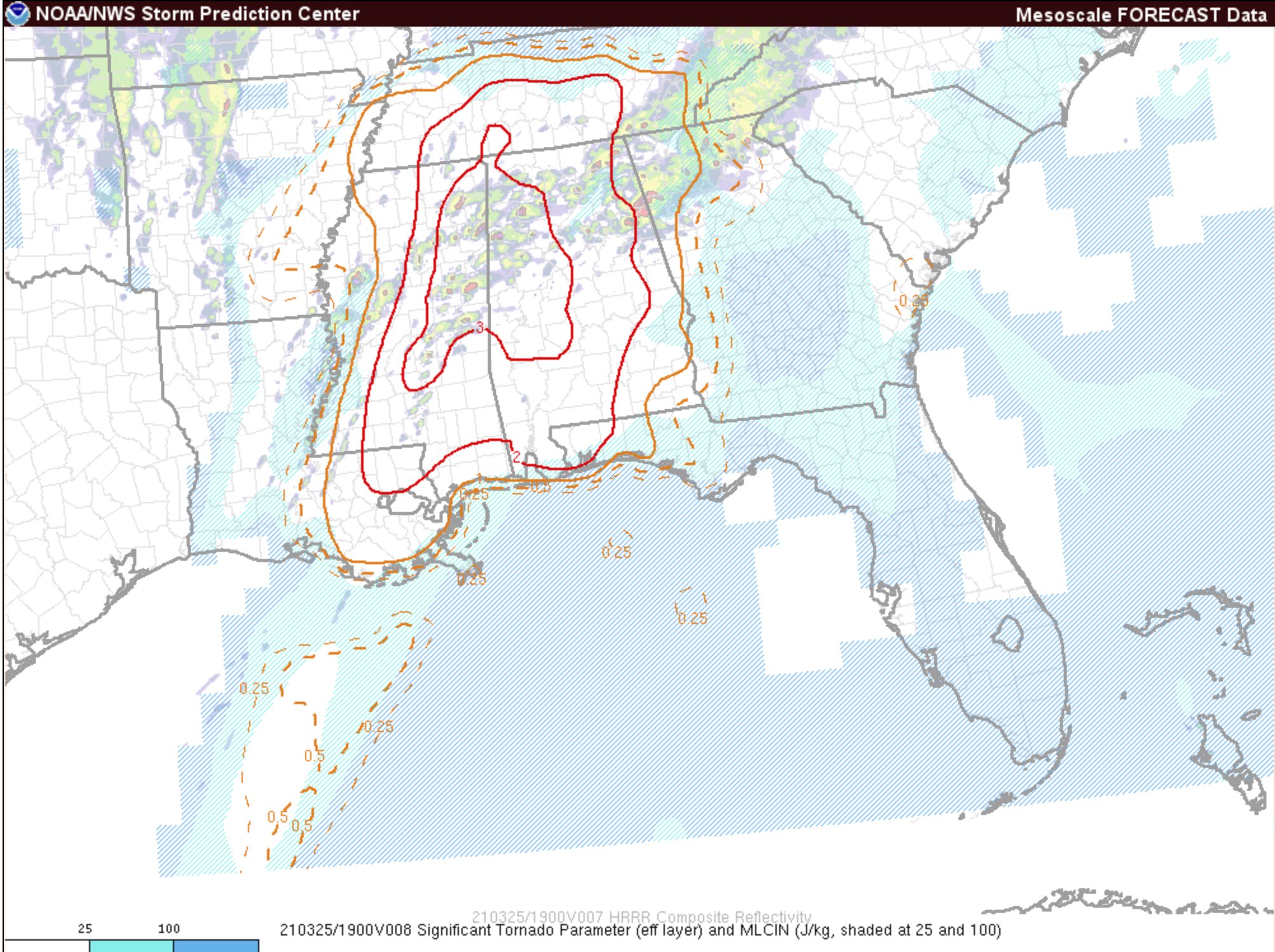
The image above is the SigTor parameter pulled from the SPC’s mesoanalysis site for this afternoon between 1p and 3p. It highlights the thing I’ve been mentioning the last few days which is a thumb of ‘potentially tornado-producing atmosphere’ poking down across some of our western counties.
Because of that, I think my original forecast for areas of a higher concern for seeing the stronger storms across south Mississippi still holds.

The red circles above are canals where the atmosphere may line up to provide a potentially potent parameter space (that’s a lot of p’s) for the stronger storms to develop. And the “stronger storms” on a day like today would be storms capable of producing heavy rain, frequent lightning, wind gusts up to 70mph, hail up to the size of golf balls, and a strong tornado.
This doesn’t mean that everyone in the red circled areas will definitely see a strong tornado.
It is just highlighting that those areas are the areas where the development of those types of things will be the easiest to accomplish for the atmosphere.
South Mississippi Breakdown – forecast holds
This is not going to be a rains-all-day and storms-are-all-over kind of day. In fact, this is looking less, and less, like an event where everyone sees severe weather. Instead, there will be a few storms that turn severe, and everyone else sees some rain, thunder and wind at times.
There is even the outside shot that some folks stay dry all day.
Taking a look at your likelihood of seeing any type of storm activity…
EVERYONE:
– Chance for storms
– Warm & humid
– Breezy
A LOT OF SPOTS:
– Heavy rain at times
– Frequent lightning
– Wind gusts up to 40mph
SOME SPOTS:
– Heavy rain at times
– Frequent lightning
– Wind gusts up to 50mph
– Dime-sized hail
FEW FOLKS:
– Heavy rain at times
– Frequent lightning
– Wind gusts up to 70mph
– Quarter-sized hail
– Tornado (perhaps a strong tornado)
Looking at the counties of southern Mississippi, here is a county-by-county timeline and breakdown of what to expect on Thursday. And while the timeline is broken down into chunks from 8a-12p, 12p-6p, and 6p-10p…. keep in mind that the window of opportunity for the strongest storms to START to develop is around 11am. So there is some overlap.
NORTHERN COUNTIES
Simpson County
8a-12p — Passing clouds with isolated storms developing. Strong to marginally severe storms will be possible during this time with heavy rain, frequent lightning, wind gusts up to 60mph, up to dime-sized hail and the potential for a brief tornado.
12p-6p — Isolated strong to severe storms possible. Storms may produce heavy rain, frequent lightning, wind gusts up to 70mph, hail up to the size of golf balls, and a chance for a tornado (up to EF3 in strength).
6p-10p – Isolated storms coming to an end. Followed by a thin line of storms moving through the area during this time. Storms may be strong with heavy rain, some lightning, and gusty wind.
Smith County
8a-12p — Passing clouds with isolated storms developing. Strong to marginally severe storms will be possible during this time with heavy rain, frequent lightning, wind gusts up to 60mph, up to dime-sized hail and the potential for a brief tornado.
12p-6p — Isolated strong to severe storms possible. Storms may produce heavy rain, frequent lightning, wind gusts up to 70mph, hail up to the size of golf balls, and a chance for a tornado (up to EF3 in strength).
6p-10p – Isolated storms coming to an end. Followed by a thin line of storms moving through the area during this time. Storms may be strong with heavy rain, some lightning, and gusty wind.
Jasper County
8a-12p — Passing clouds with isolated storms developing. Strong to marginally severe storms will be possible during this time with heavy rain, frequent lightning, wind gusts up to 60mph, up to dime-sized hail and the potential for a brief tornado.
12p-6p — Isolated strong to severe storms possible. Storms may produce heavy rain, frequent lightning, wind gusts up to 70mph, hail up to the size of golf balls, and a chance for a tornado (up to EF3 in strength).
6p-10p – Isolated storms coming to an end. Followed by a thin line of storms moving through the area during this time. Storms may be strong with heavy rain, some lightning, and gusty wind.
Clarke County
8a-12p — Passing clouds with isolated storms developing. Strong to marginally severe storms will be possible during this time with heavy rain, frequent lightning, wind gusts up to 60mph, up to dime-sized hail and the potential for a brief tornado.
12p-6p — Isolated strong to severe storms possible. Storms may produce heavy rain, frequent lightning, wind gusts up to 70mph, hail up to the size of golf balls, and a chance for a tornado (up to EF3 in strength).
6p-10p – A few severe storms may linger in the area through 7p. After that, isolated storms coming to an end. Followed by a thin line of storms moving through the area during this time. Storms may be strong with heavy rain, some lightning, and gusty wind.
HIGHWAY 84 CORRIDOR
Lawrence County
8a-12p — Passing clouds with isolated storms developing. Strong to marginally severe storms will be possible during this time with heavy rain, frequent lightning, wind gusts up to 60mph, up to dime-sized hail and the potential for a brief tornado
12p-6p — Isolated strong to severe storms possible. Storms may produce heavy rain, frequent lightning, wind gusts up to 70mph, hail up to the size of golf balls, and a chance for a tornado (up to EF3 in strength)
6p-10p – Isolated storms coming to an end. Followed by a thin line of storms moving through the area during this time. Storms may be strong with heavy rain, some lightning, and gusty wind.
Jeff Davis County
8a-12p — Passing clouds with isolated storms developing. Strong to marginally severe storms will be possible during this time with heavy rain, frequent lightning, wind gusts up to 60mph, up to dime-sized hail and the potential for a brief tornado
12p-6p — Isolated strong to severe storms possible. Storms may produce heavy rain, frequent lightning, wind gusts up to 70mph, hail up to the size of golf balls, and a chance for a tornado (up to EF3 in strength)
6p-10p – Isolated storms coming to an end. Followed by a thin line of storms moving through the area during this time. Storms may be strong with heavy rain, some lightning, and gusty wind.
Covington County
8a-12p — Passing clouds with isolated storms developing. Strong to marginally severe storms will be possible during this time with heavy rain, frequent lightning, wind gusts up to 60mph, up to dime-sized hail and the potential for a brief tornado
12p-6p — Isolated strong to severe storms possible. Storms may produce heavy rain, frequent lightning, wind gusts up to 70mph, hail up to the size of golf balls, and a chance for a tornado (up to EF3 in strength)
6p-10p – Isolated storms coming to an end. Followed by a thin line of storms moving through the area during this time. Storms may be strong with heavy rain, some lightning, and gusty wind.
Jones County
8a-12p — Passing clouds with isolated storms developing. Strong to marginally severe storms will be possible during this time with heavy rain, frequent lightning, wind gusts up to 60mph, up to dime-sized hail and the potential for a brief tornado
12p-6p — Isolated strong to severe storms possible. Storms may produce heavy rain, frequent lightning, wind gusts up to 70mph, hail up to the size of golf balls, and a chance for a tornado (up to EF3 in strength)
6p-10p – Isolated storms coming to an end. Followed by a thin line of storms moving through the area during this time. Storms may be strong with heavy rain, some lightning, and gusty wind.
Wayne County
8a-12p — Passing clouds with isolated storms developing. Strong to marginally severe storms will be possible during this time with heavy rain, frequent lightning, wind gusts up to 60mph, up to dime-sized hail and the potential for a brief tornado
12p-6p — Isolated strong to severe storms possible. Storms may produce heavy rain, frequent lightning, wind gusts up to 70mph, hail up to the size of golf balls, and a chance for a tornado (up to EF3 in strength)
6p-10p – A few severe storms may linger through 7p. After that point, isolated storms coming to an end. Followed by a thin line of storms moving through the area during this time. Storms may be strong with heavy rain, some lightning, and gusty wind.
HIGHWAY 98 CORRIDOR
Walthall County
8a-12p — Passing clouds with isolated storms developing. Strong to marginally severe storms will be possible during this time with heavy rain, frequent lightning, wind gusts up to 60mph, up to dime-sized hail and the potential for a brief tornado
12a-6p — Isolated strong to severe storms possible. Storms may produce heavy rain, frequent lightning, wind gusts up to 70mph, hail up to the size of golf balls, and a chance for a tornado (up to EF3 in strength)
6p-10p – Isolated storms coming to an end. Followed by a thin line of storms moving through the area during this time. Storms may be strong with heavy rain, some lightning, and gusty wind.
Marion County
8a-12p — Passing clouds with isolated storms developing. Strong to marginally severe storms will be possible during this time with heavy rain, frequent lightning, wind gusts up to 60mph, up to dime-sized hail and the potential for a brief tornado
12p-6p — Isolated strong to severe storms possible. Storms may produce heavy rain, frequent lightning, wind gusts up to 70mph, hail up to the size of golf balls, and a chance for a tornado (up to EF3 in strength)
6p-10p – Isolated storms coming to an end. Followed by a thin line of storms moving through the area during this time. Storms may be strong with heavy rain, some lightning, and gusty wind.
Lamar County
8a-12p — Passing clouds with isolated storms developing. Strong to marginally severe storms will be possible during this time with heavy rain, frequent lightning, wind gusts up to 60mph, up to dime-sized hail and the potential for a brief tornado
12p-6p — Isolated strong to severe storms possible. Storms may produce heavy rain, frequent lightning, wind gusts up to 70mph, hail up to the size of golf balls, and a chance for a tornado (up to EF3 in strength)
6p-10p – Isolated storms coming to an end. Followed by a thin line of storms moving through the area during this time. Storms may be strong with heavy rain, some lightning, and gusty wind.
Forrest County
8a-12p — Passing clouds with isolated storms developing. Strong to marginally severe storms will be possible during this time with heavy rain, frequent lightning, wind gusts up to 60mph, up to dime-sized hail and the potential for a brief tornado
12p-6p — Isolated strong to severe storms possible. Storms may produce heavy rain, frequent lightning, wind gusts up to 70mph, hail up to the size of golf balls, and a chance for a tornado (up to EF2 in strength)
6p-10p – Isolated storms coming to an end. Followed by a thin line of storms moving through the area during this time. Storms may be strong with heavy rain, some lightning, and gusty wind.
Perry County
8a-12p — Passing clouds with isolated storms developing. Strong to marginally severe storms will be possible during this time with heavy rain, frequent lightning, wind gusts up to 60mph, up to dime-sized hail and the potential for a brief tornado
12p-6p — Isolated strong to severe storms possible. Storms may produce heavy rain, frequent lightning, wind gusts up to 70mph, hail up to the size of golf balls, and a chance for a tornado (up to EF2 in strength)
6p-10p – Isolated storms coming to an end. Followed by a thin line of storms moving through the area during this time. Storms may be strong with heavy rain, some lightning, and gusty wind.
Greene County
8a-12p — Passing clouds with isolated storms developing. Strong to marginally severe storms will be possible during this time with heavy rain, frequent lightning, wind gusts up to 60mph, up to dime-sized hail and the potential for a brief tornado
12p-6p — Isolated strong to severe storms possible. Storms may produce heavy rain, frequent lightning, wind gusts up to 70mph, hail up to the size of golf balls, and a chance for a tornado (up to EF2 in strength)
6p-10p – Isolated storms coming to an end. Followed by a thin line of storms moving through the area during this time. Storms may be strong with heavy rain, some lightning, and gusty wind.
HIGHWAY 26 CORRIDOR
Pearl River County
8a-12p — Passing clouds with isolated storms developing. Strong to marginally severe storms will be possible during this time with heavy rain, frequent lightning, wind gusts up to 60mph, up to dime-sized hail and the potential for a brief tornado
12p-6p — Isolated strong to severe storms possible. Storms may produce heavy rain, frequent lightning, wind gusts up to 70mph, hail up to the size of golf balls, and a chance for a tornado (up to EF1 in strength)
6p-10p – Storms ending
Stone County
8a-12p — Passing clouds with isolated storms developing. Strong to marginally severe storms will be possible during this time with heavy rain, frequent lightning, wind gusts up to 60mph, up to dime-sized hail and the potential for a brief tornado
12p-6p — Isolated strong to severe storms possible. Storms may produce heavy rain, frequent lightning, wind gusts up to 70mph, hail up to the size of golf balls, and a chance for a tornado (up to EF1 in strength)
6p-10p – Storms ending
George County
8a-12p — Passing clouds with isolated storms developing. Strong to marginally severe storms will be possible during this time with heavy rain, frequent lightning, wind gusts up to 60mph, up to dime-sized hail and the potential for a brief tornado
12p-6p — Isolated strong to severe storms possible. Storms may produce heavy rain, frequent lightning, wind gusts up to 70mph, hail up to the size of golf balls, and a chance for a tornado (up to EF1 in strength)
6p-10p – Storms ending
The Bottom Line
Severe weather still looks possible for the Gulf Coast region of Louisiana, Mississippi and Alabama. a bulk of the severe weather threat looks to be north of I-20, but that doesn’t mean places south of that region are in the clear.
Have a way to get warnings from the NWS on Thursday. Things like a NOAA Weather Radio or an app on your phone set to ping you when a new warning for your area is issued. Or have both!
The timeline for the severe weather threat will be late morning through early evening. And all types of severe weather will be possible: heavy rain, frequent lightning, wind gusts up to 70mph, hail up to the size of golf balls, and tornadoes.
While the worst-of-the-worst may not be in your area, we can’t know for certain at this time who, specifically, will see the most significant severe weather. So it is important to have a plan, just in case ist happens in your area.


