The Storm Prediction Center has up’d the severe weather risk for portions of central and northern Mississippi for this afternoon and evening. There is now an “Enhanced Risk” for severe weather. And they have even kicked out a Mesoscale Discussion highlighting the chance for a Tornado Watch to be issued in the near future.
We talked about this potential last night. That the central and northern sections of Mississippi may have an increased risk for severe storms.
The SPC recently tweeted this out:
10:29am CST #SPC_MD 0075 , #alwx #mswx #lawx, https://t.co/67AsmyMXZ2 pic.twitter.com/6ju56noRTs
— NWS SPC (@NWSSPC) February 5, 2020
The link heads to the Mesoscale Discussion that reads:
DISCUSSION…A stationary front extends from northwest AL to a weak surface low in northern LA where it becomes a cold front and continuing into southeast TX. Forcing for ascent within the exit region of an upper jet rounding the base of an upper trough is beginning to overtake the western part of the warm sector across southwest through central LA. This is manifested by a recent increase in thunderstorms along and behind the front southwest LA through eastern TX. The southerly low-level jet will also respond and become coupled with the exit upper jet region, and is forecast to increase to 50+ kt this afternoon. The 12Z RAOB data from Lake Charles already showed moderate instability with 2500 J/kg MUCAPE in warm sector. Storms should soon become surface based and organize as supercells as temperatures rise through the low 70s F. The storms will subsequently spread northeast into MS this afternoon. The strengthening low and mid-level jets will support 50+ kt effective bulk shear and 200-300 m2/s2 storm relative helicity with largest hodographs expected east of the northeast migrating surface low.
The SPC also posted this:
11:17am CST #SPC_MD 0076 , #alwx #flwx #mswx #lawx, https://t.co/PG5akJK5JD pic.twitter.com/eU0Kb064cD
— NWS SPC (@NWSSPC) February 5, 2020
The link heads to the Mesoscale Discussion that reads:
DISCUSSION…A cluster of storms has develop over the past 2 hours across portions of the Mississippi Delta region and progress northeastward. Storms along the southwestern flank of this activity have shown some transient and weak low-level rotation. Updrafts have remained rather weak with only a few cells showing 50 dBZ cores on the 7 km CAPPI. This is likely due to warm air aloft that was evident on the 12Z LIX and JAN soundings. Further limiting the strength of this activity will be the ongoing rainfall downstream of the stronger cores in LA/MS. Nevertheless, modest to moderate low-level SRH (around 100-200 m2/s2 in the 0-1 km layer) on KLIX/KMOD VAD profiles suggest some storm rotation is possible. Despite the negative factors, isolated strong wind gusts and a brief tornado are possible particularly along the southwestern flank where inflow would be less impacted by precipitation. Trends in storm intensity will be monitored for possible WW issuance.
Between the two, there is an 80-percent chance a Tornado Watch is issued for northern Missisisppi and a 40-percent chance one is issued for southern Mississippi and Alabama.
Timeline
Relatively unchanged. Still looking like between 12p and 12a this afternoon, evening and into the overnight hours.
The model trends
The HRRR, the shortest-range and most high-resolution model we have access to, continues to show storms across parts of central and northern Mississippi with the best chance to be the most organized. While the cluster of storms near the coast may and up being The Blob we’ve been talking about for the last few days.
Let’s start to the north.

The map above shows the Updraft Helicity streaks. You can read this map by finding the brighter colors. The brigther the colors the stronger the updraft helicity. Note the UH streaks from the HRRR show some of the strongest rotating updrafts across northern Mississippi.
That said, the same model data would suggest that these strongly-rotating storms will be riding a very sharp line between being surface-based (with the threat for tornadoes) and elevated (with a much lower threat for tornadoes)
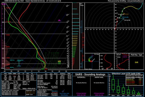
The skew-t / sounding posted above is the same HRRR model data. I’ve plucked this information from a point very near, and just to the south, to the strongest rotating storm. This may be tough to see, so I’ll blow up the most interesting part

Notice that close to the surface, that the temperature is slightly cooler than just above it. And that the wind is back from the northwest.
that would indicate that the storm was not surface-based, and was elevated. That would mean a lower tornado risk.
That said, plucking information just south of that point, you get this:

This is data that would indicate the chance for a surface-based storm with a potentially “strong” tornado.
So there is a very fine line that these storms may, or may not, be riding along. This is also, likely, why the CIPS was having such a difficult time during the days leading up to this event.
Regional severe weather climatology
The interesting crinkle to this whole setup is that the Gulf Coast doesn’t need higher numbers to produce significant severe weather.
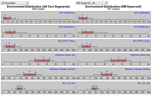
Notice that a lot of the tornadoes across sections of the region occur with Significant Tornado Parameter numbers below a 2. And Supercell Composite numbers below a 6.
For the more significant tornadoes, the window of opportunity of those numbers increase.
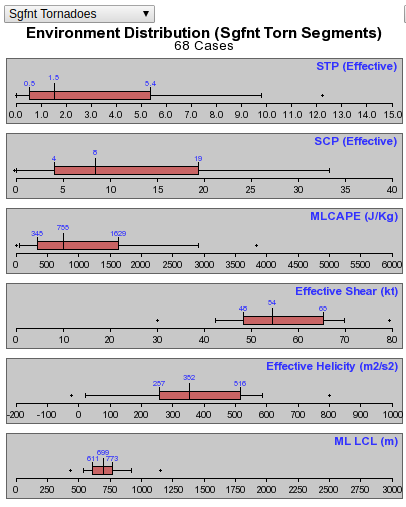
Note:
STP: 0.6 – 5.4
SCP: 4 – 19
But also notice that the average for STP is still around 1.5 and for SCP is around 6.
Today, across the region those numbers are ranging between 0.1 and 4.3 for STP and 1 and 16 for SCP.
CIPS Analogs
The CIPS Analogs are also showing there is a reasonably significant threat for a few severe storms.
This is interesting as CIPS has been waving back and forth between a significant risk and no risk during the last few days. And I think the reason is that this is a very “on the fence” setup where there needs to be a handful of events to occur in the atmosphere at the right place and at the right time to get severe weather going. And the computers are having difficult time projecting the outcome accurately.
Now that we are on the “day of” the event, the model data that CIPS uses has a better handle on the overall outcome and thus CIPS can offer a better estimation of the severe weather potential.
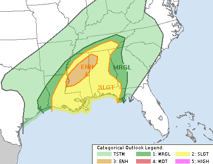
The Storm Prediction Center Discussion
Day 1 Convective Outlook
NWS Storm Prediction Center Norman OK
1019 AM CST Wed Feb 05 2020Valid 051630Z – 061200Z
…THERE IS AN ENHANCED RISK OF SEVERE THUNDERSTORMS OVER PORTIONS OF MISSISSIPPI AND NORTHWEST ALABAMA…
…SUMMARY…
Severe thunderstorms are expected today and tonight across portions of the lower Mississippi Valley and Southeast, with damaging wind gusts and a few tornadoes.…Lower MS into TN Valley…
Morning water vapor imagery shows a strong upper trough digging across the southern Plains. In the low-levels, a deepening surface low currently over LA will track northeastward along the front into parts of MS and northwest AL this afternoon and evening. The air mass in the warm-sector has become quite moist with dewpoints in the mid/upper 60s, with forecast soundings suggesting afternoon MLCAPE values around 1500 J/kg. Given the increasing forcing mechanisms, this should be sufficient for scattered thunderstorm development in vicinity of the low and front.12z CAM solutions suggest that convection will first form over central LA as the large-scale forcing approaches. Low-level
vertical shear will promote some risk of discrete supercells, along with more complex bowing structures. Forecast hodographs indicate favorable parameters for a few tornadoes, including the risk of strong tornadoes, as activity builds northeastward across the ENH risk area. Damaging wind gusts and perhaps some hail are also possible in the strongest cells.Later tonight, another round of severe storms appears likely to form along/ahead of the front across the remainder of the SLGT risk area. Models are more diverse regarding timing/placement of this activity, but sufficient vertical shear will pose a risk of a few supercells capable of damaging winds and isolated tornadoes.
The Karrie Meter
Here is a look at the regional Karrie Meter values for this evening.

Notice some of the higher values are across portions of southern Mississippi and then northern Alabama.
Bottom Line
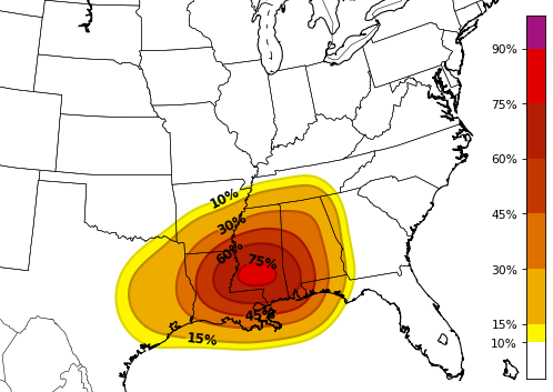
Severe weather will be possible across the Gulf Coast region today. The SPC has the area highlighted with a Slight Risk for most spots, and an Enhanced Risk for parts of northern Mississippi. There is a chance for heavy rain, frequent lightning, gusty wind, hail and the potential for a tornado or two – generally EF-0 or EF-1 for most spots. Ther eis the chance for an EF-2 or stronger tornado in the Enhanced Risk area.
The timeline for storms is between about 12p and 12a. That means this afternoon, this evening, tonight and into the overnight hours.
Please keep tabs on the weather, and stay tuned to local media outlets to make sure that you have quick access to the latest weather information.


