Happy Friday! As I laid out in my last post, this period coming up is going to be very wet, but that’s nothing new for you guys at this point. Looking at a rainfall estimate over the past 3 days, lots of the Northern Gulf Coast has received a lot of rain. Many areas, especially in our Louisiana parishes, have seen over 2” of rainfall.

Despite June being drier than average overall, the last week of June was nothing but wet. The Drought Monitor released yesterday still has us in abnormally dry conditions, but that may go away by the next update, at the current rate things are going at.
Unfortunately, for Sun lovers, plenty more is still possible and in the forecast. But if you’ve been hoping for rain, we’ve got more on the way.
We remain under a Marginal Risk of flash flooding, issued by the WPC, meaning that isolated flash flooding is possible with some of the more intense thunderstorms.
The ridge is going to be in a blocking pattern that will keep the remnants of Invest 95L in our area for a few more days, and it’s energy and rising air will help to spark some thunderstorms through the weekend. Eventually, the concentrated energy will dissipate, and the storm chances will drop accordingly.
In addition, this will lead to fewer clouds later on into next week. It’s been a lot more dreary than usual, but more sunshine is on the way!

Once 95L dissipates, the moisture is going to be stuck over our area, since the blocking pattern keeping the energy here will prevent any cooler or drier air from taking it’s place.
Taking another look at the PWAT, or a measure of water in the air, the expected values are going to be higher than normal. This map below doesn’t show the raw values, but how much more water there is in the atmosphere than normal. We’re seeing a lot of green, indicating that there will be more moisture in the air than we would expect for this time of the year.
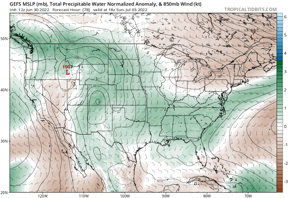
This type of moisture is spread out through the entire atmosphere, so it may not feel too much more humid than usual. This does mean that heavy rainfall is more likely, though, and that flooding will remain a threat for this next period.
It’ll feel hot and sticky, but nothing really unusual for the summer months.

Models are suggesting warmer temperatures than average, but once again, as far as how it feels outside, that isn’t likely to change too much.
Since I did last time, let’s take another look at the beach conditions across our area (places like Gulfport, Biloxi, Dauphin Island):
While there is a high rip current risk for areas like Miami and Palm Beach, FL, our beaches should have a low rip current risk for the next 3 days, according to the NWS Mobile.
Light winds and small waves should all combine to make a better couple of days for the beach compared to earlier in the week, but the lightning threat is still going to exist for the extended future, so please be safe, and stay away from the waters if a storm approaches.
Thanks to a lot of rain and storms, it really will be a pretty crummy week at the beach, but if you can take advantage of the drier conditions in the morning and it might not be too bad.
It looks like there may be ongoing thunderstorms during prime fireworks hours on July 4. If you can hold off for a while past sunset, the storms should dissipate relatively quickly. Hopefully they’ll be scattered enough to not impact the celebrations. Rain or shine, I hope everyone can enjoy the holiday and the time off work (if you have it!)
Day to Day Forecast
Today
Mostly cloudy, with a 70-percent chance of rain and thunderstorms. Highs in the mid-80s.
Tonight
Mostly cloudy, with a 30-percent chance of showers. Lows in the mid-70s.
Tomorrow
Mostly cloudy, with a 60-percent chance of afternoon thunderstorms. Highs in the upper-80s.
Tomorrow Night
Mostly cloudy. Lows in the mid-70s.
Sunday
Partly sunny, with a 50-percent chance of afternoon thunderstorms. Highs around 90F.
Sunday Night
Partly cloudy. Lows in the mid-70s.
Fourth of July
Partly sunny, with a 50-percent chance of afternoon thunderstorms. Highs around 90F. The heat index may reach 104F.
Monday Night
Mostly clear. Lows in the upper-70s.
Tuesday
Partly cloudy, with a 40-percent chance of afternoon thunderstorms. Highs in the low-90s. The heat index may reach 105F.
Tuesday Night
Partly cloudy. Lows in the upper-70s.
Wednesday
Partly cloudy, with a 50-percent chance of afternoon thunderstorms. Highs in the low-90s. The heat index may reach 107F.
Wednesday Night
Partly cloudy. Lows in the upper-70s.
Thursday
Mostly sunny, with a 40-percent chance of afternoon thunderstorms. Highs in the low-90s. The heat index may reach 105F.
Thursday Night
Mostly clear. Lows in the upper-70s.


