Summertime thunderstorms and heat in full swing: Southeast Weather Forecast – 7/21/22
Author: Gabriel Taylor
|| Published: 7/21/2022 at 11:31am
The Southeast is set to experience above-average temperatures and moist dewpoints over the next three days thanks to the subtropical ridge with a slight risk for severe thunderstorms in parts of NC, SC, GA, AL, and MS today. General pop-up thunderstorms are expected closer to the coasts on Friday and Saturday although precipitation coverage will be relatively low with most of the Southeast remaining dry.
Subtropical ridging will remain consistent over the South and Southeast for at least the next 3 days and has already warranted excessive heat warnings and advisories for much of the region. These warnings have been issued for the dangerously hot heat indices in excess of 110F from the strong diurnal heating and moist dewpoints. The only relief will be for those who are lucky enough to experience rain-cooled air from today’s thunderstorms and stray thunderstorms the next couple of days.
Severe Weather Outlook for Thursday, 7/21 // Courtesy: NWS Storm Prediction Center
The storm prediction center has issued slight and marginal risks for severe weather for a large portion of the Southeast today primarily for a damaging wind threat in any stronger storm clusters that develop in the afternoon/evening. Surface moisture and instability will be plentiful for thunderstorms to take advantage of; however, the main lifting mechanism for the storms won’t be very potent, causing thunderstorms to be fairly disorganized and sporadic in nature.
72-Hour Day 1-3 Total Rainfall (in.) // Courtesy: NWS Weather Prediction Center
The Southeast is expected to be the rainiest part of the country the next 3 days, with SC, GA, AL, and MS receiving most of the precipitation. By Friday and Saturday rainfall amounts will generally be low ranging from a tenth of an inch to half an inch from stray pop-up thunderstorms, which is not good news for the ongoing drought in the South and Southeast.
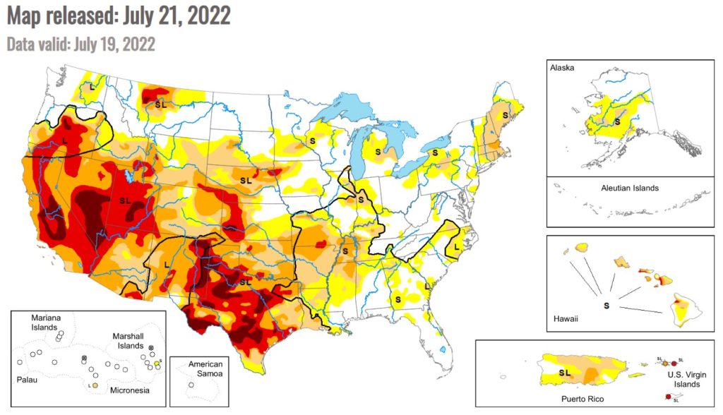
U.S. Drought Monitor // Courtesy: National Drought Mitigation Center
If you live in the South/Southeast and it seems dry (despite the uncomfortably high dew points) you’re not crazy! A large portion of the Southeast is experiencing abnormally dry conditions and plenty of land has reached the moderate and severe drought thresholds. Most of this drought is considered short-term (lasting less than 6 months) and should improve some with the rain today, but it will take more than that for conditions to fully improve.
3-Day Southeast City Forecasts
Dallas, TX
Thursday
Friday
Saturday
High: 98F
High: 101F
High: 101F
Low: 82F
Low: 82F
Low: 81F
Precip: 30%
Precip: 20%
Precip: None
Houston, TX
Thursday
Friday
Saturday
High: 98F
High: 96F
High: 96F
Low: 79F
Low: 80F
Low: 79F
Precip: None
Precip: 20%
Precip: 20%
New Orleans, LA
Thursday
Friday
Saturday
High: 92F
High: 92F
High: 91F
Low: 79F
Low: 79F
Low: 79F
Precip: 40%
Precip: 60%
Precip: 50%
Little Rock, AR
Thursday
Friday
Saturday
High: 100F
High: 102F
High: 100F
Low: 77F
Low: 78F
Low: 80F
Precip: 20%
Precip: None
Precip: None
Memphis, TN
Thursday
Friday
Saturday
High: 100F
High: 101F
High: 100F
Low: 76F
Low: 78F
Low: 80F
Precip: 20%
Precip: None
Precip: None
Birmingham, AL
Thursday
Friday
Saturday
High: 94F
High: 93F
High: 94F
Low: 74F
Low: 73F
Low: 74F
Precip: 60%
Precip: 40%
Precip: 20%
Atlanta, GA
Thursday
Friday
Saturday
High: 90F
High: 89F
High: 93F
Low: 72F
Low: 72F
Low: 74F
Precip: 80%
Precip: 40%
Precip: 30%
Author of the article:
Gabriel Taylor
Gabriel Taylor is an upcoming Junior studying Meteorology at Florida Institute of Technology. He enjoys forecasting and watching the weather whether it be in his hometown in New Jersey or at school in Florida.