The 2018-2019 Winter Outlook for the central sections of the northern Gulf Coast is done. And snow lovers aren’t going to be thrilled.
The Preamble
I know, I know. Everyone has one of these Winter Outlooks. And they all say something different.
Accuweather:

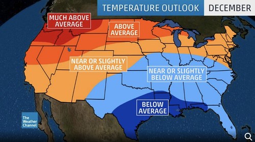
Weather Channel:
The NOAA Climate Prediction Center:

None of them give anything more than a broad brush of possible generalized conditions. What does “wet and chilly” even mean? And does EC mean there is as good of a chance that the area is warm AND cold?
The best question, though, is: How did these places even come up with these predictions?!?
They leave more questions than I have time to answer. Plus, I don’t even know how Accuweather or the Weather Channel come up with their forecasts since they are often proprietary secret formulas (like, say, TOR:CON) that no one else has access to see. The Climate Prediction Center explains their decision, somewhere, but I can’t track it down at this time.
The most frequent question asked of meteorologists is also the most important here: What about where I live?
This forecast is done specifically for southern Mississippi. However, if you live south of I-20 and between, say Lake Charles, Louisiana and Destin, Florida this forecast will likely apply to you, too.
The Forecast
Here is what our Winter Outlook looks like
Generally it looks like there is the best chance for “average” conditions to prevail north of I-20 this winter for both temperature and precipitation. And keep in mind that average means the typical temperature swings and the typical precipitation swings.
South of I-20, it looks like there will be a better chance for a warmer than average winter and a wetter than average winter. This will come with the typical temperature swings and precipitation swings, too. But the main difference will be that the cold snaps will be quicker to modify than normal and the days with precipitation may be a bit more numerous.
By Month vs. Average
November:
Starts cooler, ends warmer
Average Precipitation
December:
Starts warmer, ends cooler
Slightly above average precipitation
January:
Starts cooler, ends warmer
Average precipitation
February:
Starts warmer, ends warmer
Slightly above average precipitation
March:
Starts warmer, ends average
Above average precipitation
Specifics
While specifics aren’t really possible with seasonal outlooks like this, based on the analogous (similar) years, there are two takeaways…
1. There will be multiple rounds of low-end severe weather for the Gulf Coast. Similar setups to this year have provided the Gulf Coast with multiple rounds of severe weather with only one or two “outbreak” type events per year. That means that there may be – at times – a weekly threat for thunderstorms with damaging wind and EF0 and EF1 tornadoes.
2. Snow chances will be meager. Similar setups to this year have only provided one or two chances to see falling snow in this region. None have offered falling snow within 25 miles of the Coast itself. So if you like snow, you may have to drive north.
3. Each of the previous years with similar setups have offered at least one cold snap with highs around 40 and lows in – at least – the 20s. It looks like one or two shots of cold – mainly between mid-December and early January will be possible.
How’d we get here?
A great question. Considering both Accuweather and TWC are sugesting a colder winter. And the CPC is saying an equal chance for above and below average… Just how the heck did I get a “warmer” year then?
The process used looks at the forecast for El Nino in the coming months, the temperature difference between the Gulf of Alaska and Gulf of Mexico, the North Atlantic Oscillation forecast, the Pacific Decadal Forecast, and the three previous months climate records for a a handful of ASOS sites in the region. Blended together, the analogous years used were the winters of 1976-1977 (loose), 2006-2007 (strong), and 2014-2015 (marginal).
You may be thinking to yourself, “Wait just a second Mr. Weatherman! It snowed in Miami in 1977! If that year is similar to this year, what gives? How will we be warmer”
You’re right. Miami did see snow. And in 2006-2007, that winter was as flip-floppy as a fish out of water. Part of it was very cold, the other half was warm and wet. The 2014-2015 winter was warmer and wetter the whole way through.

But there is a common theme among the three. a developing El Nino. While there were a handful of – very, at times – cold shots into the Gulf Coast area, all three featured storm tracks that pulled in Gulf air more often due to the influence of a developing El Nino.
And with a Gulf that is running between one and three degrees above average in spots, that means more moisture and more heat that will be pulled north ahead of storm systems.
The North Atlantic Oscillation is going to dictate when and where the cold shots of air are going to occur. That is on a shorter time-scale than seasonal projections. That means there can still be cold shots of air, while the temperature for the season remains above average.
The Pacific Decadal Oscillation is a 20- to 40-year cycle. The connection to North American weather is complicated and not always linear as it has to do with many other factors, too. However, research at North Carolina State suggests that a warmer PDO means a cooler southeast with more precip.
The only reason this outlook disagrees with the PDO predicted “cooler” temperatures is our proximity to the above-average Gulf of Mexico. The PDO predictions are for an at-or-below-average Gulf. And, as discussed, that isn’t the case right now.
And based on the previous three months along the North Gulf Coast, minus the anomalous Hurricane, the area has been warmer than average with near-normal precipitation. This lines up, generally, with the analogous years selected. The only hiccup is the dry October in 2014 in the southeast, that doesn’t appear to be developing.
Bottom Line
Keep in mind that a prediction of a warmer and wetter winter does not mean that cold weather cannot happen. Nor does it mean that when cold weather happens, it is a surprise. It simply means that by the time it is all said and done, despite any abnormally cold periods, the overall months will end up warmer than average.


