Happy Sunday! The theme of the last few forecasts has been heat, and while that is still gonna stick around, it’s about time I get something new to talk about. This week looks to be one of the wetter ones this area has seen in a while!
Sunday brunch looks to be nice today, as skies are set to be partly cloudy this morning. There will be a chance of thunderstorms in the afternoon, though, so the best weather will be confined to the morning hours.
Once again, another Heat Advisory is in effect for a good chunk of the area. Heat indices up to 110 are currently in the forecast for most, but hopefully this will be the last day under an advisory for at least a couple of days.

Slightly cooler weather is on the way, with a cold front expected to move through the Southeast over the coming days. The front, and northerly winds, might help to scour out moisture and dry us out a little bit, especially tomorrow and Tuesday. The main front is going to pass through Northern MS today, and into our area by tomorrow. It probably is going to slow down or stop, and the really dry air is going to be stuck to the North.
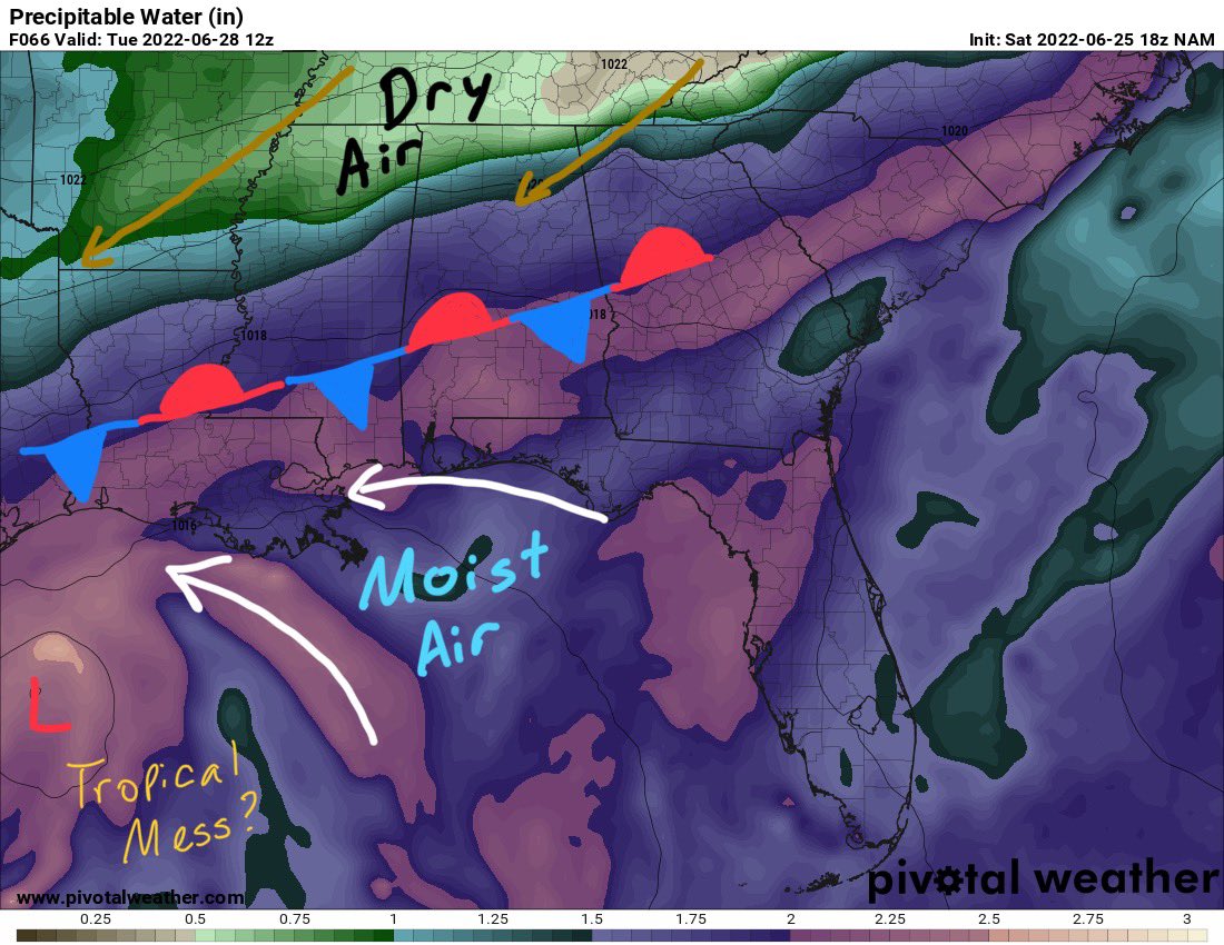
Below is a PWAT map, annotated with a front. If you could somehow turn all of the water vapor in the atmosphere into a liquid, the PWAT is roughly how much water you would have in your really tall rain gauge. Of course, this isn’t possible, but it shows a good estimation of the water vapor in the air. This time of the year, the average is about 1.6″, and 90-percent of the time, it’s below 2″. That purple region in South MS/AL represents 2″ of PWAT, meaning that there’s more water in the atmosphere than 90-percent of late June days.
Thunderstorms are expected to develop along the front tomorrow afternoon, and some could have heavy rain or gusty winds. Severe weather is not expected, however.
Speaking of heavy rain, one of the biggest stories this week is the rain chances. There is usually a portion of the summertime that features daily rain and storm chances. That is definitely going to be true for the upcoming week, as I’m highlighting storm chances every day. It might seem repetitive or lazy, but that’s what it looks like.
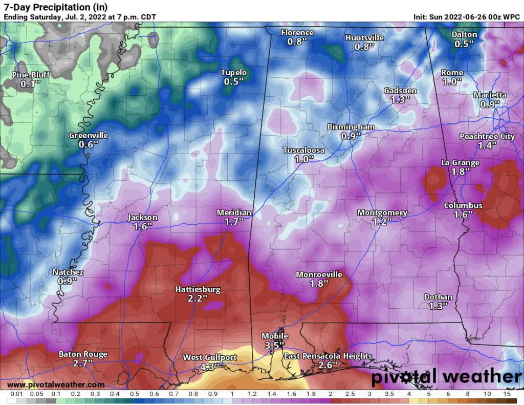
The Weather Prediction Center (on the right) issued their 7-day rainfall forecast, and it looks like a lot of the area is going to have their drought erased. Widespread 1-2” of rain is currently forecast through next Saturday night.
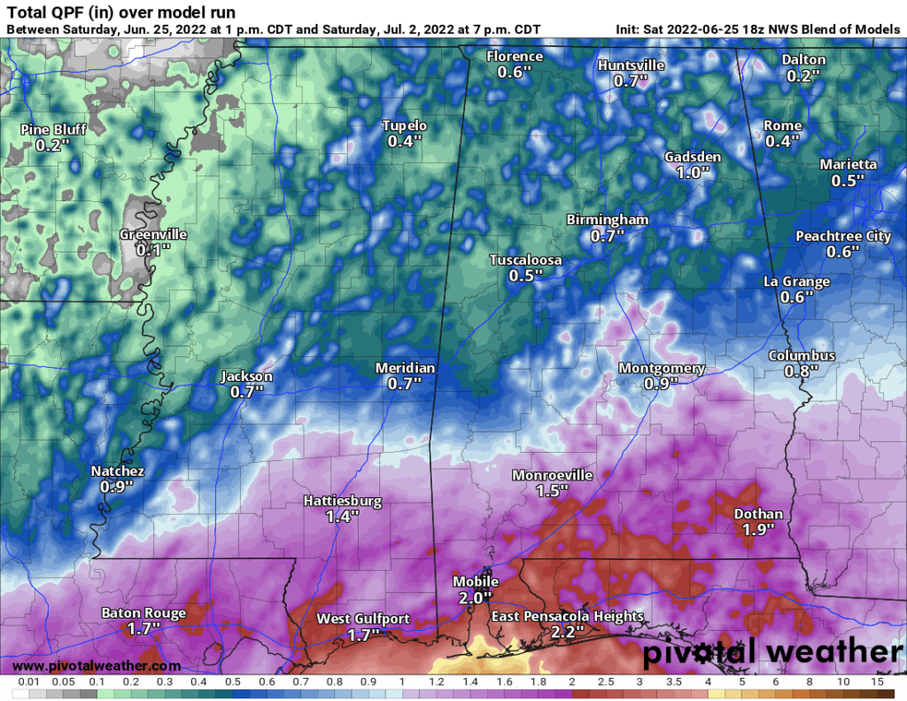
On the right, I have the National Weather Service blend of models rainfall estimates. Similarly, it shows a good amount of rain over the next week.
You’ll notice that both maps show heavier rainfall to the South. This is fairly typical, as the sea/land breeze interactions can spark more storms along the coast.
But, another potential reason for this is due to the front mentioned earlier-sort of.
As the front moves into the Gulf of Mexico, there is a chance that the convergence (causes rising air), as well as the vorticity (rotating wind), could spin up a weak tropical disturbance in the Gulf of Mexico early this week. If this happens, which the NHC thinks is a low possibility (20-percent), then it’s most likely to form in the Tuesday-Wednesday timeframe.
This potential storm will not directly affect Mississippi or Alabama, as it looks to more directly impact the Texas coastline, but it could bring some adverse impacts here regardless. I will go into more detail on this morning’s tropical weather update.
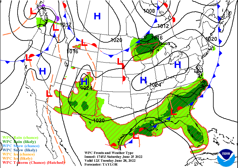
Generally speaking, this storm will bring an increase of moisture in the area, and even if it stays far away, the increase in moisture plus the stalled out front leads to enhanced rainfall over the area. Below is the WPC front predictions from Tuesday-Saturday, and you can see the cold front stop in it’s tracks and dump rain day after day.
The ridge is going to stay strong over the Southeast. There are some fluctuations, but as is typical during the summer, we will stay under the influence of this blocking high pressure. This is why the potential tropical storm is going to drift Westward, and potentially impact the Texas coast, but it’s also why Invest 94L is set to stay away from the Gulf Coast, which is a welcome sign.
As Nick says, the heat and humidity is a small price to pay for keeping away tropical systems.
With daily rain chances during the afternoon, the heat is probably going to be a lot more bearable this week. Today is the only day this week that currently looks to have dangerous heat indices. Talk about great news!
Those are all the big players for the next week, so let’s get into the forecast!
Day to Day Forecast
Today
Partly cloudy, with a 60-percent chance of afternoon thunderstorms. Highs in the mid-90s. The heat index may reach 108F.
Tonight
Mostly cloudy, with a 30-percent chance of showers, ending before midnight. Lows in the mid-70s.
Tomorrow
Partly sunny, with a 70-percent chance of afternoon thunderstorms. Highs in the low 90s.
Tomorrow Night
Mostly cloudy, with a 40-percent chance of rain, ending before midnight. Lows in the low-70s.
Tuesday
Partly sunny, with a 50-percent chance of afternoon thunderstorms, with better chances South of US 84. Highs in the low-90s.
Tuesday Night
Mostly cloudy. Lows in the low-70s.
Wednesday
Mostly cloudy, with a 40-percent chance of scattered thunderstorms. Highs in the low-90s.
Wednesday Night
Mostly cloudy, with a 40-percent chance of rain showers. Lows in the low-70s.
Thursday
Mostly cloudy, with a 70-percent chance of rain and thunderstorms. Highs in the upper-80s.
Thursday Night
Mostly cloudy, with a 40-percent chance of rain. Lows in the low-70s.
Friday
Mostly cloudy, with a 60-percent chance of rain and thunderstorms. Highs around 90F.
Friday Night
Mostly cloudy, with a 20-percent chance of lingering showers. Lows in the low-70s.
Saturday
Partly sunny, with a 60-percent chance of afternoon thunderstorms. Highs in the low-90s.
Saturday Night
Mostly cloudy. Lows in the mid-70s.


