Surface map from 1/28/19 00z NAM // Courtesy: Pivotal Weather via GIPHY
Sounds like an episode of the 1960s Batman TV show doesn’t it? I have good news, it will be just as fun.

As we head through Monday and night and through the morning on Tuesday, a cold front will sweep through the area bringing a chance for some precipitation and some much colder temperatures.
Because both the precip and the cold will overlap for a short period of time, there will be a chance for some wintry precipitation across parts of the South that don’t usually see it. In this case, South Mississippi.
But what makes this cold from different than the last cold front? Both had precipitation. Both had colder air. Why does is overlap this time? And not last time? And how much and what type of wintry precipitation are we talking about here?
All great questions. I hope to answer most of them. With science.
Why doesn’t the Gulf Coast see snow?
You didn’t ask this, but understanding why is an important first step toward understanding why there is a chance for it now. Because the Gulf Coast can get temperatures around freezing. In fact, it can get below freezing at the surface and there can be precipitation falling, but the area usually doesn’t see snow.
Generally that is because cold fronts at the surface are usually faster than the cold air aloft.
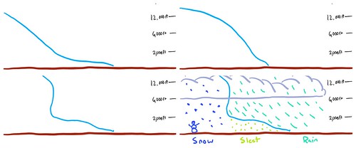
Take these graphics (Sure there are prettier graphics out there to explain this, but I don’t like stealing other people’s work. I’d rather made a rough sketch.) above, for example, they showcase how the area ends up with sleet and freezing rain. Generally our atmosphere has a warm patch about 2,000 to 6,000 feet off the ground. This is due to our proximity to the Gulf of Mexico.
Even when super strong cold fronts come barreling toward the Gulf, usually (1) the trajectory of the front (the direction it is coming from) tends to allow the warmer air aloft to hang around and (2) where the forcing / vertical motion are occuring will not line up where it needs to be, to give the area any snow. Instead the area gets sleet instead.
What makes this time different?
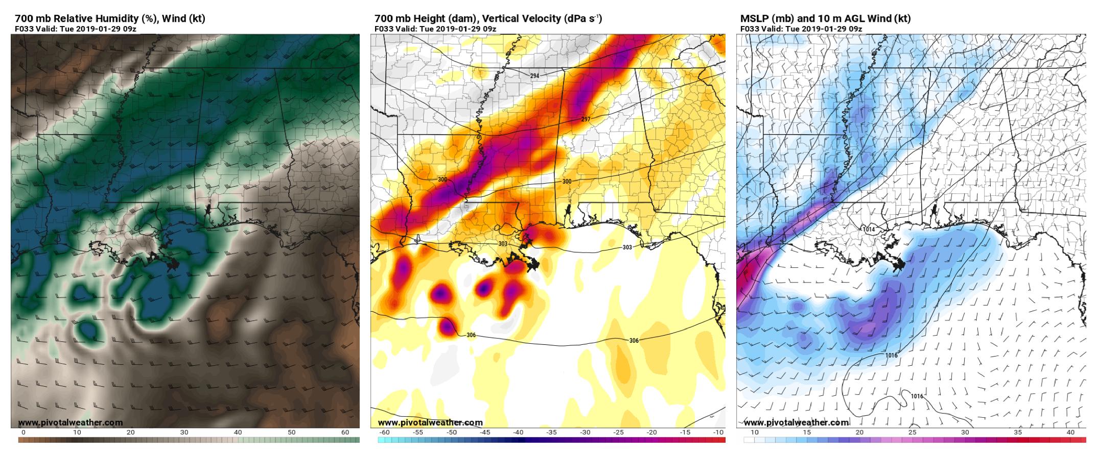
A few things are different. In this case, the trajectory of the front isn’t as north-south and has more of an east-west orientation. Looking at the graphic below, the wind-shift on the far right image shows the front runs from, roughly, McComb to Meridian. Generally, fronts are a bit more north-south and run from McComb to, say, Tupelo. That difference allows the cold air to burrow south without inviting the warmer air in the lower-and-middle layers of the atmosphere to stay put.
Also, this time the vertical motion of the air along the front, the area where precipitation is forming, is actually behind the surface cold front, and not along it.
Generally, when the area has a chance for rain or thunderstorms, the cold front at the surface is – almost – right under where the vertical motion in the mid-levels is. This is because the air being pushed around at the surface is moved upward, through all the different altitudes of the atmosphere, usually within an updraft of a storm. Another way to think of it is the updraft the air gets into is a physical consequence of a cold front pushing warm air upward. And the updraft usually happens because the air is warm and humid and is reasonably buoyant compared to the cold and dry air behind the cold front.
700mb versital velocity from 1/28/19 00z NAM // Courtesy: Pivotal Weather via GIPHY
In this case, the front is out ahead of where there is vertical motion in the mid-levels. That means there is going to be an area that is colder at the surface under an area that is also colder aloft.
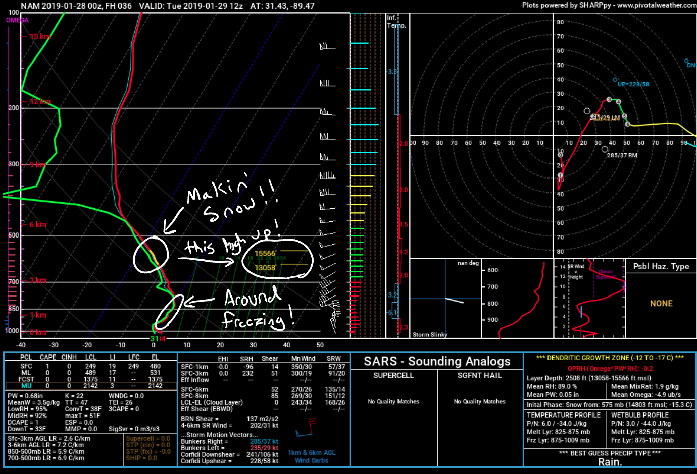
Take a look at the Skew-T above. Notice that the data shows that the atmosphere will be making snowflakes in the Dendritic Growth Zone! And the DGZ is up between about 13,000ft and 15,000ft. Also notice that between about 1,000ft and 4,000ft the temperature – according to the NAM model – will be around freezing. That means that any snowflakes that are being made can fall down to the surface with very little – if any – melting.
Want to learn more about readona Skew-T chart? Check this out!
The other thing to take a peek at on there is the “Omega” on the left hand side. Those are the pink little lines poking out from the left-hand side of the Skew-T. Omega can be very important when it comes to building snowflakes. Without getting into the weeds too far, Omega is a good measure of how much “warmer and moist” air is being moved into that particular area of the atmosphere. Warmer and moist are in quotes because this is a relative term. “warm” in comparison to -20F may not be “warm” at all. And “moist” compared to a dewpoint of -20F may not be “moist” at all.
Skew-T data from 1/28/19 00z NAM-3KM // Courtesy: Pivotal Weather via GIPHY
The idea is, if you move “warmer and moister (not a real word) air” into a place that is colder and drier… but is building snowflakes, you can build more snowflakes!
And if this is done over-and-over-and-over-and-over again, that is how you end up with a lot of snow.
In the case of this particular cold front, the model data doesn’t show evidence for a long-duration snowfall event. Because the cold dry air comes sweeping in – at every level of the atmosphere – very quickly.
So how much of what type of precipitation will I see, Nick
Depends on where you area. The further north you are, the more snow you’ll have a chance to see. The further south you are the fewer flakes will fall. Truly figuring out how much snow will fall is hard enough. But then figuring out how much will stick around? Whew!

There are a few other hurdles to get over, particularly in the south, when predicting snowfall accumulations: Ground temperature, snowfall rate, and change-over timing.
Each one of those parameters can not individually determine how much snow will accumulate. Instead it is the combination of the three that will dictate how much snow accumulates. And that is tough.
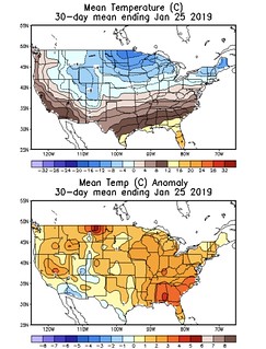
Generally ground temperatures in the South are well-above freezing. The Climate Prediction Center data shows the Gulf Coast region and the South with soil temperatures averaged over the last 30 days between 50 and 60 degrees. And given the warm weather this weekend and anticipated on Monday, soil temperatures will likely still be running between 50 and 60 degrees. That is about five degrees above average.
So any snow that falls onto the ground will have to cool the ground down from 50 or 60 degrees to 32 degrees. That will take time. Or a lot of effort. In this case more “effort” would be a higher snowfall rate. The snowfall rate will be dictated by a lot of things. One is that Omega parameter I was showing above. A “down and dirty” way of figuring out if higher snowfall rates will be possible is… Yhe more Omega, the more likely there will be higher snowfall rates. Now that can’t tell you how fast snow will fall and really there needs to be more vertical motion, forcing, etc, etc, etc. But a quick way of figuring it out is Omega.
In this case, it looks like there will be enough vertical motion and Omega to promote a short time period – up to an hour or two – where snowfall rates will be high enough to help cool the ground down and promote snowfall accumulations.
That brings us to change-over timing. Because if the snowfall rate is highest when, say, rain is falling and not snow… That completely changes the whole game!
Along this front, it looks like the change-over will occur, depending on location, about two hours after the front passes.
Surface wind speed & direction from the 1/27/19 18z NAM // Courtesy: Pivotal Weather via GIPHY
That means there will likely be two hours of a cold rain falling onto a 50- to 60-degree ground (cooling that ground to whatever temperature the rain is) before the rain changes over to snow. Then, after the rain changes to snow, that snow will have to continue to fall to cool the ground down below 32 degrees in order for the snow to start to stick.
Then, after the snow starts to stick, the question becomes just how long will it be snowing after that point in order to accumulate snow on the ground.
As an aside, this just another reason why I loathe those snowfall maps showing XX” of snow 5 or 10 days out. They can’t be right. There are so many variables. So. Many.
Alright, Nick I read through all of your science stuff… Can I have a forecast now?
Sure thing!
Looks like the best chance for accumulating snow will be across our northern counties. Still possible everywhere, but your best bet will be farther north. pic.twitter.com/64PzXwQERr
— Nick Lilja (@NickLilja) January 27, 2019
Not much has changed from this morning in terms of forecast accumulations. If you live in South Mississippi you’ll end up between ‘snow in the air and nothing on the ground’ and ‘snow in the air and 1.5″ on the ground’ by the time it is all said and done. A few places may get a bit more, others may only get a rain/snow mix and never full change over.
No matter what happens with the weather, it is likely to cause travel problems, school schedule changes, and cause some businesses to experience staffing issues. Prepare for it to be cold, too.
Thankfully this will be a short burst. Things get back to normal Wednesday.
Today’s Severe Risk

Today’s Tornado Risk

Search the Site
Categories
- Archive
- Climate
- Coastal MS/AL/LA
- Education
- Environment
- Forecasting
- Geology
- High Plains Weather
- Midwest Weather
- Northeast Weather
- Northwest Weather
- Not Weather
- Research
- River Flooding
- Seasonal Outlooks
- Severe Weather Discussions
- Site Updates
- South Plains Weather
- Southeast Mississippi / Southwest Alabama
- Southeast Weather
- Southwest Mississippi
- Space
- Storm Chasing
- Tropics
- Weather & Sports
- Weather & TV
- Weather History
- West Coast Weather
Topics
2019 Atlantic Hurricane Season 2020 Atlantic hurricane Season Alabama Weather Amarillo weather Archives cold cold front CONUS Weather Coronavirus COVID-19 COVID19 Drought Flooding Forecasting freezing rain Gulf Coast Weather hail Heat Hurricane hurricanes Kansas Agriculture Kansas Weather Louisiana Weather Mississippi Weather NHC pine belt weather rain Severe Thunderstorms Severe Weather snow Southeast weather south Mississippi weather SPC Texas Weather Thunderstorms Tornadoes Tropical Storm Tropical Weather tropics weather weather forecasting weekend forecast weekly outlook Wind Winter Weather


