As a decent cold front pushes south through the area rain will start early Tuesday morning. Then, as the morning progresses, it will mix with sleet and snow. Finally after late morning and toward lunch, it will turn to all snow before ending shortly after lunch.
Latest data suggests accumulations will be between nothing and about an inch and a half. But I’m not sold on estimated totals yet. Still a bit early in the game for that.
But enough of that quick-and-easy and not-detailed-enough forecast stuff. Let’s have some fun!
Nerd Alert!
The front that is set to cascade this direction during the morning on Tuesday continues to have a more meridianal line as newer and more high-resolution data comes in.
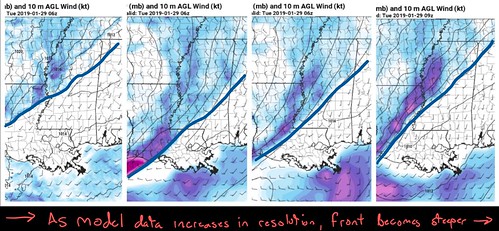
The timing is also a bit slower, too.
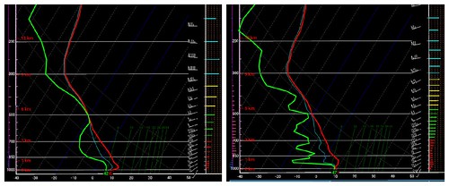
REMINDER: Global models have a lower resolution for the data they import and export. that means there is some information that is, inherently, missing in comparison to shorter-range, regional higher-resolution models. That missing data is very, very important for forecasts for snow
This may have some pretty big consequences as far as the forecast is concerned. This is also why – despite the requests for it – I don’t pull the trigger on saying “it is going to snow!” until about 72 hours out. This is also why I rarely offer snow total estimates more than 48 hours out, too.
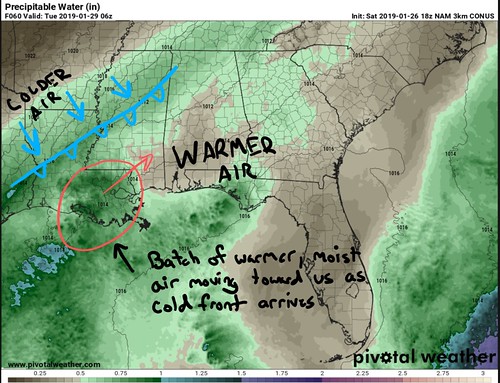
So what does that change mean? The change could mean more of a push in southern Mississippi of warmer, more moist air, at the surface, ahead of the front itself.
With a warmer, more moist air mass in place, when the front does move through the area there will be more moisture to squeeze out of the atmosphere as the front passes. This could increase the rain totals across the area before the change-over occurs.
More rain means more moisture in the soils, on the pavement, in the trees, etc. More moisture in and stuck to everything means it may take extra time for those things to cool down to below freezing. The longer that takes, the less time any falling snow will have to “stick” before melting.
That also means that with the same exact amount of “snow” falling out of the sky, there is a chance that the total accumulation will be lower. Because some of it will melt, not “stick” to the ground.
The higher resolution data, the NAM, also shows the air as much drier swinging in behind the front. That drier air would put the lid on snowfall quicker. That would also reduce snowfall accumulation totals.
That is why for now, the forecast is for nothing to about 1.5″ of snow.
What are the chances we get more?
Medium. There is enough dry air in the mid-levels that evaporative cooling could lower the temperature in that region of the atmosphere to below freezing as the front passes. That means that snowflakes would make it closer to the ground sooner, but would likely still melt above the surface for a few hours.
But, if enough snowflakes were being built and snowing down hard enough, it could cool the atmosphere down with it, pushing snow all the way tot he surface sooner.
Snow at the surface sooner means higher snow accumulation totals.
Plus, there is a chance that enough moisture is stuck in the Dendritic Growth Zone to build snowflakes behind the front for a few hours. The snow at that point would be reasonably light, but it would be snowing. So while it might not add much to the snow totals, it would look neat for a while.
What are the chances we get less?
Less than nothing? That would be tough to do. But the chances that snow has a chance to fall but never stick is, for you snow lovers, depressingly high.
If this meridianal theme continues in the modeling, it may mean that we get extra rain on the front end, and less snow sticking around after a change-over occurs. In fact, there is some indication that Tuesday morning parts of the area could get into the 50s with rain falling. 50-degree rain water on the ground is going to take a lot longer to cool back to freezing than, say, 39-degree water.
It may also mean a higher chance that roads ice over Tuesday night and into Wednesday as the left-over water on the roads freezes as the colder air swings into the area.
Information overload, dude… Just tell me what is going to happen
Right, for some of you, I know you just want to know what will happen. I get that. As of now, this is what we are thinking, but it is likely going to change a bit in the coming days due to all of the things I just covered…
We are currently watching as a decent cold front pushes south through the area on Tuesday morning, really early – likely before sunrise. Rain will start early Tuesday morning. Then, as the morning progresses, it will mix with sleet and snow. Finally after late morning and toward lunch, it will turn to all snow before ending shortly after lunch.
Latest data suggests accumulations will be between nothing and about an inch and a half. But I’m not sold on estimated totals yet. Still a bit early in the game for that.
The Take Home…
Truly, the end result of snow accumulation may be moot. The most likely thing I can forecast is that traveling will be difficult all day Tuesday. Whether you are driving early, in the dark, in the cold rain. Or if it is later in the morning while the roads are just wet with snow falling. Or if you are driving late Tuesday night, when the roads may have black ice.
If you have plans to travel on Tuesday, it may be time to make a back-up plan in case the roads are too slick to travel. Also, if you plan to travel have a winter weather kit in your car. Water, blankets, sand, an ice scraper, and some gloves.
Schools will, probably, cancel classes on Tuesday as a precaution. I can’t forecast what schools will actually do. But I can tell you that your kids’ safety is their top priority. And seeing the chance for icy roads by mid-morning, most schools will likely opt just to cancel classes all together.
People will likely be acting odd – both driving and in the stores and out running errands. We all know what snow does to people. For whatever reason some people starting acting up. I bet there is a run on the local grocery stores for supplies, even though this is going to be a one-day event. Even though by Wednesday it will be 45 to 50 degrees and mostly sunny.
Lastly, and I think I’ve said this a few times but, the forecast is going to change. It should change drastically, but the timing may change, the precipitation type may change, etc. Be prepared to keep up with the forecast tomorrow and Monday.


