This may be a pretty lengthy and detailed write up, so feel free to skim it for the parts you want. Or read the whole thing and be super informed!
As the long-awaited Kelvin Wave pushes across the Tropical Atlantic, things are reasonably active with three areas of interest and one more wave on deck.
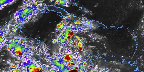
The list goes… Invest 97L, Invest 98L / Tropical Depression 13, and soon-to-be Invest 99L, and the next wave behind it. The Top 2 things worth noting are Invest 97L and TD13. Here is a look at how they have evolved during the past 24 hours.
A tale of two invests: #97L and #98L over the past 24 hours.
The 8pm EDT NHC outlook gives 97L (left) a 70% chance of formation and 98L (right) a 90% chance of formation in the next 48 hours. pic.twitter.com/AG32nQUE3D
— 😷 Kim Wood (@DrKimWood) August 20, 2020
A big thanks to Kim Wood up at Mississippi State for those cool graphics.
Tropical Depression 13
Tropical Depression 13 was designated on Wednesday night by the National Hurricane Center for their 10pm Advisory.
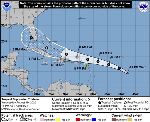
SUMMARY OF 1100 PM AST…0300 UTC…INFORMATION
———————————————–
LOCATION…14.6N 47.9W
ABOUT 1035 MI…1670 KM ESE OF THE NORTHERN LEEWARD ISLANDS
MAXIMUM SUSTAINED WINDS…35 MPH…55 KM/H
PRESENT MOVEMENT…WNW OR 295 DEGREES AT 20 MPH…31 KM/H
MINIMUM CENTRAL PRESSURE…1008 MB…29.77 INCHES
OFFICIAL NHC DISCUSSION
The low pressure system that NHC has been monitoring over the central tropical Atlantic has now developed a well-defined center of
circulation and maintained enough organized deep convection to be classified as a tropical depression, the thirteenth cyclone of the
2020 Atlantic hurricane season. The depression already has some banding features on its north and west sides as evident in
geostationary satellite and microwave images. The initial intensity is set at 30 kt based on ASCAT data from around 0100 UTC and a
T2.0/30 kt Dvorak classifications from TAFB.
The depression has been moving fairly quickly to the west-northwest, with the latest initial motion estimated to be 295/17 kt. It should be noted that the initial motion is somewhat uncertain given that the system has only recently formed. A subtropical ridge currently over the central Atlantic is expected to build westward during the next several days and should be the primary steering feature for the depression through the forecast period. This pattern should keep the depression on a fairly quick west-northwest track during the next several days, taking the cyclone near the northern Leeward Islands by Friday night and near the Greater Antilles and southeastern Bahamas this weekend. The models are in fairly good agreement, but there is some north-south spread with the GFS being on the southern side of the guidance envelope and the ECMWF on the northern end. The NHC track forecast lies down the middle of the guidance suite.
The environmental conditions appear generally favorable for the depression to strengthen, with the wind shear expected to remain relatively low while the system moves over warm SSTs and remains in a moist airmass. These conditions should promote gradual strengthening and it seems quite likely that the cyclone will be a tropical storm when it moves near or north of the northern Leeward Islands in a couple of days. The bigger question is how much interaction will there be with the Greater Antilles. If the depression moves on the south side of the guidance envelope, further strengthening would be limited due to land interaction. Conversely, if the system gains more latitude and moves north of these highly topographic islands, it could have the opportunity for more significant intensification. The NHC intensity forecast, which is of low confidence, is roughly near the middle of the guidance
envelope.
KEY MESSAGES
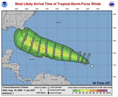
1. Tropical storm conditions are possible across portions of the northern Leeward Islands by Friday night, and Tropical Storm Watches have been issued for some of these islands. Heavy rainfall is likely across this area beginning late Friday.
2. There is a risk of tropical storm conditions in the Virgin Islands and Puerto Rico Friday night and Saturday and Tropical Storm Watches could be required for these islands tomorrow. Interests there should closely monitor the progress of this system.
3. The details of the long-range track and intensity forecasts are more uncertain than usual since the system could move over portions of the Greater Antilles this weekend. However, this system could bring some rainfall and wind impacts to portions of Hispaniola, Cuba, the Bahamas, and Florida this weekend and early next week. Interests there should monitor this system’s progress and updates to the forecast over the next few days.
FORECAST POSITIONS AND MAX WINDS
INIT 20/0300Z 14.6N 47.9W 30 KT 35 MPH
12H 20/1200Z 16.1N 50.8W 30 KT 35 MPH
24H 21/0000Z 17.4N 54.6W 35 KT 40 MPH
36H 21/1200Z 18.4N 58.4W 40 KT 45 MPH
48H 22/0000Z 19.1N 62.1W 45 KT 50 MPH
60H 22/1200Z 19.9N 65.9W 50 KT 60 MPH
72H 23/0000Z 20.8N 69.7W 55 KT 65 MPH
96H 24/0000Z 22.9N 76.7W 60 KT 70 MPH
120H 25/0000Z 26.2N 82.2W 60 KT 70 MPH
Invest 97L
Even though Invest 97L looks a bit disorganized on the infrared imagery, the thought is that it will become better organized int eh coming days.
The National Hurricane Center gives it a 70- to 80-percent chance of development during the next two to five days. That means it could be a Tropical Depression in as little as 48 hours.
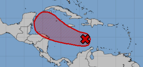
The forecast from the NHC takes Invest 97L near to the Central American coast by this weekend. Beyond that model data takes this system to the north and toward the Gulf.
So far there is some disagreement between the model data about how far north it turns. There is still a chance it flops over the Yucatan and into the Bay of Campeche. But there is also a decent shot it glides north and into the central Gulf.
This creates an interesting scenario where there may be – for the first time that I’m aware of – areas that could be in the Forecast Cone from the NHC for two different storms simultaneously.
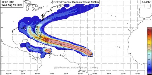
Model Data for TD13 & Invest 97L
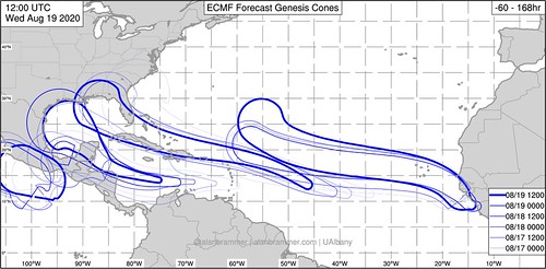
This “simultaneous Double Cone” is shown on the EPS model data from Alan Brammer at University of Albany. You can see there is some overlap on there. The forecast data from the 12z run of the EPS on 8/19/20 shows that Monday and Tuesday would be the day where that would occur – if it occurs.
The GEFS is showing an interesting situation on the data from the 12z run on 8/19/20 where it has two “hot spots” splitting Florida. A good number of the models take it into the Gulf and another number of them keep it in the Atlantic.
The model data doesn’t suggest – at this point – two Major Hurricanes.


That said, intensity forecasts are the most difficult forecasts to get right. Especially when looking out more than 72 hours. So please take these forecasts for what they are at this point, just an estimation.
There are a few hurdles that both of these systems have to jump over before more organization and any intensification can occur.
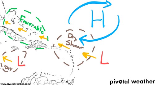
Big thanks to the Pivotal Weather guys for (indirectly) offering “blank” maps of the tropics. The above map shows the Big Picture in the Atlantic through the next few days. A big ridge of high pressure with both guide TD 13 and offer a brief bit a shearing to it during the next 72 hours. Tropical Depression 13 will move through an area with drier air and a bit of shear as it approaches the Leeward Islands and Puerto Rico, then later move toward a more favorable environment as it approaches the Bahamas.
This may lead to a weaker Tropical Storm (Laura?) for the Puerto Rico and the potential for significant intensification as it approaches Florida.
Further south…
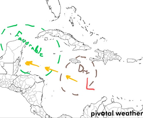
Invest 97L is working through some dry air right now, but will move into a more favorable environment as we get closer to the weekend. The question becomes how close to land will it be? The current model data shows it slowing down, and perhaps even stopping, as it approaches Central America before turning to the north.
Ready to go down a rabbit hole of Catch 22 ‘weatherdom’? What will dictate how fast and how much the storm turns north will be how much it develops. And what will dictate how much it develops will be how much it slows down. And what will dictate how much it slows down will be its interaction with the upper level flow.
And what will dictate that? To some extent… how fast and how much it develops. This is why forecasting these tropical systems can be a bit of a bear to tackle at times.
The next wave
It’s like the DJ Khaled took over the weather…
Yes there is another wave – actually two – behind Invest 97L and Tropical Depression 13.

This one has a 10- to 40-percent chance for development during the next two to five days. Truly, probably an even better chance once you look out to about seven days. This one will – likely – be mostly a ‘fish storm’ that should stay out to sea. But it will need to be monitored over the next five days to see how quickly it develops and when it starts to make the turn to the north.
Who needs to prepare, and when, for what?
I made a helpful guide for which areas need to keep tabs on these systems for potential impacts:

These areas need to be prepared for the potential for a tropical system to impact the are between Sunday night through Wednesday morning. Usually with one system we can block off certain areas and say, ‘well it isn’t as likely’ but with two systems in play, every section of the Gulf and southeast coast is in place with these systems.
As with all landfalling tropical systems the main concerns are heavy rain, flooding, wind, and storm surge.
So, to quickly reiterate: Sometime between Sunday night and Wednesday morning one – or both – of these systems may make it into the Gulf of Mexico and impact areas along the coast and inland.
Timeline
Right now it looks like the Gulf Coast won’t need to worry about these systems arriving until – at the earliest – Monday of next week. So you have plenty of time to prepare.
How should I prepare now, Nick?
Double check your Hurricane Preparedness Kit. Make sure you have enough food, water and medicines in there to last up to a week. And since we are also tackling this situation during a pandemic, make sure you have extra cleaning and sanitizing supplies. Double check that you have a mask for each person, too.
If you aren’t certain what belongs in a Hurricane Preparedness Kit or how to prepare for a landfalling tropical system, check this out.
The Bottom Line
There is still a lot we don’t know at this point. The Hurricane Hunters haven’t even flown through these systems yet. So until we can get some better model data and these systems get a little better organized, we won’t have all of the answers.
Hang in there. Keep tabs on the forecast. And check back here for update every morning.


