The tropics continue to ramp up as Invest 97L has now organized itself enough to be designated a Tropical Depression. Just 12 hours ago Invest 98L did the same thing.
The thought it that both will become tropical storms by Friday night. One Laura. The other Marco.
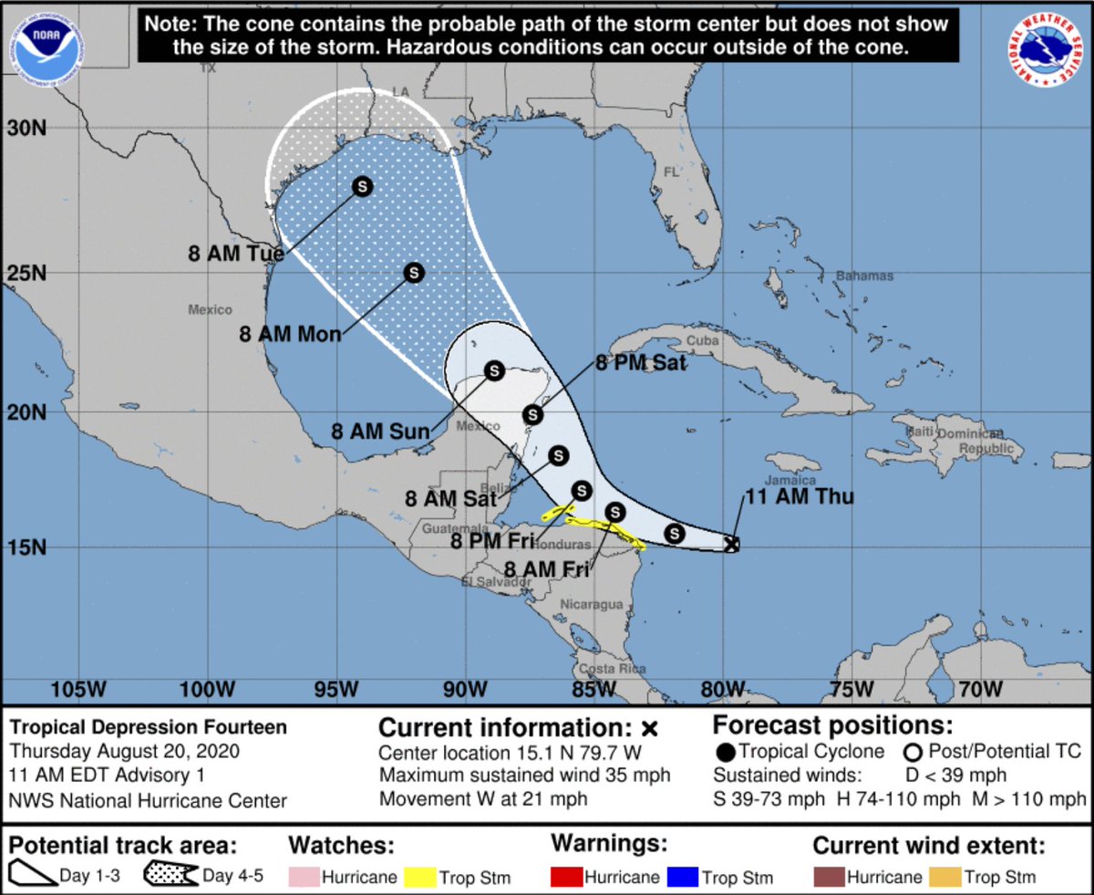
Newly-minted Tropical Depression 14
Here is the latest on Tropical Depression 14:
SUMMARY OF 1100 AM EDT…1500 UTC…INFORMATION
———————————————–
LOCATION…15.1N 79.7W
ABOUT 235 MI…375 KM E OF CABO GRACIAS A DIOS ON NIC/HON BORDER
MAXIMUM SUSTAINED WINDS…35 MPH…55 KM/H
PRESENT MOVEMENT…W OR 280 DEGREES AT 21 MPH…33 KM/H
MINIMUM CENTRAL PRESSURE…1007 MB…29.74 INCHES
FORECAST POSITIONS AND MAX WINDS
INIT 20/1500Z 15.1N 79.7W 30 KT 35 MPH
12H 21/0000Z 15.5N 81.9W 35 KT 40 MPH
24H 21/1200Z 16.3N 84.2W 40 KT 45 MPH
36H 22/0000Z 17.1N 85.5W 50 KT 60 MPH
48H 22/1200Z 18.4N 86.4W 55 KT 65 MPH
60H 23/0000Z 19.9N 87.4W 60 KT 70 MPH
72H 23/1200Z 21.5N 88.9W 45 KT 50 MPH
96H 24/1200Z 25.0N 92.0W 50 KT 60 MPH
120H 25/1200Z 28.0N 94.0W 50 KT 60 MPH
DISCUSSION
Visible satellite images indicate that the area of disturbed weather moving across the central Caribbean Sea has developed a
closed surface circulation, with the center embedded beneath cellular convective cells and a large cirrus canopy. Also,
convection has increased in organization, and TAFB and SAB have given the system classification of T2.0/30 kt and T1.5/25 kt,
respectively. Therefore, advisories are being initiated on Tropical Depression Fourteen with maximum winds of 30 kt. An
expected ASCAT pass later today and an Air Force Reserve Hurricane Hunter mission scheduled for this afternoon should give us a better
handle on both the depression’s center location and its maximum winds.
The depression continues to move westward at a pretty good clip, currently estimated to be on a heading of 280 degrees at 18 kt. This motion is being driven by the western extent of the Bermuda high, which currently noses into the northwestern Caribbean Sea. However, a deep-layer trough over the Gulf of Mexico is expected to become the main driver in the coming days, causing the cyclone to slow down and turn rather suddenly toward the west-northwest and northwest in the next 24-36 hours. A general northwestward motion should then continue until the end of the 5-day forecast period, bringing the system across the Yucatan Peninsula Saturday night and into the central and western Gulf of Mexico early next week. Most of the reliable track models are clustered close to one another, and the official NHC track forecast is therefore very close to the multi-model consensus aids, including the HCCA model.
Once the depression slows down during the next 24-36 hours, environmental conditions appear ideal for strengthening. The magnitude of vertical shear is expected to be less than 10 kt for at least the next 2 days, while the system will be moving over the deep, warm waters of the northwestern Caribbean Sea, where sea surface temperatures are 29-30 degrees Celsius. Given these conditions, some of the intensity guidance actually appears more muted than I would have expected, and I have therefore elected to closely follow the SHIPS and LGEM models, which are near the upper end of the guidance envelope. It is possible that the depression could be near or at hurricane strength when it approaches the Yucatan Peninsula of Mexico in 2-3 days. Some weakening is
anticipated when the center moves over land, and then re-strengthening is likely after it moves over the Gulf of Mexico. There will be an increase in shear over the Gulf in 4-5 days, and right now there is greater-than-normal uncertainty in how this will affect the cyclone’s intensity at that point. For now, the official forecast on days 4 and 5 shows a flat-lined intensity, and this scenario lies a little above the ICON intensity consensus and
the HCCA model solution.
KEY MESSAGES
1. Tropical Depression Fourteen is expected to strengthen over the northwestern Caribbean Sea through Saturday, and it could produce tropical-storm-force winds and heavy rainfall over portions of the coast of Honduras and the Bay Islands beginning tonight through Friday. The system could be near or at hurricane strength when it reaches the Yucatan Peninsula of Mexico late Saturday, and watches could be required for a portion of that area later today.
2. The system is expected to move into the south-central Gulf of Mexico as a tropical storm on Sunday. Some strengthening is anticipated while it moves northwestward over the western Gulf of Mexico early next week, but it is too soon to know exactly how strong it will get or the location and magnitude of impacts it will produce along the central or northwestern Gulf Coast. Interests in that area should continue monitoring the progress of this system over the next few days.
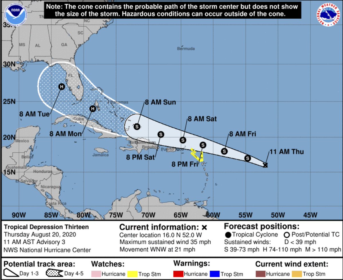
Tropical Depression 13
Here is the latest on Tropical Depression 13:
SUMMARY OF 1100 AM AST…1500 UTC…INFORMATION
———————————————–
LOCATION…16.0N 52.0W
ABOUT 750 MI…1205 KM E OF THE NORTHERN LEEWARD ISLANDS
MAXIMUM SUSTAINED WINDS…35 MPH…55 KM/H
PRESENT MOVEMENT…WNW OR 290 DEGREES AT 21 MPH…33 KM/H
MINIMUM CENTRAL PRESSURE…1008 MB…29.77 INCHES
FORECAST POSITIONS AND MAX WINDS
INIT 20/1500Z 16.0N 52.0W 30 KT 35 MPH
12H 21/0000Z 17.0N 54.7W 35 KT 40 MPH
24H 21/1200Z 18.0N 58.3W 40 KT 45 MPH
36H 22/0000Z 18.9N 61.6W 45 KT 50 MPH
48H 22/1200Z 19.6N 64.7W 50 KT 60 MPH
60H 23/0000Z 20.4N 68.1W 55 KT 65 MPH
72H 23/1200Z 21.5N 71.8W 60 KT 70 MPH
96H 24/1200Z 24.0N 78.6W 65 KT 75 MPH
120H 25/1200Z 27.0N 83.4W 65 KT 75 MPH
DISCUSSION
The organization of the depression has not changed much overnight or this morning. An area of convection has persisted near the estimated center, with some banding noted over the northwestern portion of the circulation. An earlier SSMIS overpass was very helpful in locating the center of what appears to be a small circulation. A very recent ASCAT overpass has also revealed a small circulation that is weak on the southeastern side, but with winds near tropical storm strength to the north of the center. The ASCAT data along with subjective Dvorak classification from TAFB and SAB support maintaining the 30-kt initial intensity.
The depression continues to move briskly west-northwestward or 290/18 kt. The track forecast philosophy has not changed from before. A subtropical ridge over the central Atlantic is forecast to build westward and strengthen over the next several days. This pattern is expected to keep the cyclone on a west-northwestward heading throughout the forecast period. The dynamical models continue to agree on this overall scenario, but there some differences in both forward speed and how close it gets to the Greater Antilles. In general, the models that indicate a stronger cyclone favor a more northern track, while those which depicted a weaker system are along the southern and faster side of the envelope. The latest consensus aids are little north of the previous track, and the new NHC forecast lies between the HFIP corrected consensus and the TVCA multi-model consensus. This is slightly north of the previous advisory, and not far from the GFS ensemble mean.
The environment consisting of light to moderate vertical wind shear is expected to allow for gradual strengthening over the next few days, and the NHC forecast calls for the system to become a tropical storm later today or tonight. The upper-level wind pattern is expected to remain favorable in the latter portion of the forecast period, and if there is minimal land interaction, a faster rate of strengthening is possible at that time. The NHC intensity forecast now shows the system becoming a hurricane by 96 hours, but it is a little lower than the consensus aids at days 4 and 5 due to uncertainty in how much the system will interact with the Greater
Antilles.
KEY MESSAGES
1. Tropical storm conditions are possible across portions of the northern Leeward Islands by Friday night, and Tropical Storm Watches have been issued for some of these islands. Heavy rainfall is likely across this area beginning late Friday.
2. There is a risk of tropical storm conditions in the Virgin Islands and Puerto Rico Friday night and Saturday and Tropical Storm Watches could be required for these islands later today. Interests there should closely monitor the progress of this system.
3. The details of the long-range track and intensity forecasts are more uncertain than usual since the system could move over portions of the Greater Antilles this weekend. However, this system could bring some storm surge, rainfall and wind impacts to portions of Hispaniola, Cuba, the Bahamas, and Florida this weekend and early next week. Interests there should monitor this system’s progress and updates to the forecast over the next few days.
The Bottom Line
Given the new forecasts from the NHC, I’ve updated my – rather crude, but hopefully effective – Map of Concern:

Based on the Forecast Cone from the NHC, Texas and Florida need to be putting their Hurricane Plans into effect now. Double-checking supplies, preparing their homes, etc. Same goes in Cuba and the Yucatan. Others along the Gulf Coast can wait, cautiously, to see if the forecast shifts.
The central Gulf Coast is living the Stealers Wheel life.
We are Stuck in the Middle of two tropical systems.
The forecast intensity for both of these systems is in the “low confidence” range. That means there is still a lot of uncertainty about just how strong these are going to get. And when. So it is important to take steps now to prepare for a tropical system if you are int he path of either of these systems.
And when preparing, the NWS always recommends that you prepare for one category higher than what is forecast to affect your area.
Can they merge to form a Super Hurricane?
No. That isn’t really how that works. How does it work? Well a few years back we did a quick science experiment on TV. Take a look:
Interesting Note
When was the last time two tropical storms were in the Gulf at the same time? It has been a while according to Philip Klotzbach:
The only two occasions where Atlantic TCs were both at least of tropical storm strength using IBTrACS Gulf of Mexico definition that I could find are: September 5, 1933 (Treasure Coast and Cuba-Brownsville) and June 18, 1959 (Unnamed and Beulah).
— Philip Klotzbach (@philklotzbach) August 19, 2020


