There are two tropical systems in the Eastern Pacific, Erick and Flossie. Both pose a wave threat to the Hawaiian Islands. One, Flossie, has a higher potential for actually skirting the Big Island bringing rain and wind.
Erick

The model guidance on Erick is to take it just south of the Big Island. And models continue to trend farther southward, too.
The National Hurricane Center notes this:
Tropical Storm Erick Discussion Number 8
NWS National Hurricane Center Miami FL EP062019
1100 PM HST Sun Jul 28 2019The storm’s cloud pattern is becoming better organized and has taken on a comma shape, with very cold cloud tops to at least -80 deg C. There is prominent upper-tropospheric outflow, except over the northeastern quadrant of the circulation. An eye is not yet evident in the imagery, however. Erick’s current intensity estimate is set at 60 kt in general agreement with objective Dvorak estimates from UW-CIMSS. The dynamical guidance indicates that the vertical shear will remain below 10 kt for the next 48 hours and SSTs should remain near 28 deg C, which would favor steady strengthening. Additionally, the SHIPS Rapid Intensification Index continues to show a high probability, near 70 percent, of rapid strengthening. Thus the official wind speed forecast shows a significant increase during the next 1 to 2 days, with the system predicted to attain major hurricane status within that time frame. This is in agreement with the corrected consensus, HCCA, and the FSU Superensemble guidance, FSSE, along with the HWRF model simulation.
Erick continues to move westward, or around 270/14 kt. A mid-level ridge is predicted to remain to the north of the tropical cyclone over the next several days which should maintain a mainly westward track. The track models suggest a slight bend toward the west-northwest in 36-72 hours, but with no substantial northward excursions. The new official track forecast is quite similar to the previous one, and is a little south of the latest dynamical model consensus. It should be noted that the latest ECMWF model run shows a track that is even a little farther to the south.
The wind radii have been adjusted based on data from a recent ASCAT-C overpass which depicted a slightly larger storm than previously estimated.
FORECAST POSITIONS AND MAX WINDS
INIT 29/0900Z 11.7N 134.5W 60 KT 70 MPH
12H 29/1800Z 12.2N 136.7W 70 KT 80 MPH
24H 30/0600Z 12.8N 139.7W 85 KT 100 MPH
36H 30/1800Z 13.5N 142.3W 95 KT 110 MPH
48H 31/0600Z 14.1N 144.6W 100 KT 115 MPH
72H 01/0600Z 15.3N 148.9W 85 KT 100 MPH
96H 02/0600Z 16.0N 153.5W 60 KT 70 MPH
120H 03/0600Z 16.9N 158.2W 40 KT 45 MPH
Here is a look at the computer model guidance:


Notice that the track lines are very close together. That means there is pretty good agreement between the model data that the track is going to stay south. It also means there is higher confidence that, even with some slight changes in the overall weather pattern, the track should hold.
As far as intensity, I try not to look at those graphs more than about 72 hours (3 days) out. Notice that the now-Tropical Storm is set to peak in intensity in about 60 hours, on Wednesday night.
Flossie
Flossie may be the more ‘interesting’ of the two storms for the Hawaiian Islands. This one is forecast to undergo rapid intensification in the coming days.

The official Five-Day forecast from the National Hurricane Center doesn’t look out far enough to see Flossie getting close to the Hawaiian Islands. However, model guidance does show this as a possibility – and between the two storms, a better possibility.
The NHC discussion:
Tropical Storm Flossie Discussion Number 4
NWS National Hurricane Center Miami FL EP072019
1100 PM HST Sun Jul 28 2019Over the past several hours, deep convection has developed near the center of circulation with a large curved band composed of cloud tops as cold as -80 C enveloping the western semicircle of the cyclone. A recent ASCAT-C scatterometer pass partially captured the northeastern quadrant of the system and measured winds of 30 kt over 75 n mi from the center and it is likely that higher winds were occurring at that time in the unsampled area closer to the center. In addition, the mean of the subjective Dvorak satellite intensity estimates have increased to tropical storm force and therefore the depression has been upgraded to Tropical Storm Flossie with an initial intensity of 35 kt.
The initial motion is 275/17 kt. Ridging will persist north of the cyclone throughout the next several days which will continue to steer it west to west-northwestward with some decrease in forward speed by later today as the ridge weakens slightly. The track guidance is in very good agreement and the official NHC forecast track is similar to the previous forecast which is very near the center of the consensus aids.
The environment around Flossie is favorable for strengthening over the next 72 hours or so, and if the current deep convection can persist near the center today during the diurnal minimum, then the inner core of the cyclone will likely become well established over the next 24 hours. This would allow for steady strengthening to occur, with Flossie becoming a hurricane sometime on Tuesday. Although not implicitly shown in the forecast, it is possible that Flossie could undergo rapid intensification during the next 72 hours which could result in intensities higher than currently forecast at those time frames. By day 4, the cyclone is forecast to move over marginal sea surface temperatures and into a drier, more stable environment while undergoing increasing northwesterly shear. This should result in a weakening trend beginning around hour 96 of the forecast period. The official NHC intensity forecast was changed little from the previous forecast, and remains on the higher end of the intensity guidance.
FORECAST POSITIONS AND MAX WINDS
INIT 29/0900Z 12.5N 113.0W 35 KT 40 MPH
12H 29/1800Z 12.7N 115.6W 45 KT 50 MPH
24H 30/0600Z 12.6N 118.5W 55 KT 65 MPH
36H 30/1800Z 12.8N 121.1W 65 KT 75 MPH
48H 31/0600Z 13.3N 123.7W 75 KT 85 MPH
72H 01/0600Z 14.5N 128.9W 95 KT 110 MPH
96H 02/0600Z 15.8N 134.5W 95 KT 110 MPH
120H 03/0600Z 17.5N 140.5W 90 KT 105 MPH
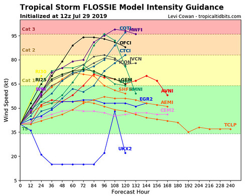
Model guidance shows a steady climb in intensification through the next 72 hours.
The sea-surface temperatures during the next 72-108 hours will be plenty warm for strengthening to, and sustaining, Major Hurricane status. The question is about environment. But given that Erick is traversing the same basic path and strengthening, there is high confidence that Flossie will also strengthen.
Track guidance shows that it is ‘walking down the same street’ in a manner of speaking as Erick.

One asterisks I’ll add to forecast track is this…

The big ridge of high pressure to the north of Flossie (and Erick) is going to do a good job at steering both storms out to sea and toward the Hawaiian Islands. The storms will bounce along the outer periphery of the ridge until they find a weakness and can head north toward the north pole (that’s just what these storms like to do because of physics). Right now the one ridge is close enough to a second ridge further west-northwest that Erick will bounce around the first ridge, and then bounce around the second ridge, staying south of the Islands.
Flossie may have a few points to jog north sooner.

Notice on the above map I’ve highlighted some ‘bumpers’ on there. These bumpers don’t really exist but are used to highlight there there will be weakness in the ridge for Flossie to drift further north.

As Flossie strengthens, due to Coriolis, it will tend to try to move north toward the pole sooner. This is also shown in the track guidance image a few images above. The TABD model shows the track for Flossie if it is a stronger storm than the other models. Notice that the track line for the TABD moves further north than other models.
If Flossie strengthens quickly and bounces further north at the first X, it will have a better chance of getting closer to the Big Island.
The second X is where it may eventually start to turn north, and that would mean it could scrape across some of the other Islands as well. Or, there may be a weakness that allows Flossie to slide north of the islands altogether.

However, by that time, the waters will be much cooler and the environment will be less conducive for sustaining a Tropical System – of any strength – at all.
That is why Flossie will need to be monitored closely.


