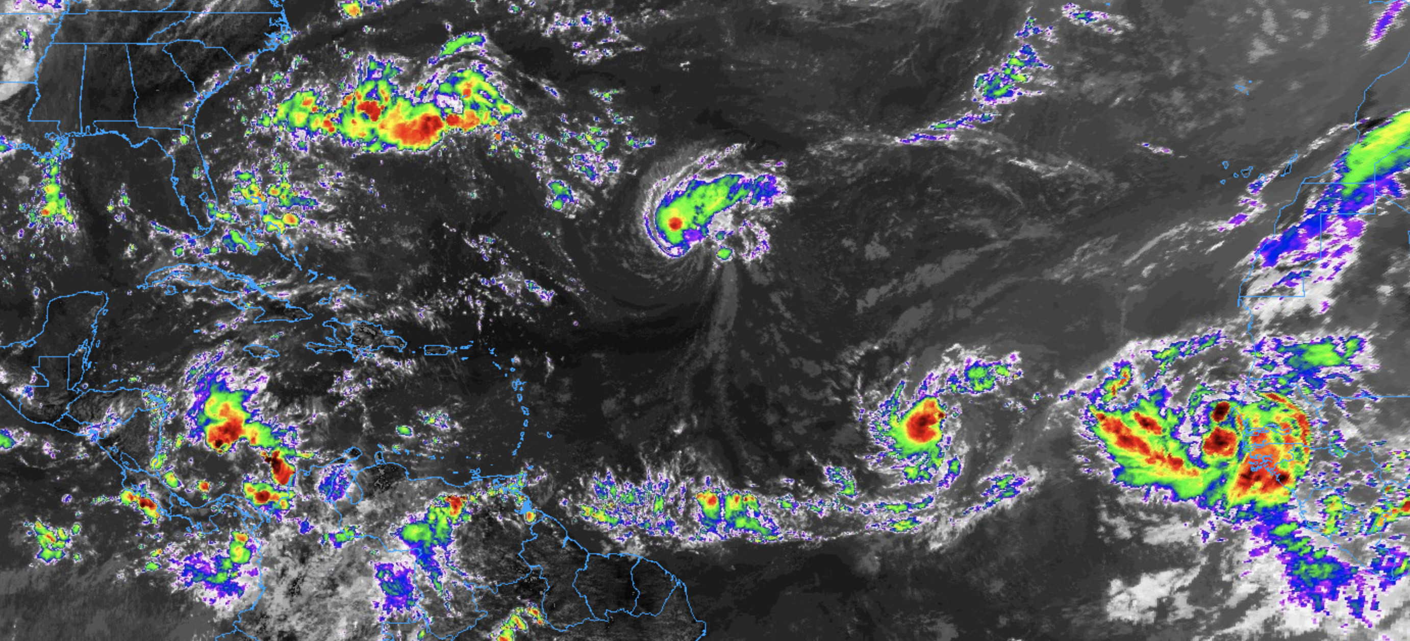
Things are heating up in the tropics right in time for the peak of the Atlantic Hurricane Season. There is Tropical Storm (as of this writing) Florence in the open Atlanct headed toward Bermuda, Potential Tropical Cyclone Eight just off the coast of Africa set to move across the Cabo Verde islands, and Invest 92L – the little invest that could – that is drifting toward the Greater and Lesser Antilles.
Let’s talk about each individual area of interest…
Florence
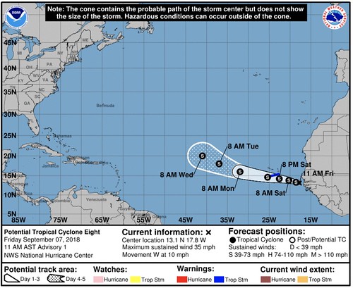
Unlike Florence Joyner, this Florence is in no hurry. Here is the 11AM advisory on September 7th from the National Hurricane Center:
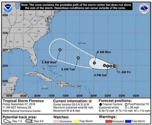
Florence continues to keep forecasters – and people live along the east coast – on their toes. The models haven’t done bad with Florence, the problem is that the models can only do so much. Forcasters want to alert people to danger as soon as possible. And the models simply don’t allow us to do that with Florence more than about five days out.
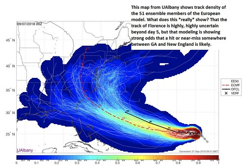
In fact, take a look at this model data, pulled from Space City Weather’s Matt Lanza, showing the broad range of outcomes the models have depicted beyond five days out.
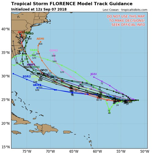
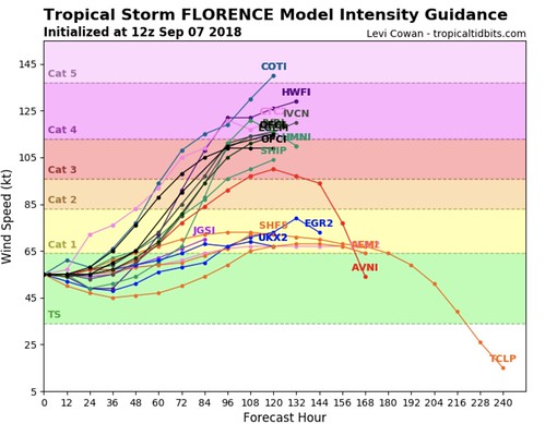
That’s not all, either. That is just one suite of models. here are some others from Tropical Tidbits…
Intensity forecasts aren’t always great, but the thought is that Florence will re-intensify.
That is why the National Hurricane Center uses the forecast cone. Hurricanes are difficult to nail down, and it is best to use an average area rather than a specific point.
At this point, if you know anyone who lives between Charleston, SC and Boston, MA – you may want encourage them to keep an eye on the forecast. And double check their Hurricane Preparedness Kit. But that’s about all, for now.
I’m guessing some national new organizations will say “People on the east coast from Florida to Main are on high alert for Florence!” tonight or in the coming days. But this isn’t the time to feel anxious or get anxiety about this storm. Now is the time to double check your Kits and simply watch for new updates.
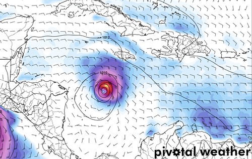
Potential Tropical Cyclone Eight
This one shouldn’t be a problem for the United States. But could give the Cabo Verde Islands a rough ride during the next few days. Here is the latest fromt eh National Hurricane Center:
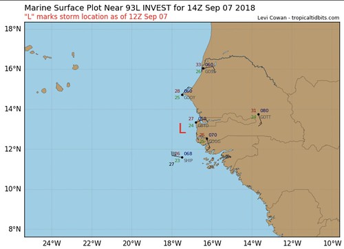
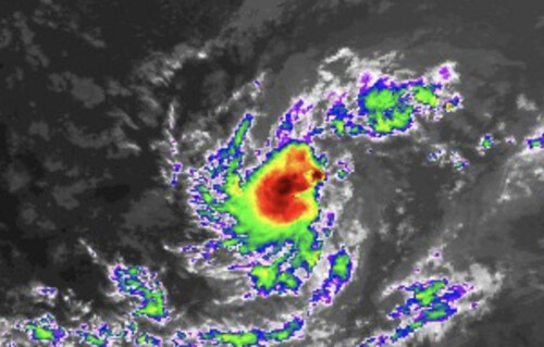
A closer look at where it is located currently from Tropical Tidbits…
This storm is anticipated to stay out to sea once it passes the Cabo Verde Islands.
As it passes the Cabo Verde Islands it is forecast to be a Tropical Storm.
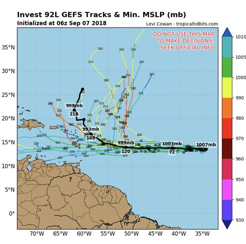
Invest 92L
This is the one that has my attention. This storm has the highest chance of impacting the Gulf Coast of the three. And even, at this point, that threat is low. But it does seem to have some of the symptoms of a storm that we will need to keep a close eye on over the next few days.
Invest 92L is having a tough time getting organized, which isn’t great for the Gulf Coast. This may sound counter-intuitive, but the faster this thing gets organized and wraps up into a Tropical Storm and Hurricane – the better.
No, I don’t want a big hurricane to come here. But ‘physics is our phriend” here. Because of Coriolis Force, as storms strengthen, they are – generally – more attracted toward the North Pole. So the faster Invest 92L gets stronger, the faster it wants to turn north and stays out to sea. The longer this thing stays unorganized the longer it will continue drifting west toward the Caribbean – and potentially the Gulf.
The only asterisk in there is that is also depends on the atmospheric setup around the storm. Tehre are a lot of different thigns that go into a storms track. For example, sometimes there is nothing in the way, so it zips north. Other times, different areas of high pressure get in the way. So it can be a strong system and still move west (Remember Irma last year?).
This is one reason forecasting tropical system tracks beyond five days gets tough.
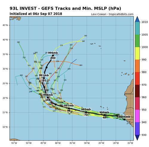
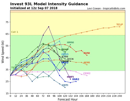
So what do the computer models say? Great question!
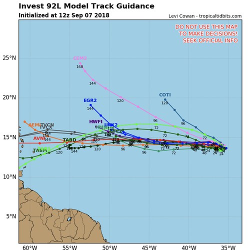
Most of the models in the spaghetti plots – including the TABD model which is run based on the storm strengthening to a hurricane – keep it moving west toward the Caribbean. And the TABD isn’t the only model that thinks Invest 92L will strengthen. Seven of the 15 models in the model intensity graph from Tropical Tidbits has Invest 92L as “Hurricane Isaac” by next Wednesday.
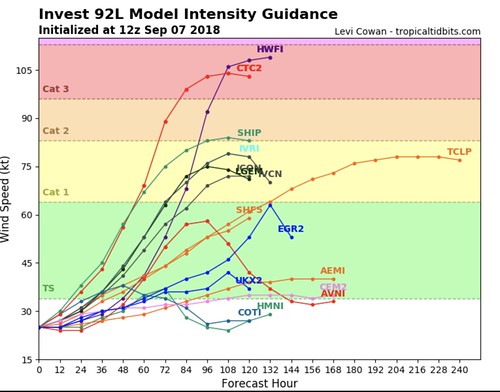
The other eight keep it as Tropical Storm Isaac.
Either way, though, based on the spaghetti plots, it would seem to suggest it will continue to drift west. The good news? The GEFS Ensemble data that looks beyond five to seven days suggests the storm turns north eventually.
But, a lot like Harvey last year, that turn doesn’t always happen. Especially if the system is very disorganized.
For now, there is far too much uncertainty to say what will or won’t happen with this storm. But this is the early heads up that we are watching it. And some evidence to explain why I’m watching it the closest out of the three storms that are out there.
The Bottom Line
Don’t worry about any of these storms messing with your weekend in South Mississippi. In fact, these storms won’t even impact your weather during the next work week, either! These are all quite a ways out. But I know there is a lot of scary stuff floating around the internet and it is tough to know what to believe.
For now, just double-check your hurricane preparedness kit and watch the weather for updates!


