The National Hurricane Center is now monitoring two areas of interest in the Atlantic Ocean. A new Potential Tropical Cyclone is off the coast of Africa and the other is a wave near the Caribbean.
What you need to know in South Mississippi
There is no immediate threat to the area. and it is still too far out to know for sure what – if any – impacts there will be to our area from one (or both) of these tropical disturbances.
That said, the Potential Tropical Cyclone off the coast of Africa is very unlikely to bother the area. It is most likely to turn north long before it threatens the area.
From the NHC
Tropical Weather Outlook
NWS National Hurricane Center Miami FL
200 PM EDT Thu Aug 30 2018
For the North Atlantic…Caribbean Sea and the Gulf of Mexico:
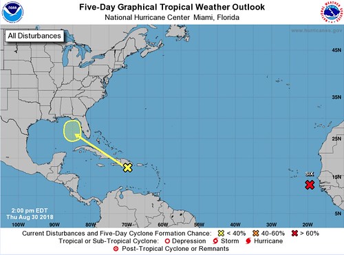
1. The National Hurricane Center is issuing advisories on Potential Tropical Cyclone Six, located southeast of the Cabo Verde Islands.
* Formation chance through 48 hours…high…80 percent.
* Formation chance through 5 days…high…90 percent.
2. A tropical wave (the yellow X in the top image) located over the north-central Caribbean Sea is producing a large area of cloudiness and thunderstorms extending from Hispaniola northeastward across the northeastern Caribbean Sea and adjacent Atlantic waters. This activity is forecast to spread westward to west-northwestward, but strong upper-level winds are expected to prevent any significant development of this system during the next several days. Environmental conditions could become more conducive when the system reaches the eastern Gulf of Mexico early next week. Regardless of development, this system could produce enhanced rainfall across portions of Hispaniola, the Bahamas, the Turks and Caicos, and Florida into early next week.
* Formation chance through 48 hours…low…near 0 percent.
* Formation chance through 5 days…low…10 percent.
The take home info
Keep an eye on the forecast. But don’t change any plans at this time.


