It must be late August or early September. The love bugs are out. The humidity isn’t quick as dense. And there are four – count ’em! – areas worth watching in the Tropics.
Oh, and the models are hinting at a cold front passing all the way down to the Gulf. Busy in the weather world, like usual, this time of year. You may recall my “free pass” to everyone last week. Well, I hope you used it!
I wanted to be wrong… pic.twitter.com/xudMbRs7F5
— Nick Lilja (@NickLilja) August 31, 2020
The reason is, because of all five things on the plate, the cold front is probably the least likely to cross paths with South Mississippi.
… To the Tropics!
The Invests
There are now two “Invests” in the tropical Atlantic. One is close to the mainland of the US and the other is in the Caribbean. So far, neither looks to be any imminent threat to the States.
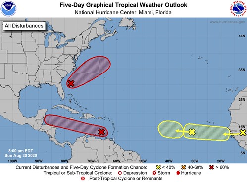
Invest 90L
The National Hurricane Center is keeping tabs on an area of low pressure trying to develop and move off the shore of the East Coast. The NHC notes that the satellite and radar shows the area a couple of hundred miles east of Jacksonville, Florida. This would be moving away from land. The NHC says that environmental conditions may become more conducive for some development by the middle of the week. The NHC gives the area a 60-percent chance of development between now and Tuesday and a 70-percent chance of development by week’s end.
Invest 99L

Invest 99L looks to be more of a problem for the Caribbean and Central America than anywhere else. The National Hurricane Center is monitoring showers and thunderstorms sliding into the eastern Caribbean that continue to shows some signs of organization. Right now, the tropical wave (Invest 99L) is a bit more broad but environmental conditions are expected to gradually become more conducive for development as Invest 99L makes it closer to the central and western Caribbean. The NHC notes that people in Jamaica, Honduras, Belize, Guatemala and the Yucatan peninsula should continue to check back for updates on this system.
The NHC gives it a 70-percent chance of development during the next 48 hours and an 80-percent chance during the next five days.
It is worth noting that there is a ridge of high pressure currently keeping things out of the Gulf of Mexico. But that ridge is forecast to lift northeast later this week. So depending on teh track and strength of Invest 99L, it may be more worthy of our attention later in the week.
Two waves coming off Africa

Both of these, while ‘on our radar’ are not any immediate threat to develop. The current thinking is that the environment around these system is just not conducive for development during the next few days. Things may change by the end of the week, but for now, there is a ‘wait and see’ mentality with these two waves.
The NHC gives these waves a 30-percent, or lower, chance for development during the next two-to-five days.
Beyond that…
There looks to be a brief period – around September 7th – when a tropical wave will slide out into the open Atlantic from Africa and have a decent chance at getting better organized. This is reflected in both the American and European models. And is worth noting and monitoring in the future.
The Cold Front
First off, sadly, don’t get your hopes up. The chances of a cold front passage in early September is historically very low. However, there is the chance that one get a bit closer than average and increases the chance for rain and helps keep temperatures down a bit from September 9th through the 12th. It will be short-lived and may not be very much cooling… but it is better than nothing, I suppose.
The Climate Prediction Center has even highlighted the chance for a cool down in their latest forecast.
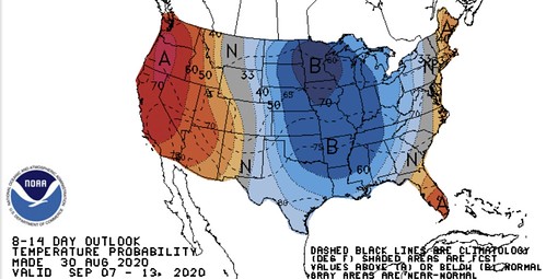
I would estimate, though, that the extent of the cool down southward will be trimmed in the coming days and shifted further east.


