Today across the southern Texas panhandle and across parts of west Texas there will be elevated to critical fire weather dangers. Please exercise extreme caution in these areas today.
Elevated to critical fire weather dangers are realized when:
• Afternoon temperatures are greater than 10F above average (“ridging” at 850mb is also a player)
• Wind speeds are in excess of 15mph
• Afternoon relative humidity levels are below 15-percent (especially when overnight relative humidity levels did not peak above 40-percent
For today, given the set up ahead of a north-to-south moving cold front, the biggest concern is for a slice of land between Amarillo, TExas and Lubbock, Texas.
Take a look at the following:


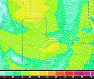
Notice that the area between Amarillo and Lubbock meets the criteria for wind speeds greater than 15mph and relative humidity levels below 15-percent. That same area will also be between five and 15 degrees above average for today (luckily, there isn’t pronounced 850mb ridging).
Please stay weather aware today. Even though we aren’t talking about tornadoes and hail, wildfires can cause just as much damage, and can do so over a much wider area given the conditions that are prevalent today.


