So, a pretty cool thing happened to me today when I was walking outside to get the mail. I looked up and snapped this picture…
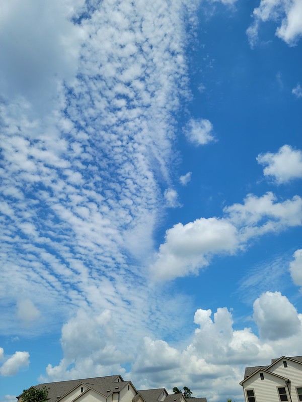
The above picture features some summertime cumulus clouds bubbling up in teh afternoon heat as well as some altocumulus clouds which form from a completely different type of physics.
Ypu may be thinking, “big deal?” Because, this isn’t a rare thing to see, necessarily. Just some clouds. But these types of clouds lined up like this doesn’t happen all the time. And usually it is easy to pick out if you know what you are looking for.
But the really, really cool thing is what it tells us about what is happening in the atmosphere and how we can use it to make a forecast for tomorrow without any other weather information whatsoever. In fact, by the time you get done reading this, you will forever be able to forecast the next days weather when you see clouds like this in the afternoon. And you’ll only need to check out the local forecast for the specifics – what time, how much, where, those types of things.
Starting from the bottom
We all know how those summertime cumulus clouds work. The sunshine heats up the ground and through a type of heat transfer called “convection” pockets of air – with a bunch of moisture in it – rise up, cool and condense to form poofy clouds.
That is how you get fair-weather cumulus clouds.
Summertime cumulus clouds usually pack a bit more punch because the convection driving cloud formation has more energy. Why? Because the sun is higher in the sky and is sending more of that energy to the Earth! That increased energy is passed along from the ground into the sky.
That leaves summertime cumulus clouds with an ‘edge’ to them. Look at the image below, taken about 10 minutes after the first picture looking the opposite direction.

You can see some clouds have fuzzy edges and some have sharp edges. Let’s zoom in a bit…

The sharp-edged clouds are the ones that are growing, and the fuzzy-edged clouds are the ones that are no longer growing, or are growing very slowly.
You’ve seen evidence of a similar effect closer to Earth. On a cold day when you let out a big gasp of breath and a big poof of steam flies out, it is very easy to tell the stark contrast between your breath and the cold, dry air. Compared to when you slowly breath out and you may barely be able to tell if you are creating much steam at all.
And these cumulus clouds can grow pretty big. And they can occupy the atmosphere from about 2,000ft off the ground all the way up to about 20,000ft. Once they start to grow higher than that, we call them cumulonimbus
But that explains the cumulus clouds, what about the altocumulus clouds?
In the middle
The altocumulus clouds form from rising air, too! Just not the same type of rising air as the cumulus clouds.
Instead altocumulus clouds form from rising air between about 6,000ft and 20,000ft. But, again, not from air that is rising from the surface.
So how does air rise in the middle of the atmosphere, but not on the ground? A great question, answered by Mass Balance! And quasigeostrophic theory!
MASS BALANCE
The nice thing about the atmosphere is that it wants to be even. So when stuff is uneven, it works as fast as it can to even it out. Here is a slide from my GHY 326 class at USM talking about evening out the atmosphere.

The key here is that high pressure things always want to go toward low pressure things. And this is true for all of physics. Shake up a can of soda and pop the top? High pressure inside wants to go to low pressure outside.
As an aside, and not that anyone asked, but because pressure and temperature are related, this also means that hot things do work on cooler things. It is the reason why the glass of ice water melts on a hot summer day as opposed to it freezing to the table.
So, in the specific case of our altocumulus cloud, the air from a lower altitude has a higher pressure or a higher temperature than an area of higher altitude so it moves toward the area of lower pressure / temperature.
How do we know which one it is – pressure or temperature? For that, we need to look at geostrophic wind.
GEOSTROPHIC WIND
This is a look at how air moves horizontally in the atmosphere and how that horizontal movement can actually induce vertical movement. Yeah, seriously! Moving from side-to-side can actually make air want to move up or down.
Take a look at the graphic below (left), the graphic is looking from the top down. Imagine the atmosphere like a stack of pancakes (right)! And we are taking a look at one of the middle pancakes.


On the side of the pancake furthest from you, there is low pressure and on the side of the pancake nearest you, there is high pressure.
But the air can’t just go straight there! Because the earth is spinning, There is Coriolis Force. For the same reason that wind doesn’t go straight toward the center of a hurricane, the wind bends around the area of low pressure.
And it turns out that as it goes whizzing by in-between Highs and Lows, the air speeds up and slows down. And just like sitting in traffic, sometimes cars are all jammed up and other times when the traffic starts to break apart, cars go speeding ahead.
That is analogous to air pressure. When all the cars are jammed up together, that is higher pressure (convergence) and when they start speeding away, that is lower pressure (divergence).
So looking from the top down again, the air speeds up when leaving a trough and going over a ridge. And where that happens you can fill the void left in the atmosphere by lifting the air from below.
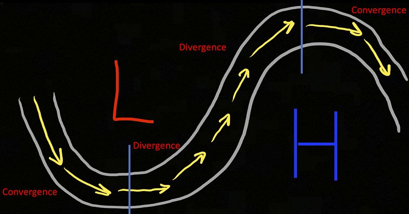
Now, going back to our pancake, imagine each pancake had a different H and L on each one. Creating a very uneven atmosphere. The different in air pressure from the air passing in-between those Hs and Ls would be different, too.
And altocumulus clouds can form when there is faster air (lower pressure) moving by above an area with slower air (high pressure) below. Because the air below wants to lift upward – but not very fast – and from the area of high pressure to lower pressure. We also call this a type of “forcing” in the atmosphere.
You can see this type of forcing when looking at Skew-T data, too. By looking at the “Omega” on the left-hand side. Anywhere you see the purple/megnta horizontal lines, you’ve got “forcing” happening. And it is this type of forcing that led to some of the unexpected snowfalls across South Mississippi during the last five years.

PUTTING THE TWO TOGETHER
I know this was a long journey, but I promise the payoff is awesome!
So! Now that we know we have summertime cumulus happening underneath an area of the atmosphere that is being “forced” we have to ask, well, what is forcing it? There has to be something nearby telling the air to go from one layer of the atmosphere to another.
And BOOM! There it is.

The air coming around the L and moving back north across Mississippi and into the Ohio River Valley and over the H (not drawn here, but out in the Atlantic) is speeding up, meaning the air below that layer of the atmosphere can lift into it, rising, cooling and condensing to form clouds.
From the Top looking down
For proof that this is happening, we can go look at the satellite imagery. And you can see below, there are cumulus clouds moving from SE to NW and altocumulus clouds moving from SW to NE.
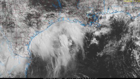
Yuo can also see a bit of sin in the atmosphere back over the border between Texas and Mexico, an indication of an area of low pressure.
Making a forecast
So, now that we have went through and double-checked how we know there is an area of low pressure nearby, we can use this information going forward to note that…
1. When two types of clouds – middle/high clouds and cumulus clouds – exist simultaneously there must be two types of forcing happening.
2. When there are two types of forcing happening in the summer, it means one type is summer heat, the other is from atmospheric conditions.
3. Atmospheric forcing indicates that an area of low pressure is nearby.
4. Low pressure nearby, often means lift is occuring at all levels of the atmosphere.
5. If lift is occuring there is a better chance for rain!
So, is there a chance for rain during the next 24 hours in south Texas?
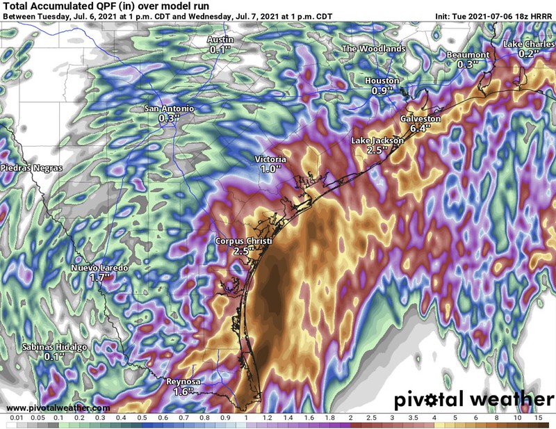
Yes. Somewhere between a “Trace” and 21-inches.
Okay, well, I didn’t say it would give you an exact forecast. But hey, at least you know there is a better chance for rain during the next 24 hours if you see this!


