The area may get a bit of a break today from the rain – but only a bit. It looks like showers and storm will still develop as we head through the afternoon, but they may not be quite as widespread.
That said, ti also looks like Wednesday may feature some extra chances for rain and – honestly – some pretty stout downpours, too. Some of the thunderstorms on Wednesday may feature rainfall rates up over 2″ per hour at times. So the gullies and culverts will fill up quickly if you get stuck under some of the stronger storms on Wednesday.
Part of that will be the influence from Tropical Storm Elsa. It is shoving just a wee bit of extra moisture toward South Mississippi. The other part is that it is July in South Mississippi.
Speaking of the tropics, and looking beyond Elsa, things are going to remain on the calm side for the next few days. But in about another 10-15 days there may be another wave that tries to develop. So, like always during the summer, please check back with the forecast frequently for updates.
Daily Timeline
This is something new I’m going to try to do more often during summertime storms: give a timeline for the best bet for rain.
We all know that every day there is a chance for storms in the summer. But some days that chance if higher than others. And some days the timeline for rain is a bit different – some days it is around lunchtime, while others it is toward supper.
I’ll do my best to highlight the best chance for rain during the next 48 hours. And I’ll be completely transparent wit this: It won’t be perfect for everywhere. Because even if the “best bet” for rain is between 1p and 4p on a random day, there may still be rain that develops at 11a and sticks around till 7p.
But it is an attempt to help yuo guys plan your day a bit better!

So, to read the above chart, you can see that there is a better chance for sun (and some clouds) from 8am till about noon. Then from 12p through 4:59p there is a better chance to see storms than to see sunshine (and some clouds). Then it flips back again starting at 5p through 8p with a better chance for seeing sunshine.
For Wednesday, the window to see rain widens to be from 10a through 6:59p.
Day-to-Day Forecast
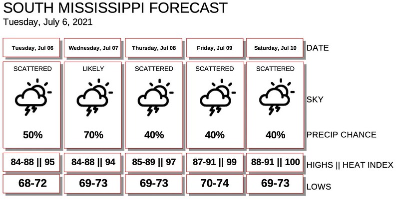
Today
Mostly cloudy with a 50-percent chance for afternoon storms. Highs in the mid 80s.
Tonight
Mostly cloudy with storms ending by midnight. Lows in the lower 70s.
Wednesday
Mostly cloudy with a 60-percent chance for afternoon storms. Highs in the mid 80s.
Wednesday Night
Mostly cloudy. Lows in the lower 70s.
Thursday
Partly cloudy with a 40-percent chance for storms. Highs in the mid 80s.
Thursday Night
Mostly cloudy. Lows in the lower 70s.
Friday
Partly cloudy with a 40-percent chance for storms. Highs in the upper 80s.
Friday Night
Partly cloudy. Lows in the lower 70s.
Saturday
Partly cloudy with a 40-percent chance of showers and thunderstorms. Highs around 90.
Saturday Night
Partly cloudy with a 20 percent chance for rain before midnight. Lows in the lower 70s.
Sunday
Passing clouds with passing storms possible. Highs in the lower 90s. The chance for rain is around 40-percent.
Sunday Night
Partly cloudy. Lows in the lower 70s.
Monday
Mostly sunny. Some storms possible. Highs around 90. The chance of rain 30-percent.
Graphical Forecast