A brief reminder that our Detailed Forecast coverage area tends to just be southern Mississippi — with a few parishes in southeastern Louisiana. This “heat map” of our coverage area is a good gauge to know if we are talking about your area.

A few meaningful changes to the forecast from last night, but nothing major. It looks like the timing of the near-freezing air is a bit sooner but the BIG cold air will be a bit later. And the precip will start a bit earlier., too.
The general timeline puts precipitation in the area from now through early Tuesday morning in varying degrees of intensity – mostly as drizzle and light rain – and varying degrees of frozen and liquid.
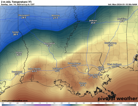
The reason? The cold front draped across the area will not be in a “big” hurry to move. Here is a look at what temperatures will look like around noon tomorrow.

You’re reading that correctly: Some spots will be well-above freezing through noon and into the afternoon tomorrow while other spots hover around the freezing mark.
Responding to that, the NWS has issued a Winter Storm Watch for most of the Mississippi counties and most counties in southeastern Louisiana. And a few of the southern Alabama counties are in there, too. The Winter Storm Warnings are in effect for farther north.
The Watches, Warnings and Advisories map is quite colorful.

But know that if you have plans to drive tomorrow morning and you live south of HWY 84 you probably will be fine (aside from wet roads in some spots).
I repeated: If you’re out in the morning across southern Mississippi, southeastern Louisiana, and Lower Alabama, you’re fine.
Things get interesting later Monday evening.
This is going to be a trickier-than-normal system to shake out specifics with because we will see a bit of a dry-slot in the mid-levels that may limit precipitation for some spots but not others. And it may also shift when the heaviest precipitation falls for some spots, but not others.

And the drier air means that when rain falls through it, it can cool down further. This makes a complicated forecast even more complicated. And it is a wrinkle that we couldn’t have seen 24 hours ago.
And when you ask the computer models to predict how much freezing rain will accumulate, you can see evidence of that dry slot in some of the output. Most of the freezing rain will fall northwest of a line fom about Baton Rouge through Hattiesburg and northeast toward Montgomery.


What does this mean for you? That, too, is complicated. It means that there is an extra wrinkle to the county-by-county forecast below. Because there is a chance that the models are under-cutting the amount of freezing rain in some spots, but over-doing it in others.
I also still think there is an outside shot for a flash freeze in some places where the cold air will move in so fast that the water may not have a chance to evaporate before it freezes.
Then, once the precipitation comes to an end, the big batch of cold air north of the area will come barreling southward. This will invade the area through the day on Tuesday.
That means some folks may fall below freezing late Monday night and not get back above freezing until Wednesday afternoon.
In fact, if you live north of HWY 84, there is a good chance that you hit freezing Monday night after 8pm and then fall below-freezing overnight and, stay there through Tuesday, then get even colder Tuesday night, and don’t get back above freezing until Wednesday afternoon.
This shot of cold air will also set the entire area up for a very cold night Tuesday night and into Wednesday morning. Model guidance is in pretty good agreement that a lot of the area will get down to at least 20F and many spots will fall into the teens.
WINTERIZING TIPS
Hopefully you took some time this weekend to winterize your home, car, and life. If not, here are some tips from the NWS:
- Prepare your family
- Make a Family Communications Plan. Your family may not be together when disaster strikes, so it is important to know how you will contact one another, how you will get back together and what you will do in case of an emergency.
- Make an emergency kit for at least three days of self-sufficiency.
- Keep space heater safety in mind: Use electric space heaters with automatic shut-off switches and non-glowing elements. Remember to keep all heat sources at least three feet away from furniture and drapes.
- Prepare your home:
- Make sure your home is well insulated and that you have weather stripping around your doors and window sills to keep the warm air inside.
- Make sure you have a working carbon monoxide detector.
- Keep fire extinguishers on hand, and make sure everyone in your house knows how to use them. House fires pose an additional risk, as more people turn to alternate heating sources without taking the necessary safety precautions.
- Learn how to shut off water valves (in case a pipe bursts).
- Insulate your home by installing storm windows or covering windows with plastic from the inside to keep cold air out.
- If you have a wood burning fireplace, consider storing wood to keep you warm if winter weather knocks out your heat. Also, make sure you have your chimney cleaned and inspected every year.
- Have at least one of the following heat sources in case the power goes out:
- Extra blankets, sleeping bags and warm winter coats
- Fireplace or wood-burning stove with plenty of dry firewood, or a gas log fireplace
- Prepare your vehicle:
- Fully winterize your vehicle: Have a mechanic check antifreeze, brakes, heater and defroster, tires, and windshield wipers to ensure they are in good shape. Keep your gas tank at least half full.
- Keep an extra emergency kit specifically created for your car. In addition to the basic essentials, consider adding a portable cell phone charger, ice scraper, extra blanket, sand for traction and jumper cables.
- Rock salt or more environmentally safe products to melt ice on walkways. Visit the Environmental Protection Agency for a complete list of recommended products.
- Sand to improve traction.
- Other tidbits
- Make sure you have a cell phone with an emergency charging option (car, solar, hand crank, etc.) in case of a power failure.
- People who depend on electricity to operate medical equipment should have alternate arrangements in place in case power is out for an extended period of time.
- Plan to check on elderly/disabled relatives and neighbors.
- Plan to bring pets inside.
- Know where the manual release lever of your electric garage door opener is located and how to operate it in case you lose power.
- Fill a gallon container with water and place them in the freezer to help keep food cold.
- A NOAA Weather Radio broadcasts alerts and warnings directly from the NWS for all hazards. You may also sign up in advance to receive notifications from your local emergency services.
The cold Tuesday night and into Wednesday morning will likely be cold enough that some folks will need to drip faucets and open cupboards under the sink to make certain that pipes don’t burst.
TRAVEL
If you have to get out and drive tomorrow, please consult the county-by-county forecast to see when the liquid precip will change over to icy precip. But on top of that, know that…
MOST AREAS – Icy spots in low-lying areas, minor impacts to travel with slick roads and ice on bridges and overpasses likely for up to 6 hours
MANY PLACES – Icy spots on less-traveled roads with icy bridges and overpasses for up to 9 hours
SOME SPOTS – Freezing rain accumulated on surfaces with icy roads for up to 12 hours
FEW LOCATIONS – Impassable due to icy roads
This isn’t going to be an “everywhere” problem, but it may be a problem for you, so please drive carefully if you have to be out and about.
COUNTY-BY-COUNTY BREAKDOWN
For certain events I will try to cover as many counties as possible but please know that it takes a LOT of time to put these together. If I don’t cover your county it isn’t because I don’t care, but rather because there are only so many hours in the day.
So… Let’s take a look!
I-20 CORRIDOR
HINDS COUNTY
There is a risk for liquid rain to change to freezing rain and sleet quickly. This may result in accumulating ice on surfaces and trees.
TIMELINE:
- Sunday 11pm – light precipitation may begin
- Monday 5am – Freezing drizzle and light sleet begins
- Monday 11am – Freezing rain and sleet increases intensity
- Monday 5pm – Freezing rain and sleet ease back to patchy freezing drizzle and patchy light sleet
- Tuesday 1am – Precipitation ends
Total accumulations look to be between 0.05″ and 0.15″
COPIAH COUNTY
There is a risk for liquid rain to change to freezing rain and sleet quickly. This may result in accumulating ice on surfaces and trees.
TIMELINE:
- Sunday 11pm – light precipitation may begin
- Monday 5am – Freezing drizzle and light sleet begins
- Monday 11am – Freezing rain and sleet increases intensity
- Monday 5pm – Freezing rain and sleet ease back to patchy freezing drizzle and patchy light sleet
- Tuesday 1am – Precipitation ends
Total accumulations look to be between 0.05″ and 0.15″
RANKIN COUNTY
There is a risk for liquid rain to change to freezing rain and sleet quickly. This may result in accumulating ice on surfaces and trees.
TIMELINE:
- Sunday 11pm – light precipitation may begin
- Monday 6am – Freezing drizzle and light sleet begins
- Monday 11am – Freezing rain and sleet increases intensity
- Monday 5pm – Freezing rain and sleet ease back to patchy freezing drizzle and patchy light sleet
- Tuesday 1am – Precipitation ends
Total accumulations look to be between 0.05″ and 0.15″
SIMPSON COUNTY
There is a risk for liquid rain to change to freezing rain and sleet quickly. This may result in accumulating ice on surfaces and trees.
TIMELINE:
- Monday 3am – Drizzle begins
- Monday 8am – Drizzle changes over to a freezing rain and sleet
- Monday 6pm – Freezing rain and sleet ease back to patchy freezing drizzle and patchy light sleet
- Tuesday 3am – Precipitation ends
Total accumulations look to be between 0.05″ and 0.15″
SCOTT COUNTY
There is a risk for liquid rain to change to freezing rain and sleet quickly. This may result in accumulating ice on surfaces and trees.
TIMELINE:
- Monday 3am – Drizzle begins
- Monday 7am – Drizzle changes over to freezing rain and sleet
- Monday 6pm – Freezing rain and sleet ease back to patchy freezing drizzle and patchy light sleet
- Tuesday 3am – Precipitation ends
Total accumulations look to be between 0.05″ and 0.15″
SMITH COUNTY
There is a risk for liquid rain to change to freezing rain and sleet quickly. This may result in accumulating ice on surfaces and trees.
TIMELINE:
- Monday 3am – Drizzle begins
- Monday 9am – Drizzle changes over to freezing rain and sleet
- Monday 6pm – Freezing rain and sleet ease back to patchy freezing drizzle and patchy light sleet
- Tuesday 3am – Precipitation ends
Total accumulations look to be between 0.05″ and 0.15″
NEWTON COUNTY
There is a risk for liquid rain to change to freezing rain and sleet quickly. This may result in accumulating ice on surfaces and trees.
TIMELINE:
- Monday 3am – Drizzle begins
- Monday 9am – Drizzle changes over to freezing rain and sleet
- Monday 6pm – Freezing rain and sleet ease back to patchy freezing drizzle and patchy light sleet
- Tuesday 3am – Precipitation ends
Total accumulations look to be between 0.05″ and 0.15″
JASPER COUNTY
The forecast data supports things starting out as liquid precipitation but then changing over to a mix and then finally to freezing rain and sleet before coming to an end Tuesday morning.
- Monday 3am – Drizzle begins
- Monday 12pm – Drizzle changes over to freezing rain and sleet
- Monday 6pm – Freezing rain and sleet ease back to patchy freezing drizzle and patchy light sleet
- Tuesday 3am – Precipitation ends
Total accumulations look to be under 0.05″
LAUDERDALE COUNTY
The forecast data supports things starting out as liquid precipitation but then changing over to a mix and then finally to freezing rain and sleet before coming to an end Tuesday morning.
- Monday 3am – Drizzle begins
- Monday 1pm – Drizzle changes over to freezing rain and sleet
- Monday 6pm – Freezing rain and sleet ease back to patchy freezing drizzle and patchy light sleet
- Tuesday 3am – Precipitation ends
Total accumulations look to be under 0.05″
CLARKE COUNTY
The forecast data supports things starting out as liquid precipitation but then changing over to a mix and then finally to freezing rain and sleet before coming to an end Tuesday morning.
- Monday 3am – Drizzle begins
- Monday 2pm – Drizzle changes over to freezing rain and sleet
- Monday 6pm – Freezing rain and sleet ease back to patchy freezing drizzle and patchy light sleet
- Tuesday 3am – Precipitation ends
Total accumulations look to be under 0.05″
HWY 84 CORRIDOR
LINCOLN COUNTY
The forecast data supports things starting out as liquid precipitation but then changing over to a mix and then finally to freezing rain and sleet before coming to an end Tuesday morning.
- Monday 7am – Drizzle begins
- Monday 3pm – Liquid rain changes over to freezing drizzle and light sleet
- Monday 7pm – Freezing rain and sleet increases intensity
- Tuesday 2am – Precipitation ends
Total accumulations look to be under 0.05″
LAWRENCE COUNTY
The forecast data supports things starting out as liquid precipitation but then changing over to a mix and then finally to freezing rain and sleet before coming to an end Tuesday morning.
- Monday 7am – Drizzle begins
- Monday 3pm – Liquid rain changes over to freezing drizzle and light sleet
- Monday 8pm – Freezing rain and sleet increases intensity
- Tuesday 3am – Precipitation ends
Total accumulations look to be under 0.05″
JEFF DAVIS COUNTY
The forecast data supports things starting out as liquid precipitation but then changing over to a mix and then finally to freezing rain and sleet before coming to an end Tuesday morning.
- Monday 7am – Drizzle begins
- Monday 4pm – Liquid rain changes over to freezing drizzle and light sleet
- Monday 10pm – Freezing rain and sleet increases intensity
- Tuesday 2am – Precipitation ends
Total accumulations look to be under 0.05″
COVINGTON COUNTY
The forecast data supports things starting out as liquid precipitation but then changing over to a mix and then finally to freezing rain and sleet before coming to an end Tuesday morning.
- Monday 7am – Drizzle begins
- Monday 6pm – Liquid rain changes over to freezing drizzle and light sleet
- Monday 11pm – Freezing rain and sleet increases intensity
- Tuesday 3am – Precipitation ends
Total accumulations look to be under 0.05″
JONES COUNTY
The forecast data supports things starting out as liquid precipitation but then changing over to a mix and then finally to freezing rain and sleet before coming to an end Tuesday morning.
- Monday 7am – Drizzle begins
- Monday 6pm – Liquid rain changes over to freezing drizzle and light sleet
- Monday 11pm – Freezing rain and sleet increases intensity
- Tuesday 3am – Precipitation ends
Total accumulations look to be under 0.05″
WAYNE COUNTY
There will be a brief window where liquid rain may mix with sleet and change-over to freezing rain and sleet for a short window.
- Monday 8am – Drizzle begins
- Monday 7pm – drizzle changes over to a mix of freezing drizzle and light sleet
- Tuesday 1am – Wintry mix turns to all freezing rain and sleet
- Tuesday 4am – Precipitation ends
Total accumulations look to be under 0.05″
HWY 98 CORRIDOR
PIKE COUNTY
The forecast data supports things starting out as liquid precipitation but then changing over to a mix and then finally to freezing rain and sleet before coming to an end Tuesday morning.
- Monday 7am – Drizzle begins
- Monday 3pm – Liquid rain changes over to freezing drizzle and light sleet
- Monday 6pm – Freezing rain and sleet increases intensity
- Tuesday 1am – Precipitation ends
Total accumulations look to be under 0.05″
WALTHALL COUNTY
There will be a brief window where liquid rain may mix with sleet and change-over to freezing rain and sleet for a short window.
- Monday 7am – Drizzle begins
- Monday 3pm – Liquid rain changes over to freezing drizzle and light sleet
- Monday 6pm – Heaviest freezing rain and sleet occurs
- Tuesday 1am – Precipitation ends
Total accumulations look to be under 0.05″
MARION COUNTY
There will be a brief window where liquid rain may mix with sleet and change-over to freezing rain and sleet for a short window.
- Monday 8am – Drizzle begins
- Monday 4pm – Drizzle changes over to a mix of freezing drizzle and light sleet
- Monday 7pm – Wintry mix turns to all freezing rain and sleet
- Tuesday 1am – Precipitation ends
Total accumulations look to be under 0.05″
LAMAR COUNTY
There will be a brief window where liquid rain may mix with sleet and change-over to freezing rain and sleet for a short window.
- Monday 8am – Drizzle begins
- Monday 5pm – Drizzle changes over to a mix of freezing drizzle and light sleet
- Monday 7pm – Wintry mix turns to all freezing rain and sleet
- Tuesday 2am – Precipitation ends
Total accumulations look to be under 0.05″
FORREST COUNTY
There will be a brief window where liquid rain may mix with sleet and change-over to freezing rain and sleet for a short window.
- Monday 8am – Drizzle begins
- Monday 6pm – Drizzle changes over to a mix of freezing drizzle and light sleet
- Monday 8pm – Wintry mix turns to all freezing rain and sleet
- Tuesday 3am – Precipitation ends
Total accumulations look to be under 0.05″
PERRY COUNTY
There will be a brief window where liquid rain may mix with sleet and change-over to freezing rain and sleet for a short window.
- Monday 8am – Drizzle begins
- Monday 6pm – Drizzle changes over to a mix of freezing drizzle and light sleet
- Monday 8pm – Wintry mix turns to all freezing rain and sleet
- Tuesday 3am – Precipitation ends
Total accumulations look to be under 0.05″
GREENE COUNTY
Mostly liquid precipitation for here but there will be a brief mixture of wintry precip.
- Monday 8am – Drizzle begins
- Monday 6pm – Drizzle changes over to a mix of freezing drizzle and light sleet
- Monday 9pm – Wintry mix turns to all freezing rain and sleet
- Tuesday 3am – Precipitation ends
No meaningful accumulation is anticipated (at this time)
HWY 26 CORRIDOR
PEARL RIVER COUNTY
Mostly liquid precipitation for here but there will be a brief mixture of wintry precip.
- Monday 8am – Drizzle begins
- Monday 6pm – Drizzle changes over to a mix of freezing drizzle and light sleet
- Tuesday 1am – Wintry mix turns to all freezing rain and sleet
- Tuesday 3am – Precipitation ends
No meaningful accumulation is anticipated (at this time)
STONE COUNTY
Mostly liquid precipitation for here but there will be a brief mixture of wintry precip.
- Monday 8am – Drizzle begins
- Monday 6pm – Drizzle changes over to a mix of freezing drizzle and light sleet
- Tuesday 12am – Wintry mix turns to all freezing rain and sleet
- Tuesday 2am – Precipitation ends
No meaningful accumulation is anticipated (at this time)
GEORGE COUNTY
Mostly liquid precipitation for here but there will be a brief mixture of wintry precip.
- Monday 8am – Drizzle begins
- Monday 7pm – Drizzle changes over to a mix of freezing drizzle and light sleet
- Tuesday 2am – Precipitation ends
No meaningful accumulation is anticipated (at this time)
COASTAL MISSISSIPPI
HANCOCK COUNTY
Mostly liquid precipitation for here but there will be a brief mixture of wintry precip.
- Monday 8am – Drizzle begins
- Monday 7pm – Drizzle changes over to a mix of freezing drizzle and light sleet
- Tuesday 2am – Precipitation ends
No meaningful accumulation is anticipated (at this time)
HARRISON COUNTY
Mostly liquid precipitation for here but there will be a brief mixture of wintry precip.
- Monday 8am – Drizzle begins
- Monday 7pm – Drizzle changes over to a mix of freezing drizzle and light sleet
- Tuesday 2am – Precipitation ends
No meaningful accumulation is anticipated (at this time)
JACKSON COUNTY
Mostly liquid precipitation for here but there will be a brief mixture of wintry precip.
- Monday 8am – Drizzle begins
- Monday 7pm – Drizzle changes over to a mix of freezing drizzle and light sleet
- Tuesday 2am – Precipitation ends
No meaningful accumulation is anticipated (at this time)
ALABAMA COUNTIES
SUMTER COUNTY
The forecast data supports things starting out as liquid precipitation but then changing over to a mix and then finally to freezing rain and sleet before coming to an end Tuesday morning.
- Monday 3am – Drizzle begins
- Monday 1pm – Drizzle changes over to freezing rain and sleet
- Monday 6pm – Freezing rain and sleet ease back to patchy freezing drizzle and patchy light sleet
- Tuesday 3am – Precipitation ends
Total accumulations look to be under 0.05″
CHOCTAW COUNTY
There will be a brief window where liquid rain may mix with sleet and change-over to freezing rain and sleet for a short window.
- Monday 11pm – Liquid rain begins
- Tuesday 5am – Liquid rain changes over to freezing rain and sleet
- Tuesday 11am – Precipitation ends
Total accumulations look to be under 0.05″
WASHINGTON COUNTY
There will be a brief window where liquid rain may mix with sleet and change-over to freezing rain and sleet for a short window.
- Monday 8am – Drizzle begins
- Monday 6pm – Drizzle changes over to a mix of freezing drizzle and light sleet
- Monday 9pm – Wintry mix turns to all freezing rain and sleet
- Tuesday 3am – Precipitation ends
Total accumulations look to be under 0.05″
MOBILE COUNTY Mostly liquid precipitation for here but there will be a brief mixture of wintry precip.
- Monday 8am – Drizzle begins
- Monday 7pm – Drizzle changes over to a mix of freezing drizzle and light sleet
- Tuesday 2am – Precipitation ends
No meaningful accumulation is anticipated (at this time)
LOUISIANA PARISHES
TANGIPAHOA PARISH
Mostly liquid precipitation for here but there will be a brief mixture of wintry precip.
- Monday 6am – Drizzle begins
- Monday 6pm – Drizzle changes over to a mix of freezing drizzle and light sleet
- Tuesday 3am – Precipitation ends
No meaningful accumulation is anticipated (at this time)
ST. TAMMANY PARISH
Mostly liquid precipitation for here but there will be a brief mixture of wintry precip.
- Monday 6am – Drizzle begins
- Monday 6pm – Drizzle changes over to a mix of freezing drizzle and light sleet
- Tuesday 3am – Precipitation ends
No meaningful accumulation is anticipated (at this time)
WASHINGTON PARISH
Mostly liquid precipitation for here but there will be a brief mixture of wintry precip.
- Monday 6am – Drizzle begins
- Monday 6pm – Drizzle changes over to a mix of freezing drizzle and light sleet
- Tuesday 3am – Precipitation ends
No meaningful accumulation is anticipated (at this time)
THE BOTTOM LINE
There is a good shot for some rain and drizzle tonight through most of tomorrow. Rainfall totals will be pretty light.
Cold air will start to push into the area during the day tomorrow. Depending on your location it may take longer than other spots. That cold air may slide underneath the falling precipitation which will set us up for a chance for freezing rain and sleet. The total amount of freezing rain and sleet for each location will be dictated by how fast the cold air moves in and how fast the precipitation moves out.
By Tuesday morning, most of the area will be near freezing. And the rain will be over. Then Tuesday many spots will only warm back to around 30F to 35F as the real cold air presses toward the Gulf.
Overnight Tuesday and into Wednesday morning, we drop down into the teens in many spots (perhaps even colder farther north).


I guess I keep repeating myself but I wish the animation loop was where I could pause it. It makes it difficult to watch the time and where I am located at the same time. Other than that, this is a MUCH more detailed report on what is, and will be, going on from this (Monday) morning through Tuesday morning. Looks like the NWS would do the same but, oh well. Than you VERY much for continuing to look out after us when you don’t have to! 🙂
I know it! I apologize. I had developed a work-around for a while that worked great. But then it failed. I’m still trying to find a way to build a “viewer” for these.