Good news and bad news today. The bad news is that the potential for severe weather persists across the area for Wednesday/Thursday. The good news is that the signal for significant severe weather isn’t as robust today within the data.
Recall yesterday, I walked through all of the data from not only the forecast models but also the CIPS Analogs data. And while the forecast data wasn’t quite as sold on severe weather, the CIPS Analogs data was quite adamant.
Today’s model data shows a lower threat and the CIPS Analogs also show a lower threat.
But there is still a threat.
REMINDER: IF YOU HAVE AN ANDROID PHONE, YOU LEARN ABOUT & DOWNLOAD OUR NEW APP BY TAPPING HERE! IF YOU ARE AN APPLE USER, THAT APP WILL BE AVAILABLE SOON. IT IS STILL CURRENTLY, IN DEVELOPMENT.
THE DATA
Model guidance continues to show a thin line of storms set to pass through the area along a cold front. The storms should pass through, based on the model trends, late Wednesday night and into early Thursday morning.
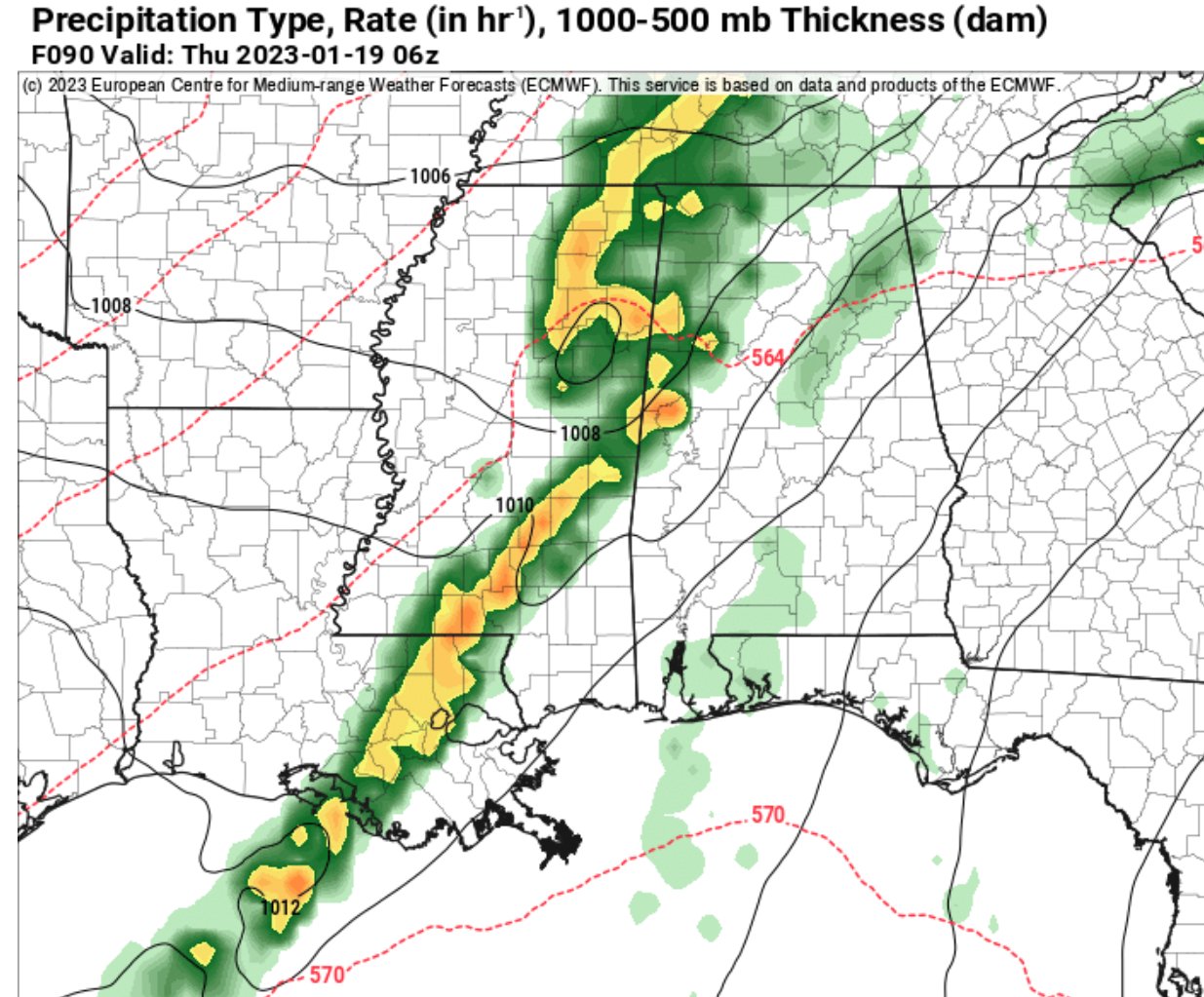


The second image above, the Skew-T chart, shows a loosely-convective atmosphere. But I tend to think the models are under-doing the low-level moisture and warmth (they did this with the past even, too) and that is limiting how convective the atmosphere looks on the data.
If you look at that Skew-T and add just 3F to the temperature and dewpoint the atmosphere jumps from barely convective to very convective.

The numbers above, break down like this…
SWEAT
150-300 Slight severe
300-400 Severe possible
400+ Tornadic possible
Total Totals
<44 Convection not likely
44-50 Likely thunderstorms
51-52 Isolated severe storms
53-56 Widely scattered severe
56 Scattered severe storms
K Index
15-25 Small convective potential
26-39 Moderate convective potential
40+ High convective potential
BRN
<45 Supercells favorable
<10 Too sheared
teens Optimum
This next event may be one of those, “how much sunshine are you seeing ahead of the storms?” kind of days. The more sun, the more heat, the more convective the storms. And since these are rolling through overnight, the previous day (Wednesday) will be the indicator for just how warm the area gets and how warm it may stay overnight.
The CIPS data is a bit calmer today. Only seven of the Top 15 Analogs featured severe weather across the region on today’s data. Yesterday it was 11.
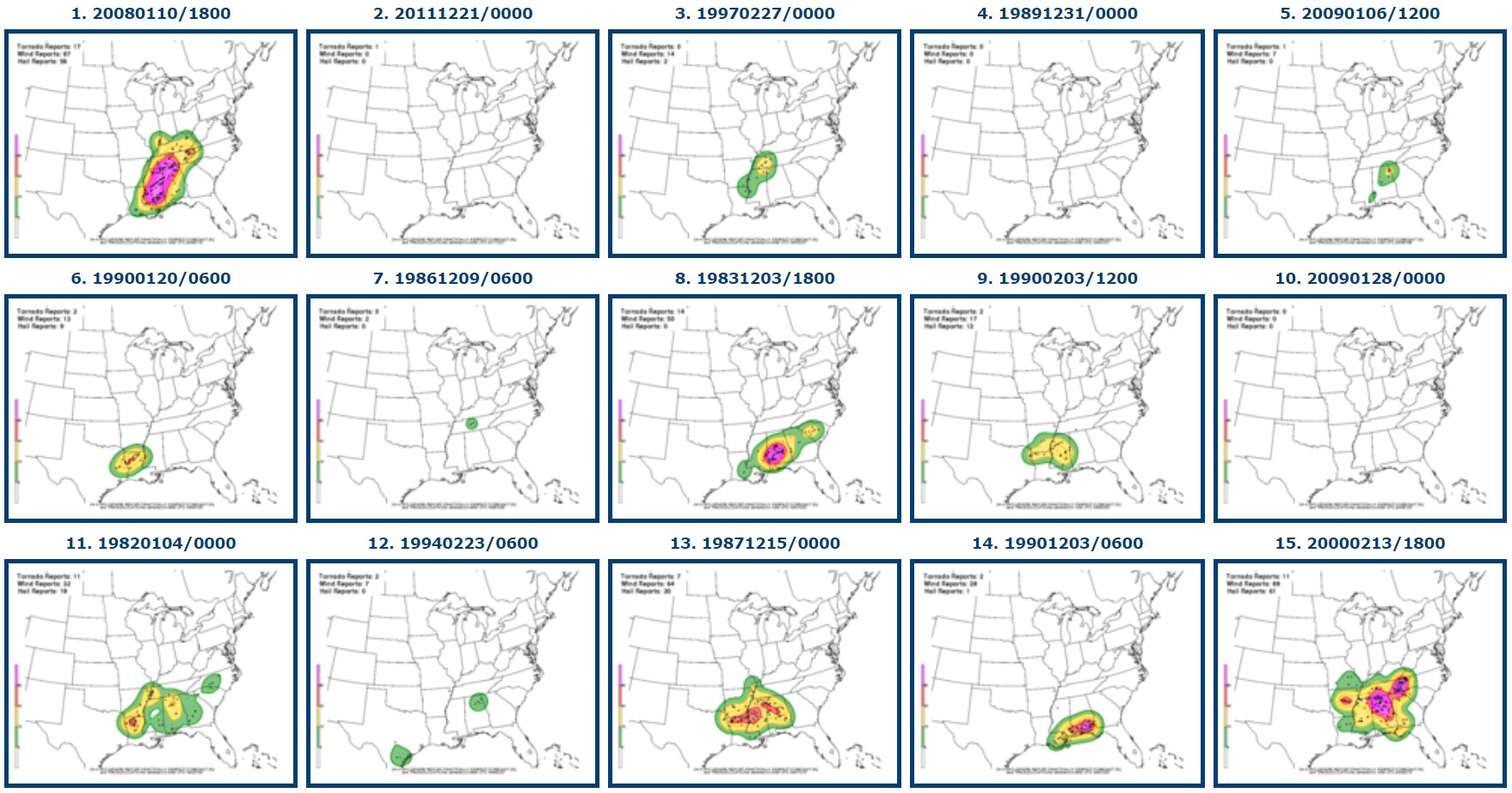
When looking at the number of the Top 15 Analogs above that show more than five severe reports in an area, the percentage is down to around 30-percent today. Yesterday it was closer to 60-percent.

The numbers are lower, but the are still far from zero. That is why the SPC is maintaining their Slight Risk for severe weather across parts of the region.


Miss Nik in MS!!