I’m not overly impressed with the setup for widespread severe weather across south Mississippi, but it is also enough to see a few isolated storms.
The Storm Prediction Center has increased the Risk today to a Slight Risk. This same system definitely over-produced last night across the Houston area (I was under a tornado warning which passed to my southeast) and my guess would be they are looking at the data and seeing a similar setup across Mississippi and Alabama and thinking they same situation may develop for the region.

The model guidance is likely under-doing the overall coverage and potential, due to this system over-performing. The 12z HRRR computer weahter model, for example, one of our better short-range models, has nearly nothing all day long.
Then a weak line of storms pushes through the region with some brief heavy rain, gusty wind and lightning.
But there may be a bit more push to this system.
Quick data crunch / Karrie Meter
The one computer weather model that does show something is the HRW-FV3 computer weather model. And I think it may be on to something. I don’t know that it has all the puzzle pieces in the right place, but I think it probably has the best handle on what all the puzzle pieces look like.
And it shows a few storms developing – rotating storms, at that – ahead of the line as it moves through the region.
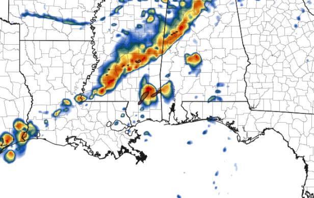
Again, I wouldn’t get too caught up in where either of the three blobs of storms ahead of the line of storms are located, as I don’t think that is right. But I do think there will be a few storms that fire up ahead of the line of storms.
And those storms will be moving through an atmosphere that is conducive for the development of severe weather. Not significant severe weather, but some gusty wind, small hail and the potential for a brief and weak torando.
The Karrie Meter shows a thumb of “4” to “5” pushing into Louisiana, Mississippi and Alabama through teh day today.


While the threat isn’t terribly high, I also don’t think it is terribly low. Particularly for an isolated severe storms or two. Nothing too crazy, but keep an eye to the sky and don’t put your phone on silent today, so you can get pinged if a warning is issued for your area.
The Bottom Line
It looks like there will be a chance for a few isolated storms to develop this afternoon. That will be Round 1.
Round 1
A few showers and storms with heavy rain, wind gusts up over 60mph, small hail and the chance for a brief tornado. Not everyone will see storms in Round 1. In fact, I tend to think only a few spots will see storms. from Round 1. The timeline on this threat will be between about 11a and 4p.
Round 2
This will feature a line of storms that pushes through the area a bit later this afternoon and into the early evening hours. I think everyone sees some rain, gusty wind and lightning from Round 2. It won’t last terribly long, or be too intense for most people. But for a few spots, it may feature some longer-duration heavy rain, and stronger wind. The timeline on this threat will be between about 1p and 7p.
Thankfully there is no Round 3.
The two rounds do overlap a bit. It looks like the highest risk for severe weather will be with Round 1. We can’t rule it out with Round 2.


