Through most of the day yesterday, Hurricane Delta re-organized and intensified. It, steadily, grew from a Tropical Storm to a Category 2 Hurricane. This morning, it continues to strengthen and will likely make it to a Category 4 Hurricane now, before landfall with Mexico.

The good news – if there is such a thing – is that this is a pretty compact storm. A lot of the wind is closer toward the center of the system. At last check from the data available from the Hurricane Hunters, hurricane-force winds extend outward up to 25 miles from the center and tropical-storm-force winds extend outward up to 90
miles. Putting the strongerst wind very close to the extreme center of this storm.
And until this goes through an Eyewall Replacement Cycle, that wind field is likely to stay about the same.
Latest from the NHC
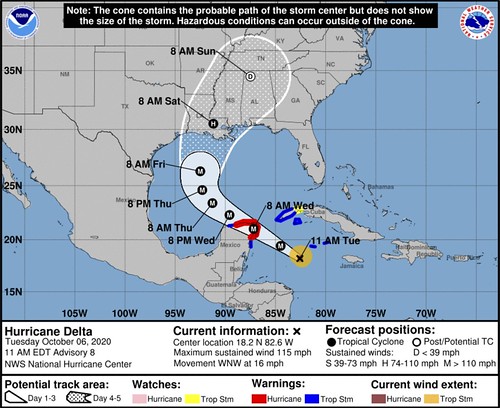
SUMMARY OF 1100 AM EDT
LOCATION…18.2N 82.6W
ABOUT 320 MI…520 KM ESE OF COZUMEL MEXICO
ABOUT 120 MI…190 KM SW OF GRAND CAYMAN
MAXIMUM SUSTAINED WINDS…115 MPH…185 KM/H
PRESENT MOVEMENT…WNW OR 300 DEGREES AT 16 MPH…26 KM/H
MINIMUM CENTRAL PRESSURE…955 MB…28.20 INCHES
FORECAST POSITIONS AND MAX WINDS
INIT 06/1500Z 18.2N 82.6W 100 KT 115 MPH
12H 07/0000Z 19.4N 84.5W 120 KT 140 MPH
24H 07/1200Z 21.0N 87.2W 120 KT 140 MPH
36H 08/0000Z 22.3N 89.6W 105 KT 120 MPH
48H 08/1200Z 23.4N 91.3W 110 KT 125 MPH
60H 09/0000Z 24.6N 92.3W 115 KT 130 MPH
72H 09/1200Z 26.3N 92.5W 110 KT 125 MPH
96H 10/1200Z 30.5N 91.2W 70 KT 80 MPH…INLAND
120H 11/1200Z 34.5N 87.5W 25 KT 30 MPH…POST-TROP/REMNT LOW
OUTLOOK
At 1100 AM EDT (1500 UTC), the center of Hurricane Delta was located near latitude 18.2 North, longitude 82.6 West. Delta is moving toward the west-northwest near 16 mph (26 km/h). A west-northwestward to northwestward motion is expected over the next couple of days. A slower northwestward to north-northwest motion is forecast to begin by late Wednesday or Wednesday night. On the forecast track, the center of Delta is expected to continue to pass southwest of the Cayman Islands through early this
afternoon, and move over the northeastern portion of the Yucatan peninsula late tonight or early Wednesday. Delta is forecast to move over the southern Gulf of Mexico Wednesday afternoon, and be over the southern or central Gulf of Mexico through Thursday.
Reports from a NOAA Hurricane Hunter aircraft indicate that the maximum sustained winds have increased to near 115 mph (185 km/h) with higher gusts. Delta is a category 3 hurricane on the Saffir-Simpson Hurricane Wind Scale. Additional strengthening is forecast during the next 24 hours, and Delta is forecast to be an extremely dangerous category 4 hurricane when it reaches the Yucatan peninsula Wednesday. Although some weakening is likely when Delta moves over the Yucatan peninsula, re-strengthening is forecast when the hurricane moves over the southern Gulf of Mexico.
Hurricane-force winds extend outward up to 25 miles (35 km) from the center and tropical-storm-force winds extend outward up to 90 miles (150 km).
The estimated minimum central pressure from NOAA reconnaissance aircraft data is 955 mb (28.20 inches).
KEY MESSAGES
1. Extremely dangerous storm surge and hurricane conditions are expected within portions of the northern Yucatan Peninsula of Mexico beginning tonight, and a Hurricane Warning is in effect.
2. Heavy rainfall will affect portions of the Cayman Islands, western Cuba and the northern Yucatan Peninsula through midweek. This rainfall could lead to significant flash flooding and mudslides. The potential for heavy rain and flash flooding will increase across portions of the central Gulf Coast, Tennessee Valley, and southeastern United States as Delta moves inland later this week.
3. There is an increasing likelihood of life-threatening storm surge and dangerous hurricane-force winds, especially along the coasts of Louisiana and Mississippi, beginning on Friday. Residents in these areas should ensure they have their hurricane plan in place and monitor updates to the forecast.
TECHNICAL DISCUSSION
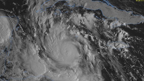
Satellite imagery and recent NOAA Hurricane Hunter aircraft data show that Delta is a very symmetric and compact hurricane. The aircraft reported a tiny 5-nmi-wide eye, which has also been seen in radar imagery from the Cayman Islands, and there is a hint of a pinhole eye in infrared satellite data. The central pressure has continued to fall, with the lastest center dropwindsonde data supporting a pressure of 955 mb. The plane has reported a peak flight-level winds of 109 kt, and believable SFMR winds of 102 kt. Therefore, the initial intensity is set at 100 kt, making Delta the third major hurricane of the 2020 Atlantic hurricane season.
Delta has continued to rapidly strengthen over the past 24 hours, with an estimated 55-kt increase in wind speed between 1200 UTC Monday and 1200 UTC today. Environmental conditions of low vertical wind shear, deep warm waters, and sufficient mid-level moisture are expected to support additional rapid intensification through today, and the only reason that the strengthening could slow is if a difficult-to-predict eyewall replace cycle begins. The SHIPS Rapid intensification index continues to indicate a high likelihood of at least an additional 25-30 kt of intensity increase before the system reaches the northeastern portion of the Yucatan Peninsula. Given that, the NHC intensity forecast is above the various intensity aids and call for Delta to be an extremely dangerous category 4 hurricane when it nears the Yucatan. It could be stronger than indicated below since landfall is predicted to occur between the 12 and 24 h forecast points. Some reduction in intensity is likely when Delta moves over land, but the environmental conditions over the southern Gulf of Mexico are expected to support re-strengthening, and the NHC intensity forecast shows a second peak in 48-72 hours. As mentioned before, increasing southwesterly shear and cooler shelf waters near the northern Gulf coast are expected to cause some reduction in wind speed, but Delta is still expected to be a dangerous hurricane when it nears the northern Gulf coast.
Delta is moving west-northwestward at about 14 kt. A mid-level ridge that extends westward across Florida and the northeastern Gulf of Mexico should continue to steer Delta west-northwestward to northwestward during the next couple of days. As the hurricane nears the western portion of the ridge it should slow down. By day three a developing trough over the south-central United States is expected to cause Delta to turn northward toward the northern Gulf coast. The track guidance is tightly clustered through 48 hours, but there is still a fair amount of spread thereafter regarding the timing and details of the northward turn. The ECMWF and its ensemble mean are well west of the bulk of the remainder of the guidance. The NHC track lies near the TVCA multi-model consensus which is close to a blend of the GFS, HWRF, UKMET ensemble mean.
Model data
No “big” changes overnight. But there were some small changes that will have big ramifications. More of the model data, not just a few outliers, are now suggesting Delta will make it to a Category 4 Hurricane. And a few outliers are showing the potential to reach Category 5 strength.
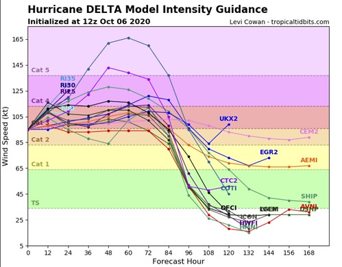
While that isn’t a “big” change, it does have down-the-road ramifications once it gets closer to the northern Gulf Coast.
Since the forecast includes a weakening system as it continues to move north across cooler waters and into an area with more shear, the stronger the storm is originally, the more resistant it will be to the effects of the wind shear. And, even if it is weakening from cooler water, the farther it will have to weaken to drop to a Category 2 Hurricane (which is the forecast for landfall).
So small changes in the data in the short term may mean a bigger change down the line.
The model data guidance for the track of Delta continues to shift to the west, too.
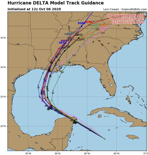
However, for every shift westward during Delta’s time in the Gulf, it makes that much more headway back to the east as it approaches the coastline.
Here is a look at the HWRF model. This shows landfall around Morgan City, Louisiana.
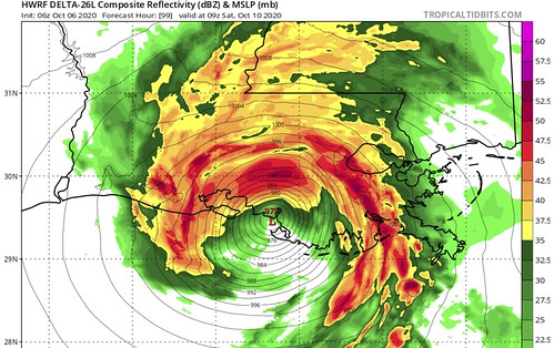
24 hours ago, the landfall point from teh same model was near Dulac, Louisiana. Roughly 35 miles to the southeast.
So the landfall point hasn’t changed much, compared to how far to the west it may traverse during its time in the Gulf – according to this one model.
Water Temperatures
There is some new research out there that I haven’t read yet indicating that the isotherm in the Gulf may be more important than originally thought. I haven’t read the research paper yet, but the premise is that the weaker tropical systems during the past few years have mixed out the “much cooler” water and left a Gulf with “very warm,” “warm,” and “not as warm” waters. Compared to in decades past when hurricanes and cold fronts would really mix out some of the “very warm” water with “much cooler” water.
The researchers claim this may be why we’ve seen hurricanes continue to strengthen so close to landfall in the Gulf in recent years.
I’m trying to find this paper, but I haven’t had a chance to get my hands on it yet. I am intrigued, though.
Back to the current conditions, though. The good news is that the Gulf of Mexico is not the Hot Tub it was just a month ago. There are a few spots that have markedly cooler-than-in-August spots.

The above strip is a look at the Tropical Cyclone Heat Potential, 25C Isotherm, and the Sea Height Anomaly for the Gulf of Mexico. Those numbers are quite a bit lower today than the last time a tropical cyclone threatened the northern Gulf Coast.
Here is the Tropical Cyclone Heat Potential map for the Gulf when Hurricane Sally passed through.
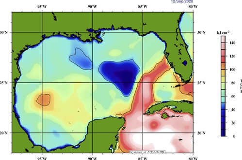
That said, here is that same map in the days leading up to Hurricane Michael.

So while we are in a better position as far as water temperatures go compared to a month ago. We are still on-pace with the last time a Major Hurricane formed in the Gulf. So, we can’t simply look at the water temperatures and go, “well, no biggie, the temps are cooler.”
Despite many who are trying to wave-off any concern.
What to expect & timeline
Since this is now pegged to move further west in the Gulf, it will also slow down the arrival time for the Gulf Coast. Here is a quick look at the potential for landfall and the onset of tropical-storm-force wind.
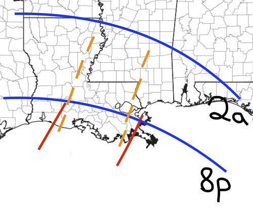
The red lines show, given the latest available data, the extent of the most likely landfall points along the Louisiana coastline. The blue lines show the most likely time for the onset of tropical-storm-force wind. The line closest tot he coast shows Friday at 8pm. The line farther inland is 2am on Saturday morning.
The orange dashed lines show, given the latest available data, the most likely extent of the strongest wind during landfall.
How strong? Generally, greater than hurricane-force is possible. Specifically? That is still an unknown. But given the data we have access to, that is the most likely area to see the strongest.
This area may shift in the coming days, too. So please keep checking back for updates.
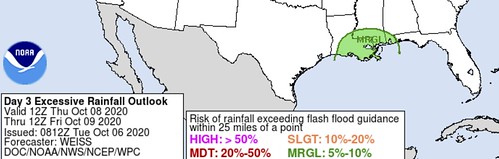
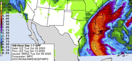
As far as the rain is concerned, the Weather Prediction Center has tagged parts of Louisiana and Mississippi with a Marginal Risk for flash flooding through Friday morning. Friday afternoon through Saturday is still too far out for WPC forecasts.
But the seven-day rainfall totals for the region show a wide area of up to five inches of rain.
Bottom Line
Look over your Hurricane Preparedness Kit now. Double check your supplies, food and water. Do you have all of the medications you’ll need? COVID-related supplies?
Take the time now to go around your home and make sure all dead branches are out of the trees and that water can easily flow away from your home.
There is still a lot left to determine about the specific track. And the final landfall point is not set in stone. Far from it. But we are starting to get a glimpse at what things may look like. Please continue to keep up with the forecast and check back for updates.


