Hurricane Delta is making a good effort to get better organized and strengthen tonight. The Category 1 Hurricane spent most of the day wrapping around the centralized area of low pressure and is now in the throes of Rapid Intensification.
You can tell it looks “healthier” in the GIF above during the last few frames versus the first few frames.
Now, the question is where it is going and what will it do when it gets there.
Right Now
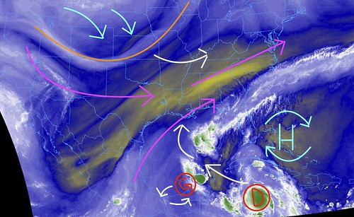
Above is a look at the mid-level water vapor imagery. It shows the ridge of high pressure near the Bahamas, Hurricane Delta, post-tropical Gamma, and the troughiness to the northwest.
These are puzzle pieces during the next few days. With one wildcard.
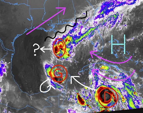
The red “?” is the wildcard. Albeit, not much of one. But the question becomes how far west does it push and how does the trialing cloud-cover / zone of ascent (the black squiggly line) interact with the ridge and the next trough swinging into the region.
The impact may be pretty minimal in the grand scheme, but may play a role in the final track of Delta with respect to how far west to moves as it enters the Gulf. And then – perhaps – how far back to the east it moves as it lifts north across land.
From the NHC
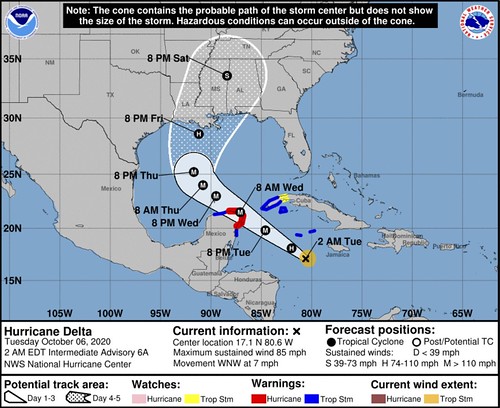
SUMMARY OF 200 AM EDT
LOCATION…17.1N 80.6W
ABOUT 165 MI…265 KM SSE OF GRAND CAYMAN
MAXIMUM SUSTAINED WINDS…85 MPH…140 KM/H
PRESENT MOVEMENT…WNW OR 300 DEGREES AT 7 MPH…11 KM/H
MINIMUM CENTRAL PRESSURE…974 MB…28.76 INCHES
FORECAST POSITIONS AND MAX WINDS
INIT 06/0300Z 16.8N 80.3W 70 KT 80 MPH
12H 06/1200Z 18.1N 82.0W 85 KT 100 MPH
24H 07/0000Z 19.8N 84.6W 100 KT 115 MPH
36H 07/1200Z 21.5N 87.1W 105 KT 120 MPH…INLAND
48H 08/0000Z 23.0N 89.5W 105 KT 120 MPH
60H 08/1200Z 24.0N 90.8W 105 KT 120 MPH
72H 09/0000Z 25.2N 91.7W 100 KT 115 MPH
96H 10/0000Z 28.6N 91.2W 85 KT 100 MPH
120H 11/0000Z 33.6N 88.4W 35 KT 40 MPH…INLAND
OUTLOOK
At 200 AM EDT (0600 UTC), the center of Hurricane Delta was located near latitude 17.1 North, longitude 80.6 West. Delta is moving toward the west-northwest near 7 mph (11 km/h). A faster northwestward motion is expected to start later today through Wednesday night. On the forecast track, the center of Delta is expected to pass southwest of the Cayman Islands this morning, and approach the northeastern portion of the Yucatan peninsula and the Yucatan Channel tonight. Delta is forecast to move over the southern Gulf of Mexico early Wednesday, and be over the south-central Gulf of Mexico late Wednesday and Thursday.
Data from an Air Force Reserve Hurricane Hunter aircraft indicate that the maximum sustained winds have increased to near 85 mph (140 km/h) with higher gusts. Additional rapid strengthening is forecast during the next day or so, and Delta is expected to be a major hurricane when it nears the Yucatan Peninsula.
Hurricane-force winds extend outward up to 10 miles (20 km) from the center and tropical-storm-force winds extend outward up to 70
miles (110 km).
The latest minimum central pressure reported by an Air Force Reserve Hurricane Hunter aircraft is 974 mb (28.76 inches).
TECHNICAL DISCUSSION
A few hours ago, data from the NOAA Hurricane Hunters supported upgrading Delta to a hurricane. Very recent reports from the Air Force Hurricane Hunters, who are currently in Delta, support increasing the intensity a little more to 70 kt. The minimum pressure has also decreased a few mb from the NOAA mission, and is now estimated to be 977 mb. Delta has strengthened at a rapid rate of 40 kt since genesis occurred just 24 hours ago. The hurricane is quite compact with a developing tight inner core, and even the tropical-storm-force winds extend only up to 60 n mi or so from the center.
After moving westward for much of the day, aircraft fixes from NOAA and the Air Force indicate that the hurricane has resumed a west-northwest motion, with the latest initial motion estimated to be 295/6 kt. Delta is expected to move to the northwest at a fairly quick pace on Tuesday and Wednesday as it moves in the flow between a subtropical high over the western Atlantic and Post-Tropical Cyclone Gamma over or near the Yucatan Peninsula. This motion should take Delta over or very near the northeastern portion of the Yucatan Peninsula by Tuesday night and over the southern Gulf of Mexico on Wednesday. After that time, the western part of the ridge
is expected to slowly erode as a trough moves eastward across the south-central U.S. This change in the steering pattern should cause Delta to slow down and then turn northward toward the northern Gulf coast, and it will likely make landfall there in a little more than 4 days. The models are in fair agreement, and the NHC track forecast is only a touch to the west of the previous one.
The hurricane has taken advantage of the near ideal conditions of low vertical wind shear, high amounts of moisture, and very warm 29-30 C SSTs. These favorable environmental conditions for the hurricane will persist for the next 2 or 3 days or so, and therefore, it seems reasonable to believe that rapid intensification will continue in the short term. Delta is expected to become a major hurricane in about 24 hours when it is near the Yuctan Peninsula. If Delta makes landfall on that landmass, it would likely temper the cyclone’s strength for a period of time. Beyond a few days, when Delta is forecast to approach the northern Gulf coast, there
will likely be an increase in southwesterly wind shear. These less conducive upper-level winds and cooler shelf waters should end the strengthening trend prior to the U.S. landfall. The NHC intensity forecast is largely an update of the previous one and lies close to the HCCA and IVCN consensus models.
Users are reminded to not focus on the details of the track or intensity forecasts, as the average 4-day track error is around 150 miles and the average 4-day intensity error is close to 15 mph.
KEY MESSAGES
1. Dangerous storm surge and hurricane conditions are expected within portions of the northern Yucatan Peninsula of Mexico beginning Tuesday night, and a Hurricane Warning is in effect.
2. Heavy rainfall will affect portions of Jamaica, the Cayman Islands, western Cuba and the northern Yucatan Peninsula during the next few days. This rainfall could lead to significant flash flooding and mudslides.
3. Tropical storm conditions are expected in portions of the Cayman Islands beginning early Tuesday, and a Tropical Storm Warning is in effect.
4. Delta is forecast to approach the northern Gulf Coast late this week as a hurricane. While there is large uncertainty in the track and intensity forecasts, there is an increasing risk of dangerous storm surge, wind, and rainfall hazards along the coast from Louisiana to the western Florida Panhandle beginning Thursday night or Friday. Residents in these areas should ensure they have their hurricane plan in place and monitor updates to the forecast of Delta.
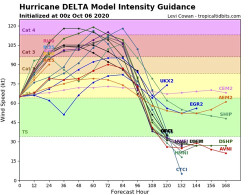
Model Data
Honestly, there hasn’t been much of a change in forecast track within the model data today, despite the extra data coming in from the national Hurricane Center. That is good news. It means the global models are handling the storm, and the surrounding environment, well.
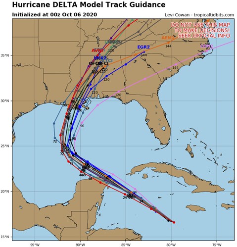
The track guidance shows a quick right turn and a bee-line for the northern Gulf Coast later this week.
Guidance is coming more in-line with a stronger storm entering the Gulf, but continues to show a weakening storm – though, one with a potentially large storm surge and larger wind field – moving ashore.
Bottom Line
Please keep up with the forecast in the coming days as Delta continues to move toward and then through the Gulf of Mexico.
Now is a good time to review your Hurricane Preparedness Kit. Make sure you have the supplies to last without power or water for three to seven days. Make sure you’ve got food, water and medical supplies (if needed).
And please – PLEASE! – keep checking back on the forecast as we move through this next week.


