Y’all. I get it. I’m tired of these things, too. If you think you’re getting tired of reading about the threat from a hurricane or tropical storm, you can’t imagine how I feel about writing about the threat for hurricanes and tropical storms.
When this season ends, I’m going to need two glasses of wine. You know, the types of “glasses of wine” you buy at the store that have a cork in the top. My goodness. Anyone else ready for, like, 70 and sunny?
From the NHC
SUMMARY OF 1000 AM CDT
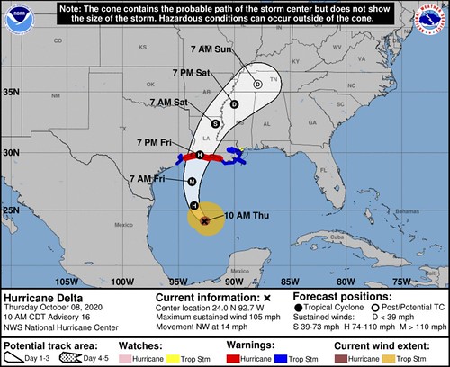
LOCATION…24.0N 92.7W
ABOUT 400 MI…645 KM S OF CAMERON LOUISIANA
MAXIMUM SUSTAINED WINDS…105 MPH…165 KM/H
PRESENT MOVEMENT…NW OR 310 DEGREES AT 14 MPH…22 KM/H
MINIMUM CENTRAL PRESSURE…968 MB…28.59 INCHES
FORECAST POSITIONS AND MAX WINDS
INIT 08/1500Z 24.0N 92.7W 90 KT 105 MPH
12H 09/0000Z 25.4N 93.6W 95 KT 110 MPH
24H 09/1200Z 27.5N 93.8W 100 KT 115 MPH
36H 10/0000Z 29.8N 93.1W 90 KT 105 MPH…ON THE COAST
48H 10/1200Z 32.4N 91.7W 45 KT 50 MPH…INLAND
60H 11/0000Z 34.0N 90.0W 30 KT 35 MPH…INLAND
72H 11/1200Z 35.6N 87.9W 20 KT 25 MPH…POST-TROP/REMNT LOW
96H 12/1200Z…DISSIPATED
DISCUSSION AND OUTLOOK
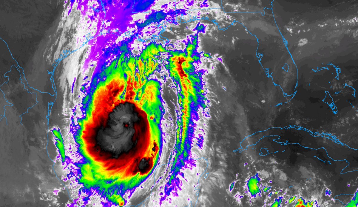
At 1000 AM CDT (1500 UTC), the center of Hurricane Delta was located near latitude 24.0 North, longitude 92.7 West. Delta is moving toward the northwest near 14 mph (22 km/h), and this motion with a reduction in forward speed is expected today. A turn toward the north is forecast to occur by late tonight, followed by a north-northeastward motion by Friday afternoon or Friday night. On the forecast track, the center of Delta will move over the central Gulf of Mexico today, over the northwestern Gulf of Mexico on Friday, and then move inland within the hurricane warning area Friday afternoon or Friday night.
Reports from NOAA and Air Force Reserve Hurricane Hunter aircraft indicate that maximum sustained winds have increased to near 105 mph (165 km/h) with higher gusts. Additional strengthening is forecast, and Delta is expected to become a major hurricane again by tonight. Some weakening is possible as Delta approaches the northern Gulf coast on Friday, with rapid weakening expected after the center moves inland.
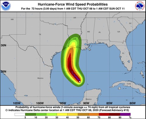
Hurricane-force winds extend outward up to 35 miles (55 km) from the center and tropical-storm-force winds extend outward up to 125 miles (205 km).
The latest minimum central pressure reported by the Hurricane Hunter aircraft is 968 mb (28.59 inches).
KEY MESSAGES
1. Life-threatening storm surge is expected near and east of where Delta makes landfall on Friday, and a Storm Surge Warning is in effect from High Island, Texas, to Ocean Springs, Mississippi. The highest inundation of 7 to 11 feet is expected somewhere between Rockefeller Wildlife Refuge and Port Fourchon, Louisiana. Residents in the warning area should promptly follow advice given by local officials. The storm surge risk remains high despite the forecast decrease in intensity before landfall since Delta is expected to
grow in size.
2. Hurricane-force winds are expected Friday afternoon and evening somewhere within the Hurricane Warning area between High Island, Texas, and Morgan City, Louisiana. Hurricane-force winds will also spread inland across portions of southern Louisiana near the path of Deltas center Friday evening and Friday night.
3. Significant flash flooding and minor to moderate river flooding are likely in parts of Louisiana Friday and Saturday, with additional flooding in portions of the central Gulf Coast into the Lower Mississippi Valley.
HAZARDS AFFECTING LAND
STORM SURGE: The combination of a dangerous storm surge and the tide will cause normally dry areas near the coast to be flooded by rising waters moving inland from the shoreline. The water could reach the following heights above ground somewhere in the indicated areas if the peak surge occurs at the time of high tide…
Rockefeller Wildlife Refuge, LA to Port Fourchon, LA including Vermilion Bay…7-11 ft
Holly Beach, LA to Rockefeller Wildlife Refuge, LA…4-7 ft
Port Fourchon, LA to the Mouth of the Mississippi River…4-6 ft
Sabine Pass to Holly Beach, LA…3-5 ft
Calcasieu Lake…3-5 ft
High Island, TX to Sabine Pass…2-4 ft
Mouth of the Mississippi River to Ocean Springs, MS…2-4 ft
Lake Borgne, Lake Pontchartrain, and Lake Maurepas…2-4 ft
Ocean Springs, MS to the AL/FL border including Mobile Bay…1-3 ft
Sabine Lake…1-3 ft
Port O’Connor, TX to High Island, TX including Galveston Bay… 1-3 ft
The deepest water will occur along the immediate coast near and to the east of the landfall location, where the surge will be accompanied by large and dangerous waves. Surge-related flooding depends on the relative timing of the surge and the tidal cycle, and can vary greatly over short distances. For information specific to your area, please see products issued by your local National Weather Service forecast office.
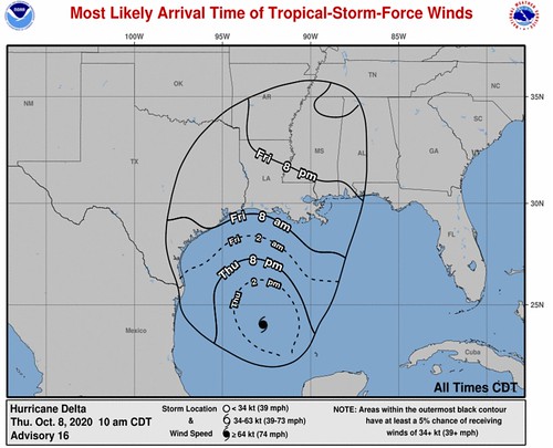
WIND: Hurricane conditions are expected within the hurricane warning area by Friday afternoon or evening, with tropical storm conditions expected within this area by early Friday. Tropical storm conditions are expected within the tropical storm warning areas on Friday, and are possible in the tropical storm watch area Friday night.
RAINFALL: Friday through Saturday, Delta is expected to produce 5 to 10 inches of rain, with isolated maximum totals of 15 inches, from southwest into south-central Louisiana. These rainfall amounts will lead to significant flash, urban, small stream flooding, along with minor to isolated moderate river flooding.
For extreme east Texas into northern Louisiana, southern Arkansas and western Mississippi, Delta is expected to produce 3 to 6 inches of rain, with isolated maximum totals of 10 inches. These rainfall amounts will lead to flash, urban, small stream and isolated minor river flooding.
As Delta moves farther inland, 1 to 3 inches of rain, with locally higher amounts, are expected in the Ohio Valley and Mid Atlantic this weekend.
TORNADOES: A few tornadoes are possible late tonight through Friday over southern parts of Louisiana and Mississippi
SURF: Swells from Delta will begin to affect portions of the northern and western Gulf coast later today. These swells are likely to cause life-threatening surf and rip current conditions. Please consult products from your local weather office.
TECHNICAL DISCUSSION
Satellite imagery shows that Delta is better organized this morning, with the center well embedded in a cold central dense overcast and a hint of a eye developing in the overcast. Reports from Air Force Reserve and NOAA Hurricane hunter aircraft indicate that the central pressure has fallen to 968 mb inside a 35 n mi wide eye, along with flight-level and SFMR winds that support an initial intensity of 90 kt.
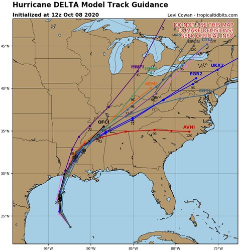
The initial motion remains northwestward or 305/12 kt. The track forecast is reasonably straightforward. During the next 12-24 h, Delta should turn to the north between a mid- to upper-level ridge over the Florida Peninsula and eastern Gulf of Mexico and a mid- to upper-level level trough over the U.S. Southern Plains. This should be followed by a north-northeastward motion that is expected to bring the center near or over the northern Gulf coast, most likely in southwestern Louisiana, in about 36 h. After landfall, the cyclone should move northeastward through the Lower Mississippi and Tennessee Valleys along the southern edge of the mid-latitude westerlies until it dissipates. The track guidance is very tightly clustered in terms of direction, and the new forecast track has only minor tweaks from the previous one.
Shear, sea surface temperature, and moisture conditions appear favorable for strengthening during the next 12-24 h or so, and based on this Delta is expected to regain major hurricane strength. Rapid intensification cannot be ruled out, although the various rapid intensification indices do not suggest a high chance, and the first 24 h of the forecast is already above the intensity guidance. The global models forecast strong southwesterly shear developing over the hurricane during the last 12 h before landfall, and based on this some weakening is forecast. Rapid weakening is expected after landfall, with Delta forecast to degenerate to a remnant low by 72 h and dissipate shortly after that. It should be noted that the NHC 1-2 day intensity forecasts are subject to errors
of around 1 Saffir-Simpson category.
Delta is expected to grow in size as it approaches the Louisiana coast. The NHC wind radii forecast again follows a consensus of the global and hurricane regional models.
Model data
The track guidance continues to sag a bit to the west. This is in response to the ridge of high pressure building into the Gulf from the west and the troughing to the north taking a bit longer to arrive (barely) and the areas of low pressure in Texas and MExico retrograding for a short time yesterday.
There is some data within the modeling that says Lake Charles as a low-to-medium chance for taking the northeastern eyewall of Delta. That would be devastating. Like many people who lived through Katrina, many of the people in Lake Charles still have tarps on their roofs and are still cleaning up from Laura in late August.
There is some good news, though, and bad news, too.
The good news is that model guidance continues to pull back on the top-end strength for Delta.
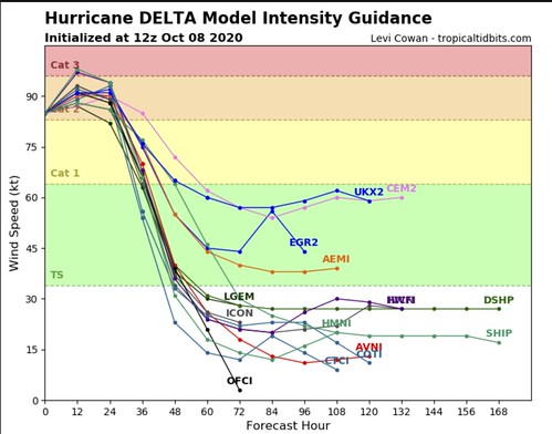
Most of the guidance shows a Category 2 Hurricane as the top-end for Delta. Still bad. But at least not a Category 4 or Category 5.
The bad news is that overnight Delta reorganized itself and as it begins to strengthen today, the wind field is already quite large with this storm. So even if it doesn’t roll into Lake Charles head on, there may still be Tropical Storm-force wind in Lake Charles. And that, for people with tarps on their roofs, is enough to make a mess of an already messy situation.
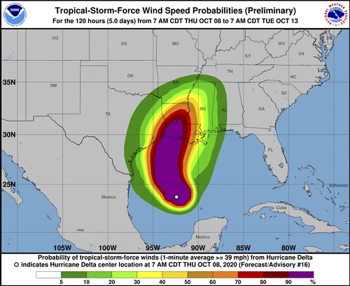
For others, particularly along the coast, this same strengthening and expanding on the wind field, expands the surge threat. The model guidance for inundations from NOAA shows places along the Louisiana coastline with 3ft-to-6ft and even up to 9ft of surge.
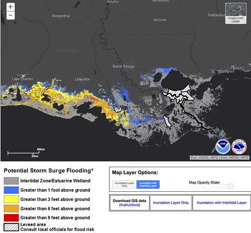
Along the Mississippi coastline, up to 3ft looks possible within the guidance.
Once Delta moves ashore, then the threat – for many places – turns into a heavy rain, wind gusts and tornado threat. And the tropical tornado threat, with this storm, may be higher than the rest of the storms this summer for a handful of reasons. Top one being the intrusion of dry air while landfall is occuring may help to increase instability on a small localized scale in areas with the background atmospheric capability of producing these brief and weak tornadoes.
Here is a look at the ECMWF model from Pivotal Weather for Saturday morning around 7am.
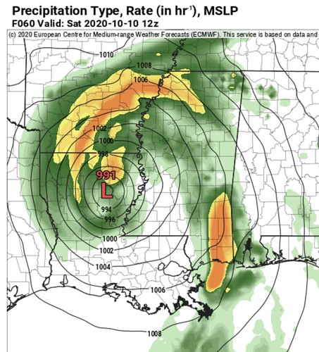
Notice the blob of orange across parts of southern Mississippi and southern Alabama. That would be one of the feeder bands capable of producing heavy rain, wind gusts up to 60mph and – potentially – tropical tornadoes.
Looking at what the data from the atmosphere, it shows dry air, instability and spin.
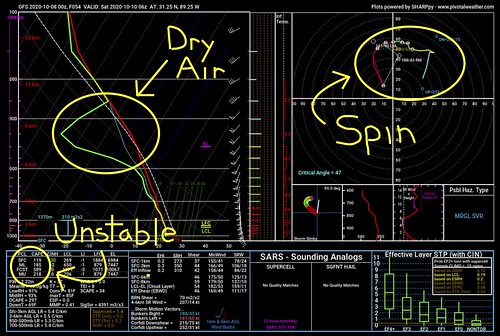
All things you need for tropical tornadoes.
South Mississippi impacts & Bottom Line
For those of you living in southern Mississippi, this will be more of a wind producer than a rainmaker. There will still be rain. In fact some spots across the Pine Belt will pick up as much as four inches of rain. Just nothing catastrophic.
It also won’t be “catastrophic” wind. But it will be breezy.
Timeline
Friday 4pm – 10pm: Passing showers, Wind gusts up to 30mph) as the first rainbands start to move through the area
Friday 10pm – Saturday 4am: Heavy rain at times, wind gusts up to 60mph, and the potential for brief tropical tornadoes west of I-59
Saturday 4am – Saturday 10am: Heavy rain at times, wind gusts up to 60mph and the potential for tropical tornadoes in all areas of south Mississippi
Saturday 10am – 4pm: Heavy rain at times, wind gusts up to 40mph and the potential for tropical tornadoes east of I-59
Saturday 4pm – 10pm: Mostly cloudy, wind gusts up to 30mph, drying out
Expectations
– There will be some localized flooding, with water coming up in people’s yards and the creeks may rise a bit for a short period of time during some of the heavy rain within the rainbands.
– Power outages will be likely. Prepare to be without power for up to 6 to 12 hours. The combination of a constant breeze and higher gusts as well as some of the rain means trees are likely to come down. On top of that, tropical tornadoes will be possible within some of the rainbands.
– Based on the latest available data, this will not be a widespread catastrophic event for our area. But a some places will still see damage from gusty wind, downed trees and possible tornadoes.
Tornado Threat
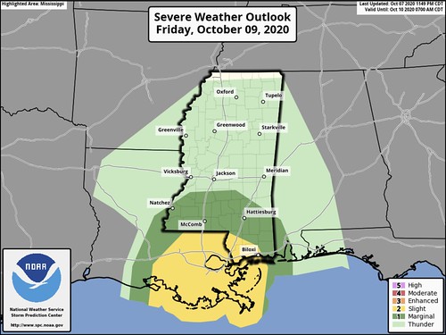
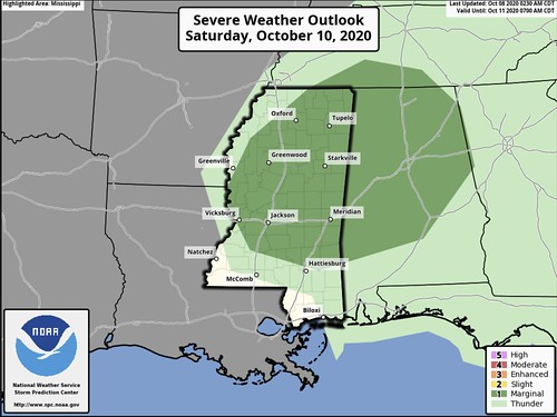
The SPC has pegged southern Mississippi with a Marginal Risk for severe weather on Friday. And into parts of Saturday, too.
Bottom Line
This isn’t going to be a catastrophic event for everyone. Since this storm is moving inland across Louisiana, our main concern is for the batches of heavy rain, gutsy wind and the potential for tornadoes. Prepare to be without power for up to 12 hours as trees will likely be blown down with some of the stronger wind gusts, and keep an eye on low-lying areas while the heavy rain moves through as localized short-term flooding may be possible.
This will start to move through Friday night and be out of the area by Saturday night. So it shouldn’t be a long-term event.
Hang in there, get prepared, and we will be enjoying much better – and calmer – weather by next week.


