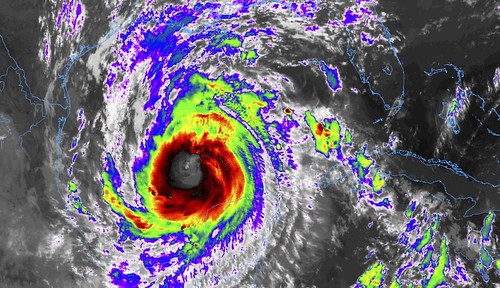
Hurricane Delta is in, what I’ve often called, a “primo environment.” That is to say, it has warm water and low shear, so it is free to organize and strengthen without predictable physics getting in the way.
The no-longer-Category-4 Hurricane may be a “shell” of its former self in terms of top-end wind speed, but it has gained a lot of girth since making landfall across the Yucatan peninsula. Tropical-storm-force wind now extends more than 100 miles from the center. And the Hurricane is more than 300 miles across.
From the NHC
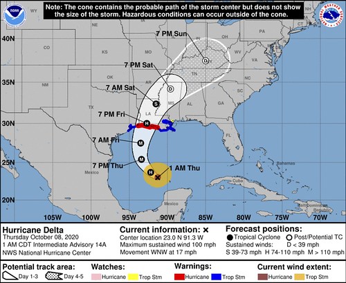
SUMMARY OF 100 AM CDT
LOCATION…23.0N 91.3W
ABOUT 485 MI…780 KM SSE OF CAMERON LOUISIANA
MAXIMUM SUSTAINED WINDS…100 MPH…155 KM/H
PRESENT MOVEMENT…WNW OR 300 DEGREES AT 17 MPH…28 KM/H
MINIMUM CENTRAL PRESSURE…973 MB…28.73 INCHES
FORECAST POSITIONS AND MAX WINDS
INIT 08/0300Z 22.5N 90.9W 80 KT 90 MPH
12H 08/1200Z 23.7N 92.2W 95 KT 110 MPH
24H 09/0000Z 25.4N 93.4W 105 KT 120 MPH
36H 09/1200Z 27.5N 93.5W 100 KT 115 MPH
48H 10/0000Z 30.0N 92.7W 85 KT 100 MPH
60H 10/1200Z 32.4N 91.5W 35 KT 40 MPH…INLAND
72H 11/0000Z 34.2N 89.6W 20 KT 25 MPH…POST-TROP/REMNT LOW
96H 12/0000Z 37.5N 85.0W 20 KT 25 MPH…POST-TROP/REMNT LOW
120H 13/0000Z…DISSIPATED
OUTLOOK
At 100 AM CDT (0600 UTC), the center of Hurricane Delta was located near latitude 23.0 North, longitude 91.3 West. Delta is moving toward the west-northwest near 17 mph (28 km/h). A northwestward motion with a reduction in forward speed is expected during the next several hours. A turn to the north is forecast to occur tonight followed by a north-northeastward motion on Friday and Friday night. On the forecast track, the center of Delta will move over the central Gulf of Mexico today, and approach the northern Gulf coast on Friday. Delta is forecast to move inland within the hurricane warning area by late Friday or Friday night.
Maximum sustained winds are near 100 mph (155 km/h) with higher gusts. Additional strengthening is forecast, and Delta is expected to become a major hurricane again by tonight or early Friday. Some weakening is forecast as Delta approaches the northern Gulf coast by late Friday.
Hurricane-force winds extend outward up to 35 miles (55 km) from the center and tropical-storm-force winds extend outward up to 140 miles (220 km).
The estimated minimum central pressure based on data from the Air Force Hurricane Hunters is 973 mb (28.73 inches).
HAZARDS AFFECTING LAND
STORM SURGE: The combination of a dangerous storm surge and the tide will cause normally dry areas near the coast to be flooded by rising waters moving inland from the shoreline. The water could reach the following heights above ground somewhere in the indicated areas if the peak surge occurs at the time of high tide…
Pecan Island to Port Fourchon, LA including Vermilion Bay…7-11 ft
Cameron, LA to Pecan Island, LA…4-7 ft
Port Fourchon, LA to the Mouth of the Mississippi River…4-6 ft
Mouth of the Mississippi River to Ocean Springs, MS…3-5 ft
Lake Borgne, Lake Pontchartrain, and Lake Maurepas…3-5 ft
Ocean Springs, MS to MS/AL border…2-4 ft
High Island, TX to Cameron, LA including Calcasieu Lake…2-4 ft
MS/AL border to the AL/FL border including Mobile Bay…1-3 ft
Sabine Lake…1-3 ft
Port O’Connor, TX to High Island, TX including Galveston Bay…1-3 ft
The deepest water will occur along the immediate coast near and to the east of the landfall location, where the surge will be accompanied by large and dangerous waves. Surge-related flooding depends on the relative timing of the surge and the tidal cycle, and can vary greatly over short distances. For information specific to your area, please see products issued by your local National Weather Service forecast office.
WIND: Hurricane conditions are expected within the hurricane warning area by Friday evening, with tropical storm conditions expected within this area earlier on Friday. Tropical storm conditions are expected within the tropical storm warning areas on Friday.
RAINFALL: Delta is expected to produce an additional 1 to 3 inches of rain over the far northwestern Yucatan Peninsula through early Thursday. The additional rainfall may still result in areas of significant flash flooding.
Friday through Saturday, Delta is expected to produce 4 to 8 inches of rain, with isolated maximum totals of 12 inches across portions of the central Gulf Coast north into portions of the Lower to Middle Mississippi Valley. These rainfall amounts will lead to flash, urban, small stream and minor to isolated moderate river flooding. As Delta moves farther inland, 1 to 3 inches of rain, with locally higher amounts, is expected in the Ohio Valley and Mid Atlantic this weekend.
TORNADOES: The risk of a few tornadoes will increase late tonight into Friday over portions of southern Louisiana, southern Mississippi, and southwest Alabama.
SURF: Swells from Delta will begin to affect portions of the northern and western Gulf coast later today. These swells are likely to cause life-threatening surf and rip current conditions. Please consult products from your local weather office.
TECHNICAL DISCUSSION
Observations from an Air Force Reserve Unit Hurricane Hunter aircraft indicate that Delta is gradually strengthening while it moves over the open waters of the south-central Gulf of Mexico. Based on a blend of adjusted flight-level and SFMR wind measurements from the plane, the current intensity is set at 80 kt. The cloud pattern of the hurricane continues to become better organized on satellite images, with a growing Central Dense Overcast, and convective banding features becoming better defined, particularly over the northern semicircle of the circulation. Additional intensification is likely while Delta moves through a
favorable environment during the next day or so, and the official forecast is fairly close to the corrected consensus guidance, HCCA. When the system moves into the northern Gulf, a decrease in oceanic heat content, drier mid-tropospheric air, and increased vertical shear should cause at least slow weakening. The NHC intensity forecast is above the numerical guidance in 36-48 hours. It should be noted that 1-2 day tropical cyclone intensity forecasts are subject to errors of around 1 Saffir-Simpson category.
The global models show a further increase in the size of the hurricane while it moves into the northern Gulf. The official wind radii forecasts are based on a consensus of these model predictions.
The latest center fixes from the Hurricane Hunters show a west-northwestward motion, at about 300/15 kt. Delta should turn toward the north-northwest and north over the next 36 hours or so while moving around the western periphery of a subtropical high pressure system centered over Florida. When the hurricane moves into the northern Gulf of Mexico on Friday, Delta should turn toward the north-northeast on the southeastern side of a mid-tropospheric shortwave over the southern United States. The official track forecast is close to both the simple and corrected dynamical model consensus predictions, TVCA and HCCA, respectively. These objective aids are in close agreement with one another.
Based on the official forecast, it is time to issue storm surge and hurricane warnings for a portion of the northern Gulf of Mexico coast.
Model Data
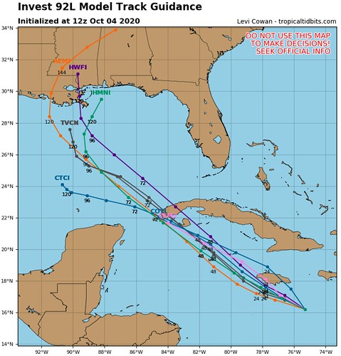
It has been interesting to watch how the extra data collected from the Hurricane Hunters has changed the model suggestions for track and intensity. This is why the Hurricane Hunters are an invaluable resource during hurricane season. Think back! Prior to the collection of atmoaphseric databy the Hurricane Hunters, the model data showed this:
Now, after a few days of round-the-clock data collection, the data shows this:
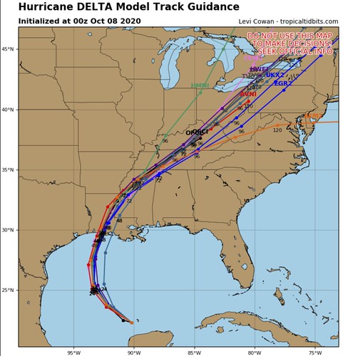
Much better.
Along the same lines, the model data showing the intensity guidance is in pretty decent agreement, too.
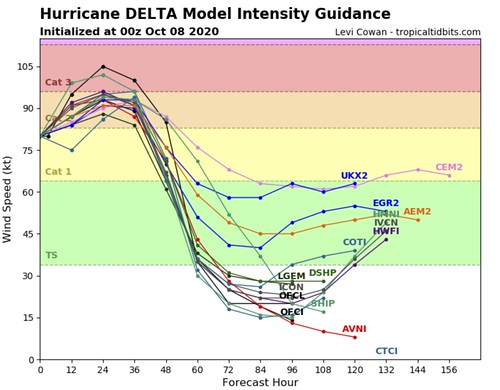
This is giving all of the meteorologists a good idea about what will eventually happen with Delta.
Tropical Update from earlier
While this was posted around 4pm Wednesday, there is still a lot of info in here that is still relevant.
Local impacts for So. Miss./h2>
For those of you living in southern Mississippi, this will be more of a wind producer than a rainmaker. There will still be rain. In fact some spots across the Pine Belt will pick up as much as four inches of rain. Just nothing catastrophic.
It also won’t be “catastrophic” wind. But it will be breezy.
Timeline
Friday PM: Wind starts to pick up (gusts up to 30mph) and the first rainbands start to move through the area
Friday overnight: Heavy rain at times, wind gusts up to 60mph, and the potential for brief tropical tornadoes
Saturday AM: Heavy rain at times, wind gusts up to 40mph as the last rainbands move through the area
Saturday PM: Mostly cloudy and breezy (gusts up to 30mph)
Expectations
– There will be some localized flooding, with water coming up in people’s yards and the creeks may rise a bit for a short period of time during some of the heavy rain within the rainbands.
– Power outages will be likely. Prepare to be without power for up to 6 to 12 hours. The combination of a constant breeze and higher gusts as well as some of the rain means trees are likely to come down. On top of that, tropical tornadoes will be possible within some of the rainbands.
– Based on the latest available data, this will not be a widespread catastrophic event for our area. But a some places will still see damage from gusty wind, downed trees and possible tornadoes.
Tornado Threat
The SPC has pegged southern Mississippi with a Marginal Risk for severe weather on Friday. And this may be extended into parts of Saturday, too.

For comparison, here is the Karrie Meter for overnight Friday and into Saturday morning:
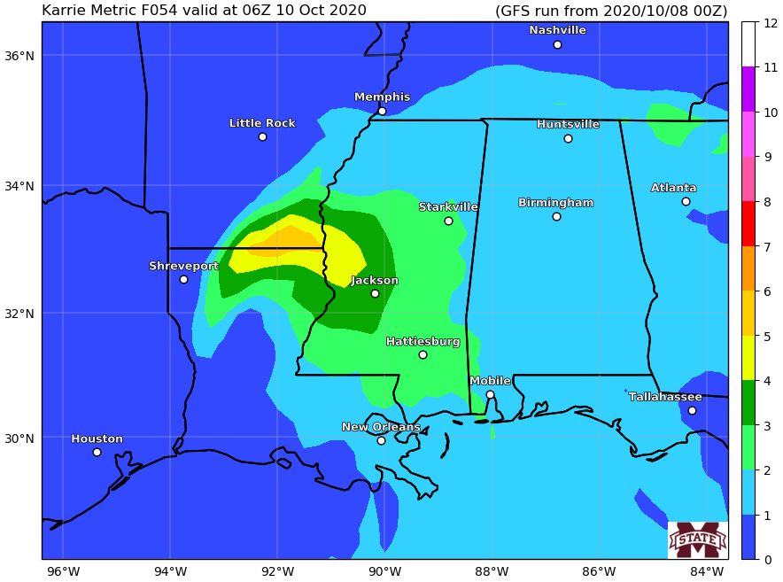
Full disclosure, I don’t think the Karrie Meter is terribly useful for land-falling tropical systems. However, you can’t know until you try. So we are going to give it a shot. With a land-falling tropical system, the threshold to create a tornado is a bit different. So, I would hypothesize that the threshold is much lower of the Karrie Meter. So places with 1s and 2s may still present a problem, even when regularly, they may not.
We will have to wait and see!


