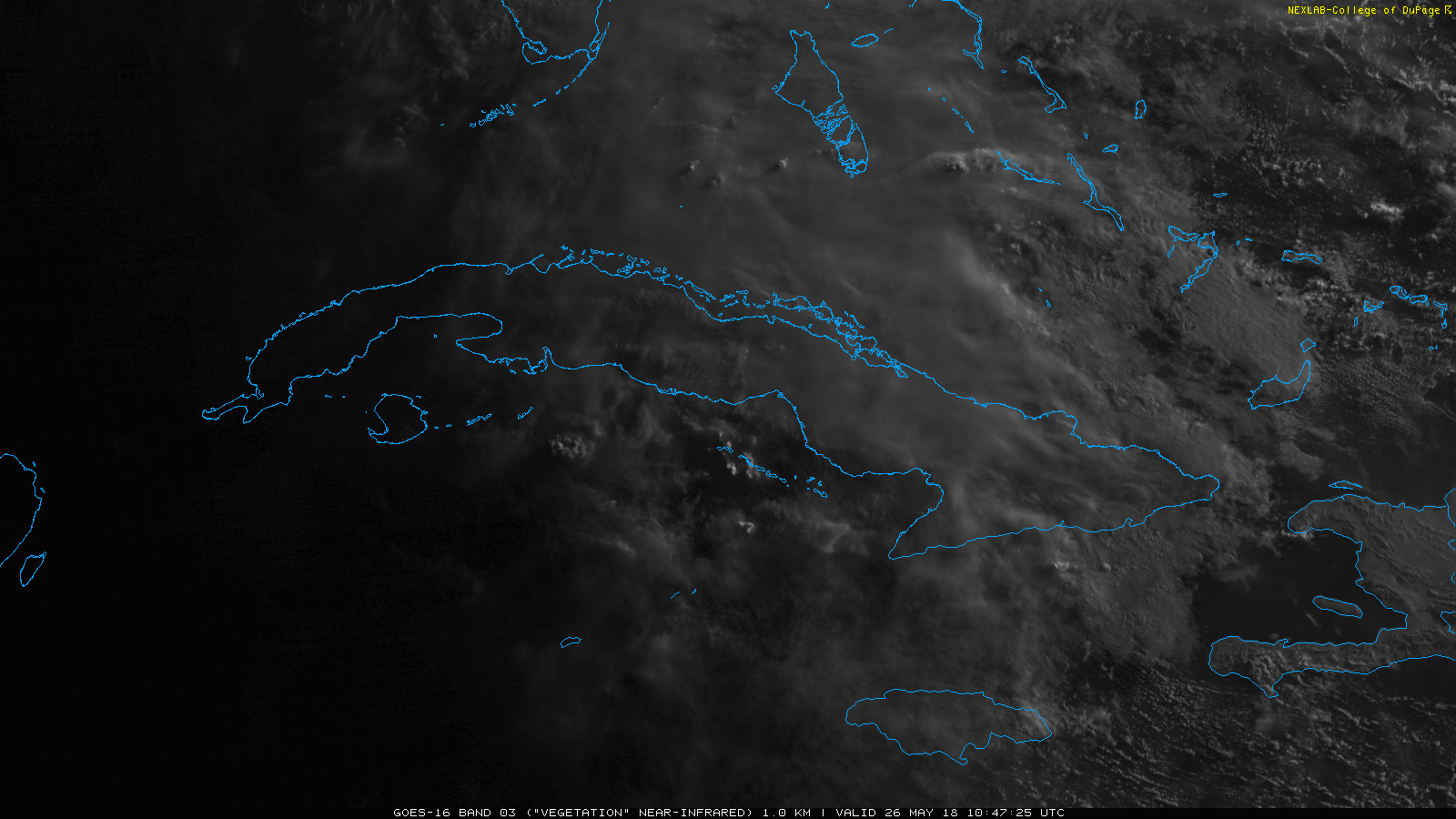
Subtropical Storm Alberto continues to look pretty ragged and disorganized. However there are signs that is it trying to get its act together. The warmer waters of the NW Caribbean are helping with the development of extra storms on the systems east side, but it is still struggling to develop a ring of storms around the centralized area of low pressure. As the system – as a whole – begins to trek northward a bit faster, storms should begin to wrap a bit closer to the center.
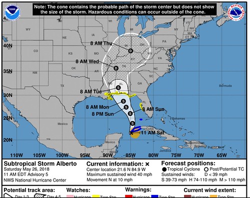
Forecast models have continued to wiggle the forecast track to the east a bit. Here is a look at the official forecast track from the National Hurricane Center:
Nerd Alert!
The ragged look and disorganization is normal according to research. It isn’t uncommon with storms birthed from the Central American Gyre to be weighted heavily to one side. Philippe Papin has done a great job explaining this during the last few days on twitter.
Currently #STC #Alberto has a very broad circulation more akin to a Central American Gyre (#CAG). However, my Central American Gyre (#CAG) diagnostics indicate Alberto’s broad wind field should contract in size over the next 24-36h while moving into the #GoM. CAG->TC evolution pic.twitter.com/OcTzekQxll
— Philippe Papin (@pppapin) May 25, 2018
Some structural changes beginning with #STC #Alberto this morning. While convection is still asymmetric, it is firing closer to the center as it begins accelerating NE. Should help to tighten its vortex as it gets pulled over #Cuba or a new center may form within the convection. pic.twitter.com/ck1wOFjo9f
— Philippe Papin (@pppapin) May 26, 2018
Here is the latest detailed forecast discussion from the National Hurricane Center:
Subtropical Storm Alberto Discussion Number 5
NWS National Hurricane Center Miami FL AL012018
1100 AM EDT Sat May 26 2018There has been an increase in convection to the east and southeast of the center of Alberto this morning, however, the overall organization of the system has not changed much. Visible satellite imagery and recent reconnaissance aircraft data suggest that the circulation is somewhat elongated and a new low-level center could be forming just northwest of the western tip of Cuba. As suggested by the global models there could be several re-formations of or a discontinuity in the track of the low-level center today. Although there have been no recent observations to support the 35-kt intensity, the intensity is held at that value since the aircraft has not sampled the area well east of the center and due to the overall increase in convection.
A shortwave trough dropping southeastward over the northwestern Gulf of Mexico is expected to sharpen the larger negatively tilted trough over the eastern Gulf, which is expected to cause the cyclone to deepen during the next 24 to 36 hours. This trend is consistent with the global model guidance which unanimously strengthen Alberto through Sunday. After that time, Alberto is expected to be co-located with the upper-level low which should result in some decrease in shear and a possible transition to a more tropical cyclone-like structure. The NHC intensity forecast calls for steady strengthening, but only the ECMWF-based SHIPS guidance brings Alberto near hurricane strength before landfall. Steady weakening should occur after the center moves inland.
Alberto is moving northward to north-northeastward at about 9 kt. The cyclone should continue on this general heading today, but it is expected to turn north-northwestward and slow down on Sunday and Sunday night as it interacts with the mid- to upper-level trough/low over the Gulf. The track guidance has shifted slightly eastward this cycle and the NHC forecast has been adjusted accordingly. The new NHC track is near a blend of the ECMWF and GFS models, but it is not as far east as the UKMET or the TVCA
multi-model consensus. The eastward adjustment in the track forecast has required the issuance of a tropical storm watch for a portion of the west coast of Florida and an eastward nudge of the watch along the coast of the Florida panhandle.KEY MESSAGES:
1. Regardless of its exact track and intensity, Alberto is expected to produce heavy rainfall and flash flooding over western Cuba, southern Florida and the Florida Keys. Rainfall and flooding potential will increase across the central U.S. Gulf Coast region and over much of the southeastern United States beginning Sunday and will continue into next week.
2. Tropical-storm-force winds and hazardous storm surge are possible along portions of the central and eastern U.S. Gulf Coast beginning on Sunday, including areas well east of the track of Alberto’s center, and tropical storm and storm surge watches are in effect for portions of these areas. Residents in the watch areas are encouraged not to focus on the details of the forecast track of Alberto and should follow any guidance given by their local government officials.
3. Dangerous surf and rip current conditions are affecting portions of the Yucatan Peninsula and western Cuba and will likely spread along the eastern and central U.S. Gulf Coast later today and tonight.
FORECAST POSITIONS AND MAX WINDS
INIT 26/1500Z 21.6N 84.9W 35 KT 40 MPH
12H 27/0000Z 23.8N 84.6W 40 KT 45 MPH
24H 27/1200Z 26.0N 85.1W 45 KT 50 MPH
36H 28/0000Z 27.4N 86.0W 50 KT 60 MPH…TROPICAL CYCLONE
48H 28/1200Z 28.7N 86.6W 55 KT 65 MPH…TROPICAL CYCLONE
72H 29/1200Z 31.6N 87.7W 40 KT 45 MPH…INLAND
96H 30/1200Z 35.6N 88.2W 25 KT 30 MPH…INLAND
120H 31/1200Z 39.0N 85.0W 20 KT 25 MPH…INLAND
So, like Nick, that’s great and all… But what does all of this mean?
Main Concerns: Heavy rainfall, tropical storm-force wind (39-73mph), storm surge along the east side of the storm, and dangerous rip currents along the LaAlaMiss coast. Because the storm is weighted to the east side, most of the worst impacts will be ont he east side of the system.
Louisiana: The latest forecast model trends as well as the official forecast continue to push this storm away from you (for now). Given the latest forecast puts this area on the far west side of the storm, the main concerns here will be some rain and wind (1″ to 3″ of rain ; up to 40mph wind) but – given the forecast cone – it would be the least affected by the brunt of this storm.
Mississippi: Mississippi is going to be bisected by a sharp contrast in conditions as Alberto moves through. Over the course of as little as 100 miles from west-to-east the rainfall totals may go from 1″ of rain to 10″ (depending on the track). Look for heavy rain (up to 10″ in some spots – in the east column of counties – possible), tropical storm force wind (up to 65mph possible near the cost, but lower inland), flash flooding, and trees down due to the rain and wind. It looks liek most inland counties of southern Mississippi will see between 2″ and 6″ of rain with winds between 20mph and 40mph with gusts to 50mph. Further inland the wind threat diminishes north of I-20.
Alabama: Looks to get the worst of the three states. Look for heavy rain, flash flooding, tree damage, and storm surge along the coast. Wind speeds along the coast will reach up to 65mph. Rainfall totals will be ebtween 6″ and 10″ south of I-65, and storm surge of 2 to 4 feet will be possible along the coast.
Cool, I know what it means… But now what do I do?
Check over your Hurricane Preparedness Kit. Make sure you have everything you need to live for a few days without power or water. This may not be a Category 5 Hurricane, but with all of the rain that is forecast plus a bit of wind, there may be power outages due to trees coming down. And all of the rain could back-up water and sewer systems, leaving you without water.
Prepare to survive for – at least – three days without power and water.
So, could any of this change.. Or is it locked in?
This can still change. Forecasts to tropical systems are inherently difficult because these system aren’t riding along the jet stream like regular storm systems that we deal with during the rest of the year. Because there isn’t a strong current steering them, it is difficult to know – exactly – where they will go.
Because it is tough to know – exactly – where these systems will go, it is difficult to know -exactly – how strong they will become. Since tropical systems use the warm waters of the ocean and Gulf of Mexico as fuel, their strength is tied directly to their path of the water. Will it move over warmer water? Will it move over cooler water? While we have a very good estimate for the forecast track, even a little wiggle (moving the storm over warmer water, for example) can have a drastic impact on how strong the system will become.
Ocean temperature not only at the surface, but also at depth is very important, too.
FORECAST TRACK
The forecast track has been handled pretty while by a few of the models. The UKMET and ECMWF have done well with it. The GFS has struggled quite a bit.
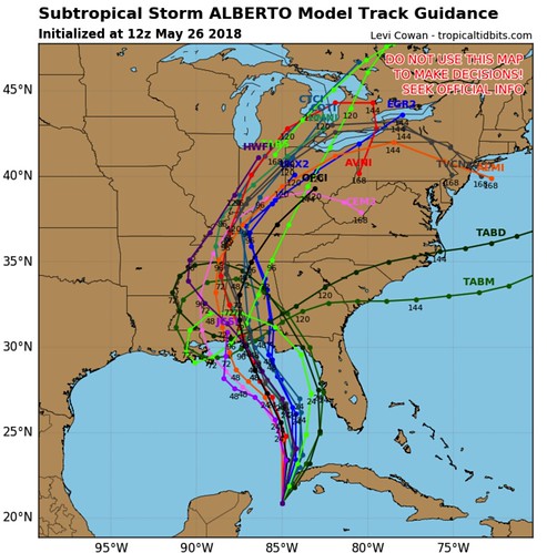
The models continue to stay in decent agreement that the storm will move north-northeast into the Gulf of Mexico before peeling back to the northwest toward Mississippi and Alabama. Most models then take it back to the northeast is it gets picked up by the jet stream. This may shift a bit – in either direction – depending on the arreas of high pressure out there steering it. Lately the trend has been a shift further east toward Florida as it enters the Gulf and thus may pull the storm a bit further east as it gets closer to Mississippi and Alabama.
Some models actually have it to a loop before being pulled to the east. This is because Alberto is going ot be moving between two competing ridges of high pressure. As one strengthens, it tends to tug a bit harder than the other – and vice-versa. That game of tug-of-war ends up pulling the system (in the models, only, not in the official forecast) around in a loop.
That is an unlikely scenario, but not impossible.
FORECAST STRENGTH
This is where meteorologists and the models tend to have the toughest time. I have no problem recognizing my own limitations, as well as our computers. Forecasts for strength going out 48 hours are actually pretty good by the meteorologists at the National Hurricane Center. Once you get to 72 hours, they are still good, but not perfect. Beyond that, though, sometimes it can get difficult.
in this case it becomes a bit more difficult since the storm is currently subtropical and not fully tropical. And it is expected to transition – at some point – during its journey across the Gulf.
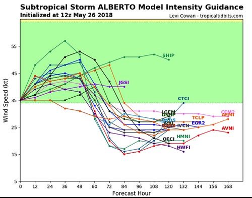
The model data keeps it as a tropical storm. The official forecast keeps it as a tropical storm.
There may be wiggle room, here, but there won’t be much. The waters int he Gulf aren’t quite warm enough to worry about “rapid intensification” nor sustaining a major hurricane. But the strength of the system could change a bit, perhaps a weak Category 1 hurricane at landfall as opposed to a strong Tropical Storm. Though, conversly, if it never gets away from the shear it is dealing with, it may move ashore as a weaker Tropical Storm, too.
WATER TEMPERATURES
The water temperature may not change much, but it will change what happens with the storm itself.
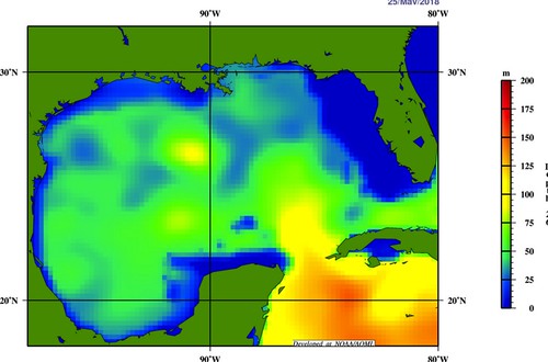
The current track takes the system over water that isn’t as warm at depths of 50 to 100 meters. That means as it rains on the ocean surface, the water that moves up to replace the rain-cooled water that sinks won’t be as warm. Water that isn’t as warm doesn’t provide as much energy for the storm to use.
The Bottom Line
Here are the key messages for #Alberto as of 10 am CDT/11am EDT. Heavy rains and flash flooding over western Cuba and southern Florida will continue today. Tropical Storm conditions could reach the northern Gulf Coast as early as Sunday evening. https://t.co/tW4KeGdBFb pic.twitter.com/hdOmShnh4m
— NHC Atlantic Ops (@NHC_Atlantic) May 26, 2018
If you are in the forecast cone for Alberto you should be making preparations to be directly affected by this storm.
SUMMARY OF WATCHES AND WARNINGS IN EFFECT:
A Storm Surge Watch is in effect for…
* Crystal River to the Mouth of the Mississippi River
A Tropical Storm Warning is in effect for…
* Cuban province of Pinar del Rio
* Dry Tortugas
A Tropical Storm Watch is in effect for…
* Boca Grande to Anclote River
* Aucilla River to Grand Isle
* Lake Pontchartrain and Lake Maurepas
A Storm Surge Watch means there is a possibility of life-threatening inundation, from rising water moving inland from the coastline, in the indicated locations during the next 48 hours. For a depiction of areas at risk, please see the National Weather Service Storm Surge Watch/Warning Graphic, available at hurricanes.gov.
A Tropical Storm Warning means that tropical storm conditions are expected somewhere within the warning area, in this case within the next 24 hours.
A Tropical Storm Watch means that tropical storm conditions are possible in the United States portion of that watch area within 48 hours.
For storm information specific to your area in the United States, including possible inland watches and warnings, please monitor products issued by your local National Weather Service forecast office. For storm information specific to your area outside the United States, please monitor products issued by your national
meteorological service.


