10AM Advisory from the National Hurricane Center:
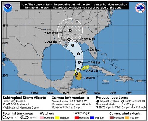
The National Hurricane Center just released forecast track information for Subtropical Storm Alberto. Here is the forecast discussion as of 10AM:
Subtropical Storm Alberto Discussion Number 1
NWS National Hurricane Center Miami FL AL012018
1000 AM CDT Fri May 25 2018The broad low pressure system that the NHC has been tracking for the past several days over the Yucatan Peninsula has finally moved offshore over the waters of the northwestern Caribbean Sea. Although the system possesses multiple low-level circulations, the overall larger circulation has improved since yesterday. Given that the system has been interacting with a sharp upper-level trough, the strongly sheared low has been designated a subtropical storm. The initial intensity is based on buoy and ship observations of 30-35 kt. Ship 3ETA7 located just northeast of the center at 1100Z reported 45-kt winds at 50 meters elevation. Those winds equate to 35-40 kt at 10 meters elevation. An Air Force Reserve Hurricane Hunter Aircraft is scheduled to investigate Alberto later this afternoon and provide more information on the storm’s structure and intensity.
The initial motion estimate is an uncertain 020/05 kt. The broad inner-core wind field and multiple swirls makes the short-term motion forecast a little tricky. However, a large subtropical ridge to the east should generally induce a slow north to north-northeastward motion for the next 24 hours or so. After that, the ridge across the western Atlantic and Florida, along with a mid/upper-level low forecast to develop over the central Gulf of Mexico, should result in a faster northward motion at 36-48 hours, followed by a gradual turn toward the northwest around the northern fringe of the aforementioned mid/upper-level low. By 96 hours, the cyclone is forecast to slow down significantly as it nears the north-central Gulf Coast due to a large weakness in the subtropical ridge forecast to develop over the Deep South. The official forecast track closely follows the consensus models TVCN
and HCCA.Given the broad inner-core wind field and belligerent westerly wind shear forecast to persist for the next 48 hours or so, only gradual intensification is expected. By 72 hours, however, when the cyclone is forecast to move slowly over above-normal SSTs of 28-29C and into an upper-level col and weak wind shear, some additional strengthening could occur. For now, the intensity forecast will remain conservative due to possible intrusion of dry mid-level air before landfall, and closely follows the HCCA consensus model.
KEY MESSAGES:
1. Regardless of its exact track and intensity, Alberto is expected to produce heavy rainfall and flash flooding over the northeastern Yucatan Peninsula of Mexico, western Cuba, southern Florida and the Florida Keys. Rainfall and flooding potential will increase across the central Gulf Coast region and the southeastern United States later this weekend and early next week when Alberto is expected to slow down after it moves inland.
2. Alberto could bring tropical storm conditions and storm surge to portions of the central and eastern Gulf Coast later this weekend and early next week, although it is too soon to specify the exact location and magnitude of these impacts. Residents in these areas should monitor the progress of Alberto, as tropical storm and storm surge watches may be required later today or tonight.
3. Dangerous surf and rip current conditions are affecting portions of the Yucatan Peninsula and western Cuba and will likely spread along the eastern and central U.S. Gulf Coast later this weekend.
FORECAST POSITIONS AND MAX WINDS
INIT 25/1500Z 19.7N 86.8W 35 KT 40 MPH
12H 26/0000Z 20.5N 86.6W 35 KT 40 MPH
24H 26/1200Z 22.0N 86.2W 40 KT 45 MPH
36H 27/0000Z 24.1N 85.8W 45 KT 50 MPH
48H 27/1200Z 26.7N 86.1W 50 KT 60 MPH
72H 28/1200Z 29.3N 87.9W 55 KT 65 MPH
96H 29/1200Z 31.0N 89.1W 30 KT 35 MPH…INLAND
120H 30/1200Z 33.6N 88.7W 20 KT 25 MPH…INLAND
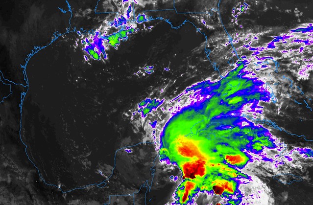
This is how is looks on satellite imagery this morning:
NHC will initiate advisories at 11 AM EDT / 10 AM CDT on Subtropical Storm Alberto located over the northwestern Caribbean Sea.
— NHC Atlantic Ops (@NHC_Atlantic) May 25, 2018
The national Hurricane Center tweeted that as of 10AM CDT forecasters would be referring to Invest 90L as “Subtropical Storm Alberto” going forward. While “Subtropical storm” isn’t on “what does tropical development mean” page, here is a quick explanation:
From the National Hurricane Center:
A non-frontal low-pressure system that has characteristics of both tropical and extratropical cyclones. Like tropical cyclones, they are non-frontal, synoptic-scale cyclones that originate over tropical or subtropical waters, and have a closed surface wind circulation about a well-defined center. In addition, they have organized moderate to deep convection, but lack a central dense overcast. Unlike tropical cyclones, subtropical cyclones derive a significant proportion of their energy from baroclinic sources, and are generally cold-core in the upper troposphere, often being associated with an upper-level low or trough. In comparison to tropical cyclones, these systems generally have a radius of maximum winds occurring relatively far from the center (usually greater than 60 n mi), and generally have a less symmetric wind field and distribution of convection.
Subtropical storms can gain tropical characteristics and eventually be just a tropical storm. But for now, Alberto is a subtropical storm. The Hurricane Hunters have been dispatched to investigate the storm and will be flying through it later this afternoon. Currently the system appears a bit less organized on satellite and the Hurricane Hunters will be flying through to get a better idea about the characteristics of the storm.
North of #Alberto‘s low-level center, mid-level westerly flow exists, suggesting that the mid-level center is somewhere near the convection to the NE. This may foreshadow a center-jump later.
Practically, this is expected, and is just the next step in the storm’s organization. pic.twitter.com/WrDKYgnet4
— Levi Cowan (@TropicalTidbits) May 25, 2018
Here is the 7AM discussion from the National Hurricane Center:
For the North Atlantic…Caribbean Sea and the Gulf of Mexico:
1. Satellite images and surface observations indicate that the low pressure system located over the northwestern Caribbean Sea just east of the Yucatan Peninsula of Mexico has become better defined overnight, and thunderstorm activity has also increased and become better organized. Environmental conditions are forecast to steadily become more conducive for development, and a subtropical or tropical depression or storm is likely to form by Saturday over the northwestern Caribbean Sea or the southeastern Gulf of Mexico. An Air Force Reserve reconnaissance aircraft is scheduled to investigate the low this afternoon.
Locally heavy rainfall is forecast across western Cuba and over much of Florida and the northern Gulf Coast into early next week. This system could also bring tropical-storm-force winds and storm surge to portions of the northern Gulf Coast by late this weekend or early next week. In addition, the threat of rip currents will steadily increase along the Gulf Coast from Florida westward to Louisiana over the Memorial Day weekend. For more information on these threats, please see products issued by your local weather office, and see High Seas Forecasts issued by the National Weather Service for information on gale warnings associated with this system. The next Special Tropical Weather Outlook on this system will be issued by 200 PM EDT today.
* Formation chance through 48 hours…high…90 percent.
* Formation chance through 5 days…high…90 percent.
Right now, forecast models show Alberto moving north across the Gulf of Mexico and toward the northern Gulf Coast.
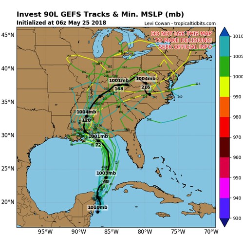
But due to the nature of the storm, most of the impacts will be felt on the east side of this system.
Simulated satellite imagery (ECMWF 00z) shows the asymmetric structure (wind shear, dry air, front) of #Alberto continuing for 2-3 days, before the system ditches the front & becomes fully tropical at about 990 mb central pressure — 60-70 mph tropical storm. (@weathermodels_) pic.twitter.com/8Ac2jz0xg8
— Ryan | weather.us (@RyanMaue) May 25, 2018
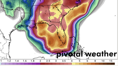
Deciphering where the storm will go now becomes the most important aspect of the forecast. The Weather Prediction Center is showing a wide area of very heavy rainfall associated with Alberto during the next seven days.
Here is a new experimental forecast from the NHC showing the earliest arrival time of Tropical Storm force wind from Alberto
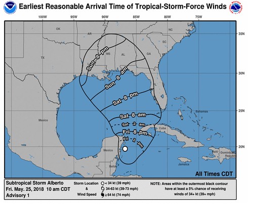
Tropical Storm conditions associated with #Alberto are possible across the Yucatan Peninsula and western Cuba through Saturday. Tropical Storm conditions could reach the northern Gulf Coast as early as Sunday morning. pic.twitter.com/MImTcKhB2z
— NHC Atlantic Ops (@NHC_Atlantic) May 25, 2018


