NOAA predicts chance for active season as Invest90L looms
Author: Nick Lilja
|| Published: 5/24/2018 at 11:02am
NOAA releases outlook
Today, NOAA released it’s thought on the 2018 Atlantic Hurricane Season. It falls in line with the researchers at Colorado State.
Seasonal prediction from the Colorado State tropical researchers for the 2018 Atlantic Hurricane SeasonSeasonal outlook from NOAA for the 2018 Atlantic Hurricane Season
Notice how the Colorado State meteorologists use the word “forecast” while NOAA uses the word “outlook” in the graphics. That is an important distinction. While CSU is forecasting for binary deterministic numbers, NOAA is showing a more probabilistic approach. CSU is forecasting 14 named storms, while NOAA is giving a range of 10 to 16.
From NOAA:
Forecasters predict a 35 percent chance of an above-normal season, a 40 percent chance of a near-normal season, and a 25 percent chance of a below-normal season for the upcoming hurricane season, which extends from June 1 to November 30.
The possibility of a weak El Nino developing, along with near-average sea-surface temperatures across the tropical Atlantic Ocean and Caribbean Sea, are two of the factors driving this outlook. These factors are set upon a backdrop of atmospheric and oceanic conditions that are conducive to hurricane development and have been producing stronger Atlantic hurricane seasons since 1995.
“With the advances made in hardware and computing over the course of the last year, the ability of NOAA scientists to both predict the path of storms and warn Americans who may find themselves in harm’s way is unprecedented,” said Secretary of Commerce Wilbur Ross. “The devastating hurricane season of 2017 demonstrated the necessity for prompt and accurate hurricane forecasts.”
Invest 90L
Latest from the National Hurricane Center:
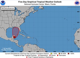
NHC update on Invest 90L as of 5/24/18 8am
A broad, stationary surface low pressure system centered over the southeastern Yucatan Peninsula is gradually becoming better defined. Although showers and thunderstorms, along with strong gusty winds, are confined primarily to the adjacent waters of the northwestern Caribbean Sea, gradual development of this system is expected during the next couple of days as it drifts northward near the Yucatan Peninsula. Environmental conditions are forecast to become more conducive for development through early next week, and a subtropical or tropical depression is likely to form by late Saturday over the southeastern Gulf of Mexico. Regardless of development, locally heavy rainfall is forecast across western Cuba and over much of Florida and the northern Gulf Coast into early next week. In addition, the threat of rip currents will steadily increase along the Gulf coast from Florida westward to Louisiana over Memorial Day weekend. For more information on these threats, please see products issued by your local weather office. The next Special Tropical Weather Outlook on this system will be issued by 200 PM EDT this afternoon.
* Formation chance through 48 hours…medium…40 percent.
* Formation chance through 5 days…high…80 percent.
Author of the article:
Nick Lilja
Nick is former television meteorologist with stints in Amarillo and Hattiesburg. During his time in Hattiesburg, he was also an adjunct professor at the University of Southern Mississippi. He is a graduate of both Oregon State and Syracuse University that now calls Houston home. Now that he is retired from TV, he runs this site and its app in his spare time.