There is a lot of buzz about the chance for a few snow flurries this week with temperatures running well below normal and a few systems gliding by to the south or passing by to the north. I’ve received a lot of interest from folks asking, “How much snow will I get?”
The short answer is “probably none.”
The longer answer, as you can probably already know, is “probably none, but you may see some, it depends on a lot of factors.
MONDAY & TUESDAY
For example, you may see maps like this:

This shows a chance for some snow across south central Mississippi, parts of Louisiana and Alabama on Monday afternoon. Okay. Cool, right?
But the problem is the data that made that map looks like this:

And that chart is now one that says, “snow” to me. Or any other meteorologist. We have moisture in the dendritic growth zone, but it is awfully dry down toward the surface. And there is a pretty stout inversion. And the wet-bulb temp is even above-freezing for about 1500ft (or more). And there is a east-southeast wind at the surface!
That means rain for Monday and Tuesday. A very cold rain. But rain.
Could things change? Sure. But we would need a lot of things to change not just one or two things. And looking at the higher resolution model guidance, it suggests a cooler surface, but an even warmer low-level of the atmosphere. In fact, it shows a chance for some elevated (not surface-based) thunderstorms with a chance for small hail and gusty wind!

What we would need is much cooler air between 1,000ft and 6,000ft, cooler air at the surface, an east-northeast wind, and more forcing up around 10,000ft to 15,000ft if we wanted to see snow on Monday or Tuesday.
It could happen, but the chances are pretty low.
THURSDAY & FRIDAY
The next system swings through on Thursday and into Friday. This one means business with colder air. And it has a better chance than Monday/Tuesday to ‘mean business’ with snow. But the chances are still dependent on a couple of factors.
Timing is the big one.

The above-map shows what the GFS thinks things will look like on Thursday evening. A system develops in the Gulf and glides northeast to our east. Then a big batch of cold air slams south to our west. Currently model guidance separates the chance for precipitation and the chance for sub-freezing temepratures through the column of air by about 9 hours in the general area.
But there will be a point overnight Thursday and into Friday morning where there may be some overlap in spots.

If this were to happen, there wouldn’t be much precipitation left and the cold air is going to be very, very dry. So this would be mainly a ‘light flurries or ice crystals’ kind of “snow” event for the area. Nothing sticking. But it would be in the air. For some. If they looked really hard.
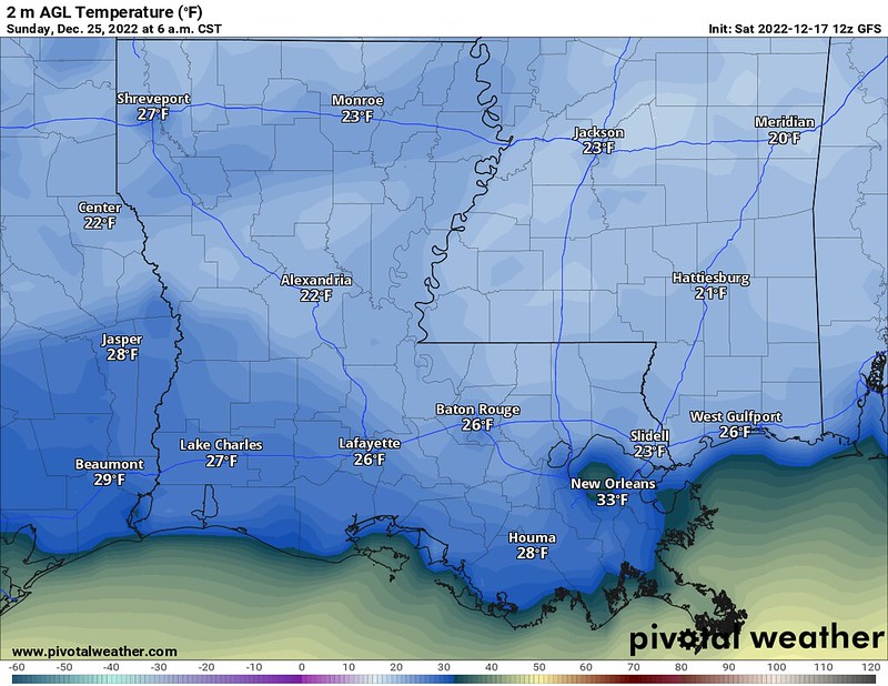
The main thing will be the cold. Temperatures will be running 10 to 30 degrees below normal by Christmas Eve.

That means a pretty cold Christmas Even and Christmas Day. In fact, we could be talking about some of the coldest temperatures (and wind chills) we have seen since 2018 for some spots.

And when it gets this cold in the area, it gets very, very difficult to see any precipitation. Instead it is just very, very dry.
SO, HOW MUCH SNOW WILL I SEE, NICK?
Based on the latest current, available data… Probably none. You may see some in the air. And if you get really, really lucky there might be enough for it to look like Christmas in the air for a few minutes. But the chances that you see any meaningful amount of measurable snow based on the weather data we have access to is very, very, very low.
It’ll be plenty cold. But by the time it is plenty cold, it will be too dry. And any chance for overlap is low. And even if it happened, it would be short-lived.


