We’ve got a few systems set to move through the area this week. Each system will bring its own round of “weather” but none of them look to offer a threat for tornadoes.
That’s a win!
The first round of rain will be Monday and into Tuesday with a system pushing by to the south. That should offer a chance for rain that lasts about 24 hours, from Monday afternoon through Tuesday afternoon. There isn’t much of a risk for any wintry weather with this round. A few folks, north of I-20, may be lucky enough on Monday afternoon/evening to mix in some snowflakes with the rain but sticking snow is very unlikely.
The next system arrives Thursday and Friday. That is when things get interesting. And certain things look even more interesting today than yesterday, while others look far less interesting. The main timeline for precip is going to be Thursday afternoon through early Friday morning.
So, let’s grab our guide and see if we can find some snow!

Now, let’s look at the data…

Let’s look closely….

Look more closely

Let’s look even more closlier
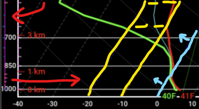
While we will have temperatures in the upper 30s and low 40s at the surface as well as temperatures cold enough for snow from about 925mb and up, we are missing some key ingredients.
There is no moisture in the Dendritic Growth Zone. There is also no forcing in the DGZ. There is no forcing under the DGZ, either.
So far the chance for snow is looing.. not great.
However! There is sufficient forcing closer to the surface where it is still below-freezing. So some light drizzle and ice crystal flurries may be possible. But flow-blown snow is looking less likely given the data today.
But it will be cold. And a little breezy. So we will have a wind chill to worry about, too, on top of the cold temperatures. Here is a look at the forecast data for high temperatures for December 23rd and December 24th.
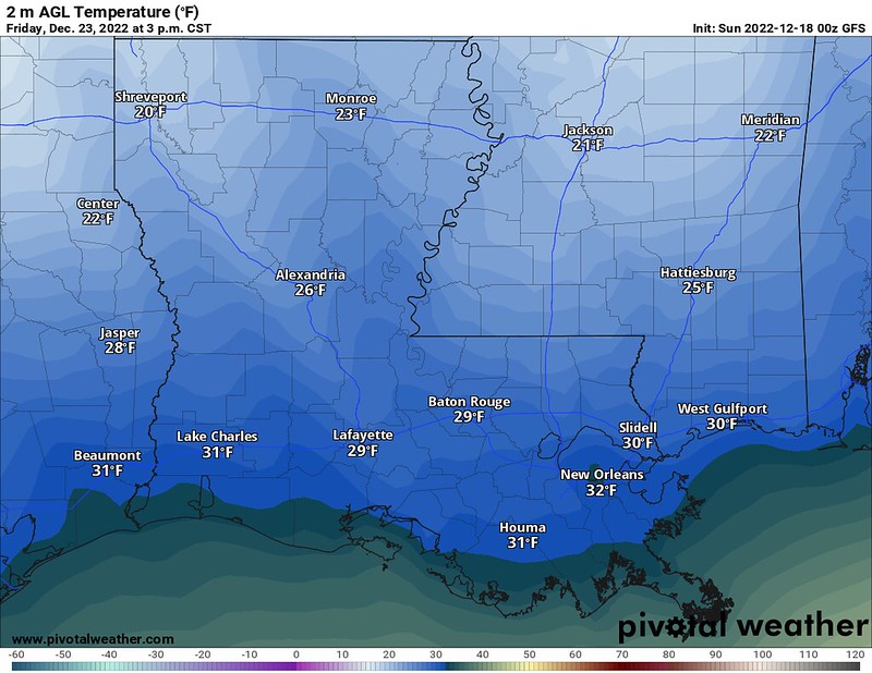
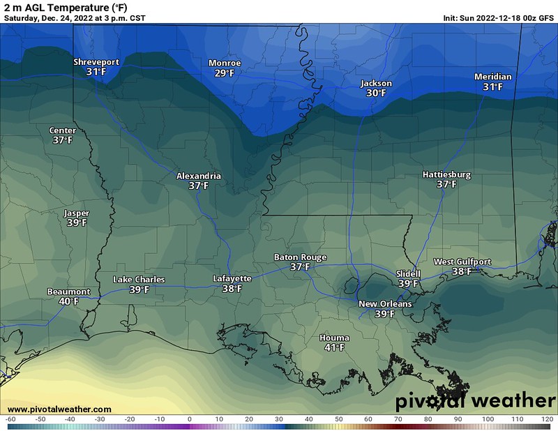
Cold stuff! And the wind chill will be down in the single digits at times and teens.
If you’re curious how wind chill works, here is a good explainer from the NWS:

DAY TO DAY FORECAST
Today
Sunny and chilly. Highs in the lower 50s. North winds 5 to 10 mph.
Tonight
Mostly clear. Cold with lows in the lower 30s. Northeast winds around 5 mph.
Monday
Increasing clouds through the day with some showers likely. Highs in the upper 40s. East winds 5 to 10 mph. Chance of rain 70 percent.
Monday Night
Rain. Lows around 40. East winds 5 to 10 mph. Chance of rain 90 percent.
Tuesday
Mostly cloudy lingering showers continue. Highs in the lower 50s. Northeast winds 5 to 10 mph. Chance of rain 60 percent.
Tuesday Night
Mostly cloudy. Lows in the lower 40s.
Wednesday
Mostly cloudy. Highs in the mid 50s.
Wednesday Night
Mostly cloudy. Lows in the mid 40s.
Thursday
Mostly cloudy. A few showers or storms possible in the afternoon/evening. Highs in the upper 50s.
Thursday Night
Mostly cloudy. Drizzle or ice crystal flurries possible after midnight. Lows around 25. Chance of precipitation around 10 percent.
Friday
Sunny. Cold. Highs in the lower 30s.
Friday Night
Mostly clear. Cold with lows around 20.
Saturday
Mostly sunny. Highs in the upper 30s.


