Author: Nick Lilja
|| Published: 8/7/2019 at 9:49am
Well, well, well… Here we are in early August looking toward the Autumn – the best time to be in South Mississippi. Football, lower humidity, cooler temperatures. All of the things that make dealing with summer in South Mississippi worth it.
The forecast from the CPC
The Climate Prediction Center is forecasting the persistence of El Nino through the fall. Because of that, warmer than average condition are in the forecast from the CPC for South Mississippi with no real ‘tell’ on whether there will be above-average or below-average precipitation.
Currently weak El Nino conditions persist but are expected to transition to ENSO neutral conditions within the next two months. Near average sea surface
temperatures (SSTs) with some smaller scale anomalies are observed from 140W to the coast of South America, and large-scale warmer than average SSTs are observed in the central and west Pacific.
Autumn outlook for temperatures from the CPC // Courtesy: cpc.noaa.gov
The latest weekly Nino 3.4 SST anomaly is +0.4 degree C, while the latest Nino 4 SST anomaly is +0.9 degree C, indicating the current gradient in equatorial SSTs from east to west. A large area of cooler than average subsurface water at depths of 100-200 meters in the west Pacific and from just below the surface to 100 meters depth in the east Pacific has persisted in the last two months, while warmer than average water persists from the surface to depths of 100 meters from 160E to 130W longitude. Oceanic heat content, determined from near equatorial Pacific Ocean temperature anomalies from the surface to a depth of 300 meters from the Date Line to 100W, has decreased to near zero anomaly in July. Low-level wind anomalies were near average over the tropical Pacific Ocean, and upper-level wind anomalies were westerly over the far eastern Pacific Ocean. Collectively, these oceanic and atmospheric conditions represent a continuation of weak El Nino conditions in July.
Autumn outlook for precipitation from the CPC // Courtesy: cpc.noaa.gov
Other boundary conditions relevant to the seasonal outlook are soil moisture anomalies and, in some areas, near-coastal SSTs. Widespread and persistent above normal precipitation for most of the CONUS during spring resulted in positive soil moisture anomalies for many areas of the central and eastern CONUS. Sea ice coverage for the Arctic is at record low amounts and SSTs are well above normal near the west coast of Alaska.
The CPC notes that there is a split in the models for El Nino going into the Autumn and Winter. The dynamical models suggest a return to neutral conditions while the statistical models suggest a continuing El Nino through Winter.
The Analog data
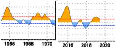
Using El Nino as a guide (like I have in previous years) it looks like the most analogous stretch of years is 1965 – 1970.
Comparing the last five years to similar five-year stretches in the past // Courtesy: cpc.noaa.gov
And 1969 is still the most analogous year. This has held true since, roughly, March.
So, from there, we look back at the Fall of 1969 and find out what the climate was like back then:
SEPT
Max
Min
Avg
Precip
Sum
2435
1787
–
0.75
Average
87
63.8
75.4
–
Normal
87.7
65.9
76.8
4.08
OCT
Max
Min
Avg
Precip
Sum
2415
1740
–
1.77
Average
77.9
56.1
67
–
Normal
79.5
54.5
67
3.75
NOV
Max
Min
Avg
Precip
Sum
2031
1238
–
1.71
Average
67.7
41.3
54.5
–
Normal
70
45
57.5
4.27
This is interesting. It shows near-normal temperatures (and maybe a touch below average) and below-average precipitation in 1969.
The Forecast
Given the available data, I don’t know that I trust the analog-only approach. However, given the recent trend of cold fronts diving further south than normal this summer, it may be an early indication that Autumn cold fronts may be able to make it further south a bit earlier. And those cold fronts would help keep temperatures near average.
SEPTEMBER
Temperatures: Slightly warmer than average
Precipitation: Average
OCTOBER
Temperatures: Average
Precipitation: Slightly drier than average
NOVEMBER
Temperatures: Average
Precipitation: Drier than average
Author of the article:
Nick Lilja
Nick is former television meteorologist with stints in Amarillo and Hattiesburg. During his time in Hattiesburg, he was also an adjunct professor at the University of Southern Mississippi. He is a graduate of both Oregon State and Syracuse University that now calls Houston home. Now that he is retired from TV, he runs this site and its app in his spare time.